Property Record
18101 N May Ave, Edmond, OK 73012


NEARBY LISTINGS FOR SALE OR LEASE
Property Detail
18101 N May Ave
Oklahoma City
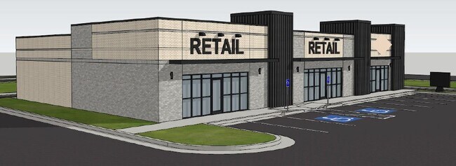
The Grove Retail Center
Oklahoma City, OK
THE GROVE RETAIL CENTER BLK 003 LOT 001
218471050
Oklahoma
Commercialacreage
Oklahoma
2023
001
2024
3.36 AC
108234
North Outlying
DEMOGRAPHICS near 18101 N May Ave
1 Mile
3 Mile
5 Mile
2024 Total Population
12,552
60,518
133,882
2029 Population
13,233
62,385
137,444
Pop Growth 2024-2029
+ 5.43%
+ 3.09%
+ 2.66%
Average Age
32
36
37
2024 Total Households
4,256
22,724
54,193
HH Growth 2024-2029
+ 5.57%
+ 3.26%
+ 2.80%
Median Household Inc
$124,651
$98,654
$80,836
Avg Household Size
2.90
2.60
2.40
2024 Avg HH Vehicles
2.00
2.00
2.00
Median Home Value
$272,280
$263,260
$253,675
Median Year Built
2011
2006
1999
Nearby Places
Map Layers
Map Styles
 Street
 Aerial
- Restaurants
- Banks
- Shops
- Fitness
- Groceries
PUBLIC TRANSPORTATION
AIRPORT
Will Rogers World
DRIVE
WALK
Distance
Will Rogers World
33 min
21.0 mi
Freight Ports
Tulsa Port Of Catoosa
DRIVE
WALK
Distance
Tulsa Port Of Catoosa
134 min
123.0 mi
SALE & LEASE HISTORY
LISTING DATE
SALE/LEASE

Feb 26, 2025
For Lease
Nearby Properties
Address
Land Use
TOTAL SIZE
Lot Size
Zoning
Address
Land Use
TOTAL SIZE
Lot Size
Zoning
140,312 SF
7.91 AC
C-3
Address
Land Use
TOTAL SIZE
Lot Size
Zoning
27.22 AC
PUD
Address
Land Use
TOTAL SIZE
Lot Size
Zoning
460,954 SF
24.83 AC
PUD
Address
Land Use
TOTAL SIZE
Lot Size
Zoning
41,733 SF
2.63 AC
O-1
Address
Land Use
TOTAL SIZE
Lot Size
Zoning
41,733 SF
2.47 AC
C-3
Address
Land Use
TOTAL SIZE
Lot Size
Zoning
376,079 SF
29.77 AC
PUD
Address
Land Use
TOTAL SIZE
Lot Size
Zoning
8,354 SF
16.65 AC
PUD
Address
Land Use
TOTAL SIZE
Lot Size
Zoning
304,423 SF
31.20 AC
PUD
Address
Land Use
TOTAL SIZE
Lot Size
Zoning
184,238 SF
7.35 AC
C-3
Address
Land Use
TOTAL SIZE
Lot Size
Zoning
10,811 SF
1.46 AC
PUD
Address
Land Use
TOTAL SIZE
Lot Size
Zoning
247,230 SF
22.75 AC
PUD
Address
Land Use
TOTAL SIZE
Lot Size
Zoning
297,836 SF
15 AC
PUD
Address
Land Use
TOTAL SIZE
Lot Size
Zoning
302,058 SF
23.78 AC
PUD
Address
Land Use
TOTAL SIZE
Lot Size
Zoning
227,714 SF
14.15 AC
PUD
Address
Land Use
TOTAL SIZE
Lot Size
Zoning
255,921 SF
9.93 AC
PUD
Address
Land Use
TOTAL SIZE
Lot Size
Zoning
191,504 SF
20.03 AC
PUD
Address
Land Use
TOTAL SIZE
Lot Size
Zoning
235,612 SF
28.09 AC
PUD
Address
Land Use
TOTAL SIZE
Lot Size
Zoning
279,215 SF
11.58 AC
PUD
Address
Land Use
TOTAL SIZE
Lot Size
Zoning
403,628 SF
15.57 AC
C-3
Address
Land Use
TOTAL SIZE
Lot Size
Zoning
108,800 SF
7.05 AC
PUD
Address
Land Use
TOTAL SIZE
Lot Size
Zoning
131,262 SF
11.34 AC
O-1
Address
Land Use
TOTAL SIZE
Lot Size
Zoning
145,635 SF
12.11 AC
C-3
Address
Land Use
TOTAL SIZE
Lot Size
Zoning
62,580 SF
11.99 AC
C-3
Address
Land Use
TOTAL SIZE
Lot Size
Zoning
150,777 SF
12 AC
C-3
Address
Land Use
TOTAL SIZE
Lot Size
Zoning
151,156 SF
13.71 AC
Address
Land Use
TOTAL SIZE
Lot Size
Zoning
133,880 SF
9.70 AC
R-4
Address
Land Use
TOTAL SIZE
Lot Size
Zoning
2,086 SF
11.67 AC
PUD
Address
Land Use
TOTAL SIZE
Lot Size
Zoning
253,426 SF
23.80 AC
Address
Land Use
TOTAL SIZE
Lot Size
Zoning
140,434 SF
18.14 AC
PUD
Address
Land Use
TOTAL SIZE
Lot Size
Zoning
154,244 SF
6.44 AC
PUD
The World's #1 Commercial Real Estate Marketplace
Connect with us
© 2026 CoStar Group
The information above has been obtained from sources believed reliable. While we do not doubt its accuracy we have not verified it and make no guarantee, warranty or representation about it. It is your responsibility to independently confirm its accuracy and completeness. Any projections, opinions, assumptions, or estimates used are for example only and do not represent the current or future performance of the property. The value of this transaction to you depends on tax and other factors which should be evaluated by your tax, financial, and legal advisors. You and your advisors should conduct a careful, independent investigation of the property to determine to your satisfaction the suitability of the property for your needs.