Property Record
1811 E 5Th St, Lumberton, NC 28358
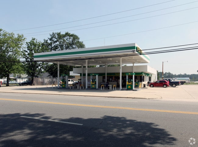

Property Detail
1811 E 5Th St
3240-03-015
LTS 133 THRU 136 SESSOMS PROPERTY
Servicestation
Robeson
B4
North Carolina
B and X Area of moderate flood hazard, usually the area between the limits of the 100-year and 500-year floods.
133-136
2025
0.41 AC
2025
Other Market Areas
961200
Lumberton, NC
6,875 SF
NEARBY LISTINGS FOR SALE OR LEASE
-
-
No Photo
-
-
-
-
View all Lumberton listings for sale on LoopNet.com
DEMOGRAPHICS near 1811 E 5Th St
1 mile
3 mile
5 mile
2025 Total Population
5,175
21,002
31,606
2030 Population
5,337
21,779
32,750
Pop Growth 2025-2030
+ 3.13%
+ 3.70%
+ 3.62%
Average Age
37
38
39
2025 Total Households
2,072
8,196
12,140
HH Growth 2025-2030
+ 3.19%
+ 3.84%
+ 3.76%
Median Household Inc
$41,130
$41,760
$45,451
Avg Household Size
2.40
2.40
2.40
2025 Avg HH Vehicles
1.00
2.00
2.00
Median Home Value
$96,566
$121,543
$122,375
Median Year Built
1970
1975
1979
Nearby Places
Map Layers
Map Styles
 Street
 Aerial
Layers
 Traffic
 Biking
Places
Listings with unknown addresses are not visible on the map
- Restaurants
- Banks
- Shops
- Fitness
- Groceries
PUBLIC TRANSPORTATION
AIRPORT
Fayetteville Regional/Grannis Field
Drive
Walk
Distance
Fayetteville Regional/Grannis Field
40 min
30.4 mi
Freight Ports
Port of Wilmington
Drive
Walk
Distance
Port of Wilmington
103 min
72.0 mi
Nearby Properties
Address
Land Use
TOTAL SIZE
Lot Size
Zoning
Address
Land Use
TOTAL SIZE
Lot Size
Zoning
59,810 SF
7.69 AC
R7
Address
Land Use
TOTAL SIZE
Lot Size
Zoning
116,616 SF
10.18 AC
B6
Address
Land Use
TOTAL SIZE
Lot Size
Zoning
82,115 SF
39.22 AC
R15
Address
Land Use
TOTAL SIZE
Lot Size
Zoning
24,173 SF
44.32 AC
B3
Address
Land Use
TOTAL SIZE
Lot Size
Zoning
134,160 SF
0.26 AC
B6
Address
Land Use
TOTAL SIZE
Lot Size
Zoning
128,531 SF
22.20 AC
B4
Address
Land Use
TOTAL SIZE
Lot Size
Zoning
24,984 SF
41.13 AC
R11
Address
Land Use
TOTAL SIZE
Lot Size
Zoning
67,728 SF
1.50 AC
B1
Address
Land Use
TOTAL SIZE
Lot Size
Zoning
69,765 SF
9.51 AC
B4
Address
Land Use
TOTAL SIZE
Lot Size
Zoning
2,187 SF
18.75 AC
R3
Address
Land Use
TOTAL SIZE
Lot Size
Zoning
4,048 SF
12.73 AC
R3
Address
Land Use
TOTAL SIZE
Lot Size
Zoning
88,710 SF
1.11 AC
B1
Address
Land Use
TOTAL SIZE
Lot Size
Zoning
95,143 SF
7.55 AC
B4
Address
Land Use
TOTAL SIZE
Lot Size
Zoning
12,938 SF
115.63 AC
RA
Address
Land Use
TOTAL SIZE
Lot Size
Zoning
51,003 SF
8.49 AC
B3
Address
Land Use
TOTAL SIZE
Lot Size
Zoning
62,404 SF
12.88 AC
Address
Land Use
TOTAL SIZE
Lot Size
Zoning
59,635 SF
10.24 AC
R11
Address
Land Use
TOTAL SIZE
Lot Size
Zoning
75,704 SF
7.60 AC
R3
Address
Land Use
TOTAL SIZE
Lot Size
Zoning
5,784 SF
903.32 AC
RA
Address
Land Use
TOTAL SIZE
Lot Size
Zoning
24,880 SF
19.30 AC
R20
Address
Land Use
TOTAL SIZE
Lot Size
Zoning
149,800 SF
66.53 AC
M2
Address
Land Use
TOTAL SIZE
Lot Size
Zoning
1,232 SF
10.68 AC
R7
Address
Land Use
TOTAL SIZE
Lot Size
Zoning
7,700 SF
10.66 AC
M1
Address
Land Use
TOTAL SIZE
Lot Size
Zoning
39,439 SF
1.10 AC
B5
Address
Land Use
TOTAL SIZE
Lot Size
Zoning
35,650 SF
9.25 AC
Address
Land Use
TOTAL SIZE
Lot Size
Zoning
13,367 SF
6.09 AC
R7
Address
Land Use
TOTAL SIZE
Lot Size
Zoning
373,485 SF
102.67 AC
RA
Address
Land Use
TOTAL SIZE
Lot Size
Zoning
59,800 SF
11.64 AC
B4
Address
Land Use
TOTAL SIZE
Lot Size
Zoning
51,067 SF
9.02 AC
B4
Address
Land Use
TOTAL SIZE
Lot Size
Zoning
68,262 SF
9.18 AC
B4
The World's #1 Commercial Real Estate Marketplace
Connect with us
© 2026 CoStar Group
The information above has been obtained from sources believed reliable. While we do not doubt its accuracy we have not verified it and make no guarantee, warranty or representation about it. It is your responsibility to independently confirm its accuracy and completeness. Any projections, opinions, assumptions, or estimates used are for example only and do not represent the current or future performance of the property. The value of this transaction to you depends on tax and other factors which should be evaluated by your tax, financial, and legal advisors. You and your advisors should conduct a careful, independent investigation of the property to determine to your satisfaction the suitability of the property for your needs.