Property Record
1811 E Mcmurray Blvd, Casa Grande, AZ 85122


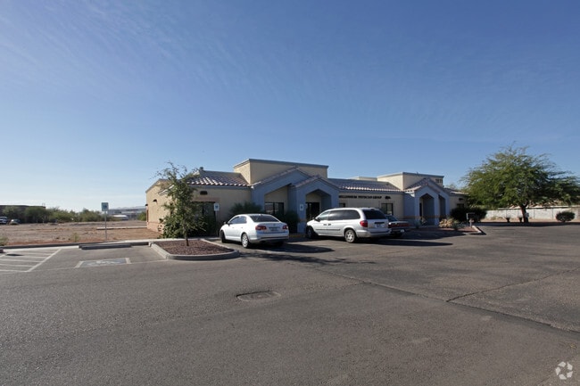
Property Detail
1811 E Mcmurray Blvd
505-22-014V
COM @ SE COR SEC 22-6S-6E TH N-1670.74 TH W-1172.78 TO POB TH S-2 33.91 TH W-100 TH N 59D W-142.63 TH N 30D E-187.48 TH E-128.58 TO POB 40893.65 SQ FT 0.88 AC
Medicalbuilding
Pinal
UNDESIGNAT
Arizona
B and X Area of moderate flood hazard, usually the area between the limits of the 100-year and 500-year floods.
0.92 AC
2024
Pinal County
2025
Phoenix
001405
Phoenix-Mesa-Chandler, AZ
6,278 SF
NEARBY LISTINGS FOR SALE OR LEASE
DEMOGRAPHICS near 1811 E Mcmurray Blvd
1 mile
3 mile
5 mile
2025 Total Population
9,570
45,760
69,615
2030 Population
11,656
54,230
82,538
Pop Growth 2025-2030
+ 21.80%
+ 18.51%
+ 18.56%
Average Age
54
43
42
2025 Total Households
4,392
17,458
26,154
HH Growth 2025-2030
+ 22.04%
+ 18.64%
+ 18.67%
Median Household Inc
$71,360
$64,195
$62,380
Avg Household Size
2.10
2.50
2.60
2025 Avg HH Vehicles
2.00
2.00
2.00
Median Home Value
$300,669
$323,927
$315,955
Median Year Built
2005
2002
2002
Nearby Places
Map Layers
Map Styles
 Street
 Aerial
Layers
 Traffic
 Biking
Places
Listings with unknown addresses are not visible on the map
- Restaurants
- Banks
- Shops
- Fitness
- Groceries
PUBLIC TRANSPORTATION
AIRPORT
Phoenix-Mesa Gateway
Drive
Walk
Distance
Phoenix-Mesa Gateway
61 min
43.9 mi
SALE & LEASE HISTORY
LISTING DATE
SALE/LEASE

May 01, 2017
For Sale
Nearby Properties
Address
Land Use
TOTAL SIZE
Lot Size
Zoning
Address
Land Use
TOTAL SIZE
Lot Size
Zoning
48,433 SF
266.50 AC
Address
Land Use
TOTAL SIZE
Lot Size
Zoning
272,663 SF
27.20 AC
Address
Land Use
TOTAL SIZE
Lot Size
Zoning
216,795 SF
11.15 AC
Address
Land Use
TOTAL SIZE
Lot Size
Zoning
131,386 SF
1.29 AC
UNDESIGNAT
Address
Land Use
TOTAL SIZE
Lot Size
Zoning
222,134 SF
24.14 AC
Address
Land Use
TOTAL SIZE
Lot Size
Zoning
196,294 SF
4.24 AC
Address
Land Use
TOTAL SIZE
Lot Size
Zoning
63,541 SF
12.10 AC
Address
Land Use
TOTAL SIZE
Lot Size
Zoning
134,042 SF
15.68 AC
Address
Land Use
TOTAL SIZE
Lot Size
Zoning
55,295 SF
12.14 AC
Address
Land Use
TOTAL SIZE
Lot Size
Zoning
131,275 SF
8.85 AC
Address
Land Use
TOTAL SIZE
Lot Size
Zoning
42,077 SF
3.37 AC
Address
Land Use
TOTAL SIZE
Lot Size
Zoning
125,899 SF
10.47 AC
Address
Land Use
TOTAL SIZE
Lot Size
Zoning
81,467 SF
11.96 AC
Address
Land Use
TOTAL SIZE
Lot Size
Zoning
143,860 SF
14.88 AC
Address
Land Use
TOTAL SIZE
Lot Size
Zoning
121,969 SF
9.36 AC
Address
Land Use
TOTAL SIZE
Lot Size
Zoning
93,477 SF
4.22 AC
UNDESIGNAT
Address
Land Use
TOTAL SIZE
Lot Size
Zoning
111,066 SF
5.04 AC
UNDESIGNAT
Address
Land Use
TOTAL SIZE
Lot Size
Zoning
88,755 SF
7.60 AC
Address
Land Use
TOTAL SIZE
Lot Size
Zoning
137,735 SF
14.12 AC
Address
Land Use
TOTAL SIZE
Lot Size
Zoning
156,264 SF
10.70 AC
UNDESIGNAT
Address
Land Use
TOTAL SIZE
Lot Size
Zoning
0.12 AC
Address
Land Use
TOTAL SIZE
Lot Size
Zoning
100,086 SF
8.24 AC
Address
Land Use
TOTAL SIZE
Lot Size
Zoning
74,433 SF
15.44 AC
UNDESIGNAT
Address
Land Use
TOTAL SIZE
Lot Size
Zoning
43,355 SF
5.91 AC
Address
Land Use
TOTAL SIZE
Lot Size
Zoning
45,799 SF
7.24 AC
Address
Land Use
TOTAL SIZE
Lot Size
Zoning
320,334 SF
9.38 AC
Address
Land Use
TOTAL SIZE
Lot Size
Zoning
115,058 SF
13.41 AC
UNDESIGNAT
Address
Land Use
TOTAL SIZE
Lot Size
Zoning
41,824 SF
8.74 AC
Address
Land Use
TOTAL SIZE
Lot Size
Zoning
51,866 SF
5.88 AC
UNDESIGNAT
Address
Land Use
TOTAL SIZE
Lot Size
Zoning
28,115 SF
8.92 AC
The World's #1 Commercial Real Estate Marketplace
Connect with us
© 2026 CoStar Group
The information above has been obtained from sources believed reliable. While we do not doubt its accuracy we have not verified it and make no guarantee, warranty or representation about it. It is your responsibility to independently confirm its accuracy and completeness. Any projections, opinions, assumptions, or estimates used are for example only and do not represent the current or future performance of the property. The value of this transaction to you depends on tax and other factors which should be evaluated by your tax, financial, and legal advisors. You and your advisors should conduct a careful, independent investigation of the property to determine to your satisfaction the suitability of the property for your needs.