Property Record
1811 E Northrop Blvd, Chandler, AZ 85286
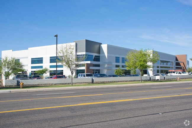

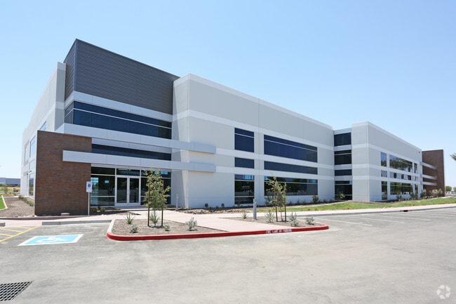

Property Detail
1811 E Northrop Blvd
303-29-843D
IRGENS CHANDLER AIRPORT CENTER PHASE 3 MLD MCR 1414-01
Officebuilding
Maricopa
PAD
Arizona
C and X Area of minimal flood hazard, usually depicted on FIRMs as above the 500-year flood level.
2
2025
10.78 AC
2025
Chandler
812400
Phoenix
82,044 SF
Phoenix-Mesa-Chandler, AZ
NEARBY LISTINGS FOR SALE OR LEASE
DEMOGRAPHICS near 1811 E Northrop Blvd
1 mile
3 mile
5 mile
2025 Total Population
9,035
105,145
302,057
2030 Population
9,401
108,715
313,488
Pop Growth 2025-2030
+ 4.05%
+ 3.40%
+ 3.78%
Average Age
37
37
38
2025 Total Households
3,584
35,457
107,171
HH Growth 2025-2030
+ 4.24%
+ 3.47%
+ 3.84%
Median Household Inc
$112,750
$116,868
$115,183
Avg Household Size
2.50
2.90
2.70
2025 Avg HH Vehicles
2.00
2.00
2.00
Median Home Value
$509,987
$602,816
$603,185
Median Year Built
2009
2002
2000
Nearby Places
Map Layers
Map Styles
 Street
 Aerial
Layers
 Traffic
 Biking
Places
Listings with unknown addresses are not visible on the map
- Restaurants
- Banks
- Shops
- Fitness
- Groceries
PUBLIC TRANSPORTATION
AIRPORT
Phoenix Sky Harbor International
Drive
Walk
Distance
Phoenix Sky Harbor International
25 min
22.3 mi
SALE & LEASE HISTORY
LISTING DATE
SALE/LEASE

Oct 09, 2017
For Lease
Nov 03, 2022
For Lease
May 25, 2017
For Lease
Mar 30, 2022
For Lease
Jun 19, 2017
For Sale
Nearby Properties
Address
Land Use
TOTAL SIZE
Lot Size
Zoning
Address
Land Use
TOTAL SIZE
Lot Size
Zoning
10.02 AC
Address
Land Use
TOTAL SIZE
Lot Size
Zoning
1.13 AC
Address
Land Use
TOTAL SIZE
Lot Size
Zoning
30,414 SF
97.19 AC
PAD
Address
Land Use
TOTAL SIZE
Lot Size
Zoning
434,857 SF
36.73 AC
PF
Address
Land Use
TOTAL SIZE
Lot Size
Zoning
288,023 SF
48.20 AC
PAD
Address
Land Use
TOTAL SIZE
Lot Size
Zoning
498,377 SF
29.12 AC
Address
Land Use
TOTAL SIZE
Lot Size
Zoning
263,599 SF
18.33 AC
PAD
Address
Land Use
TOTAL SIZE
Lot Size
Zoning
416,954 SF
9.59 AC
PF
Address
Land Use
TOTAL SIZE
Lot Size
Zoning
416,098 SF
22.48 AC
Address
Land Use
TOTAL SIZE
Lot Size
Zoning
348,249 SF
6.42 AC
M-H
Address
Land Use
TOTAL SIZE
Lot Size
Zoning
363,785 SF
46.73 AC
Address
Land Use
TOTAL SIZE
Lot Size
Zoning
374,847 SF
20.84 AC
PAD
Address
Land Use
TOTAL SIZE
Lot Size
Zoning
445,862 SF
36.70 AC
LI
Address
Land Use
TOTAL SIZE
Lot Size
Zoning
563,460 SF
33.65 AC
Address
Land Use
TOTAL SIZE
Lot Size
Zoning
425,886 SF
19.08 AC
MFM
Address
Land Use
TOTAL SIZE
Lot Size
Zoning
465,645 SF
30.78 AC
PAD
Address
Land Use
TOTAL SIZE
Lot Size
Zoning
300,885 SF
37.63 AC
AG
Address
Land Use
TOTAL SIZE
Lot Size
Zoning
444,707 SF
21.62 AC
I-2
Address
Land Use
TOTAL SIZE
Lot Size
Zoning
329,305 SF
18.06 AC
PAD
Address
Land Use
TOTAL SIZE
Lot Size
Zoning
308,238 SF
36.64 AC
PAD
Address
Land Use
TOTAL SIZE
Lot Size
Zoning
324,283 SF
18.75 AC
PAD
Address
Land Use
TOTAL SIZE
Lot Size
Zoning
317,959 SF
23.86 AC
Address
Land Use
TOTAL SIZE
Lot Size
Zoning
159,419 SF
10.11 AC
RC
Address
Land Use
TOTAL SIZE
Lot Size
Zoning
199,808 SF
48.05 AC
PAD
Address
Land Use
TOTAL SIZE
Lot Size
Zoning
316,658 SF
47.91 AC
PAD
Address
Land Use
TOTAL SIZE
Lot Size
Zoning
128,416 SF
8.28 AC
C-BP
Address
Land Use
TOTAL SIZE
Lot Size
Zoning
325,445 SF
15.28 AC
PAD
Address
Land Use
TOTAL SIZE
Lot Size
Zoning
383,461 SF
25.76 AC
PAD
Address
Land Use
TOTAL SIZE
Lot Size
Zoning
319,061 SF
18.51 AC
PAD
Address
Land Use
TOTAL SIZE
Lot Size
Zoning
208,339 SF
17.47 AC
LI
The World's #1 Commercial Real Estate Marketplace
Connect with us
© 2026 CoStar Group
The information above has been obtained from sources believed reliable. While we do not doubt its accuracy we have not verified it and make no guarantee, warranty or representation about it. It is your responsibility to independently confirm its accuracy and completeness. Any projections, opinions, assumptions, or estimates used are for example only and do not represent the current or future performance of the property. The value of this transaction to you depends on tax and other factors which should be evaluated by your tax, financial, and legal advisors. You and your advisors should conduct a careful, independent investigation of the property to determine to your satisfaction the suitability of the property for your needs.