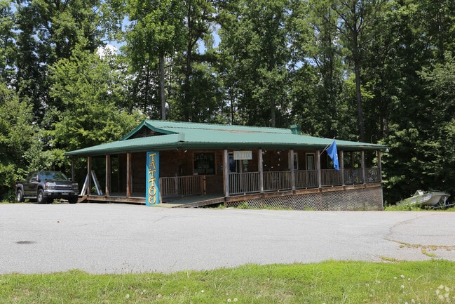
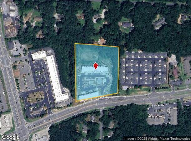
Property Record
1811 Eagle Dr, Woodstock, GA 30189
NEARBY LISTINGS FOR SALE OR LEASE
Property Detail
1811 Eagle Dr
Atlanta-Sandy Springs-Roswell, GA
Thomas L Williams & Assoc
015N05-00000-108-000-0000
LL 972; 21ST D PB 6 PG 133
Apartment
Cherokee
X
Georgia
13057C0327E
972
2025
4.77 AC
2025
Cherokee/Woodstock
091006
Atlanta
39,792 SF
DEMOGRAPHICS near 1811 Eagle Dr
1 Mile
3 Mile
5 Mile
2024 Total Population
8,906
64,862
154,984
2029 Population
10,133
74,035
171,026
Pop Growth 2024-2029
+ 13.78%
+ 14.14%
+ 10.35%
Average Age
39
40
39
2024 Total Households
3,048
23,534
56,694
HH Growth 2024-2029
+ 13.91%
+ 14.33%
+ 10.54%
Median Household Inc
$99,834
$93,650
$91,954
Avg Household Size
2.90
2.70
2.70
2024 Avg HH Vehicles
2.00
2.00
2.00
Median Home Value
$294,697
$311,934
$311,865
Median Year Built
1994
1994
1994
Nearby Places
- Restaurants
- Banks
- Shops
- Fitness
- Groceries
PUBLIC TRANSPORTATION
AIRPORT
Hartsfield - Jackson Atlanta International
DRIVE
WALK
Distance
Hartsfield - Jackson Atlanta International
54 min
39.3 mi
SALE & LEASE HISTORY
LISTING DATE
SALE/LEASE

Sep 23, 2016
For Sale
Nearby Properties
Address
Land Use
TOTAL SIZE
Lot Size
Zoning
Address
Land Use
TOTAL SIZE
Lot Size
Zoning
523,803 SF
148.37 AC
R-40
Address
Land Use
TOTAL SIZE
Lot Size
Zoning
56,439 SF
13.69 AC
GC
Address
Land Use
TOTAL SIZE
Lot Size
Zoning
189,621 SF
12.16 AC
R-40
Address
Land Use
TOTAL SIZE
Lot Size
Zoning
309,011 SF
64.20 AC
PUD
Address
Land Use
TOTAL SIZE
Lot Size
Zoning
175,587 SF
17.71 AC
RTH
Address
Land Use
TOTAL SIZE
Lot Size
Zoning
197,890 SF
14.60 AC
R-4
Address
Land Use
TOTAL SIZE
Lot Size
Zoning
188,105 SF
25.86 AC
R-5
Address
Land Use
TOTAL SIZE
Lot Size
Zoning
201,331 SF
15.48 AC
RM16
Address
Land Use
TOTAL SIZE
Lot Size
Zoning
346,900 SF
104.10 AC
CD
Address
Land Use
TOTAL SIZE
Lot Size
Zoning
235,861 SF
31.92 AC
RM10
Address
Land Use
TOTAL SIZE
Lot Size
Zoning
238,600 SF
21.10 AC
R-3
Address
Land Use
TOTAL SIZE
Lot Size
Zoning
91,547 SF
18.48 AC
R-3
Address
Land Use
TOTAL SIZE
Lot Size
Zoning
255,460 SF
20.28 AC
RM16
Address
Land Use
TOTAL SIZE
Lot Size
Zoning
113,849 SF
7.46 AC
R-5
Address
Land Use
TOTAL SIZE
Lot Size
Zoning
12,032 SF
17.14 AC
RM16
Address
Land Use
TOTAL SIZE
Lot Size
Zoning
85,671 SF
12.25 AC
RM10
Address
Land Use
TOTAL SIZE
Lot Size
Zoning
194,729 SF
29.67 AC
GC
Address
Land Use
TOTAL SIZE
Lot Size
Zoning
134,017 SF
32.51 AC
AG
Address
Land Use
TOTAL SIZE
Lot Size
Zoning
117,247 SF
21.44 AC
PUD
Address
Land Use
TOTAL SIZE
Lot Size
Zoning
216,432 SF
16.79 AC
LI
Address
Land Use
TOTAL SIZE
Lot Size
Zoning
132,022 SF
12.69 AC
GC
Address
Land Use
TOTAL SIZE
Lot Size
Zoning
86,307 SF
13.49 AC
GC
Address
Land Use
TOTAL SIZE
Lot Size
Zoning
2,768 SF
60 AC
PUD
Address
Land Use
TOTAL SIZE
Lot Size
Zoning
77,924 SF
9.84 AC
GC
Address
Land Use
TOTAL SIZE
Lot Size
Zoning
3,870 SF
98.57 AC
R-40
Address
Land Use
TOTAL SIZE
Lot Size
Zoning
61,433 SF
9.52 AC
GC
Address
Land Use
TOTAL SIZE
Lot Size
Zoning
28,438 SF
GC
Address
Land Use
TOTAL SIZE
Lot Size
Zoning
138,918 SF
13.96 AC
GC
Address
Land Use
TOTAL SIZE
Lot Size
Zoning
33,920 SF
1.78 AC
GC
Address
Land Use
TOTAL SIZE
Lot Size
Zoning
36,413 SF
2.22 AC
LI
The World's #1 Commercial Real Estate Marketplace
Connect with us
© 2025 CoStar Group
The information above has been obtained from sources believed reliable. While we do not doubt its accuracy we have not verified it and make no guarantee, warranty or representation about it. It is your responsibility to independently confirm its accuracy and completeness. Any projections, opinions, assumptions, or estimates used are for example only and do not represent the current or future performance of the property. The value of this transaction to you depends on tax and other factors which should be evaluated by your tax, financial, and legal advisors. You and your advisors should conduct a careful, independent investigation of the property to determine to your satisfaction the suitability of the property for your needs.