Property Record
1813 Cannon Dr, Mansfield, TX 76063


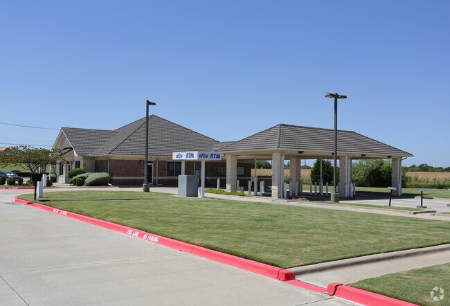
Property Detail
1813 Cannon Dr
Dallas-Fort Worth-Arlington, TX
ARLINGTON FEDERAL CREDIT UNION BLOCK 1 LOT 1
40169251
Tarrant
Commercialnec
Texas
B and X Area of moderate flood hazard, usually the area between the limits of the 100-year and 500-year floods.
1
2024
2 AC
2025
SE Outlying Tarrant
111312
Dallas/Ft Worth
3,916 SF
NEARBY LISTINGS FOR SALE OR LEASE
DEMOGRAPHICS near 1813 Cannon Dr
1 mile
3 mile
5 mile
2025 Total Population
4,834
78,299
166,575
2030 Population
5,247
84,073
177,673
Pop Growth 2025-2030
+ 8.54%
+ 7.37%
+ 6.66%
Average Age
43
37
37
2025 Total Households
1,636
25,930
53,167
HH Growth 2025-2030
+ 8.92%
+ 7.55%
+ 6.90%
Median Household Inc
$155,056
$111,988
$112,744
Avg Household Size
2.80
3.00
3.10
2025 Avg HH Vehicles
2.00
2.00
2.00
Median Home Value
$474,757
$403,632
$387,341
Median Year Built
1999
2005
2004
Nearby Places
Map Layers
Map Styles
 Street
 Aerial
Layers
 Traffic
 Biking
Places
Listings with unknown addresses are not visible on the map
- Restaurants
- Banks
- Shops
- Fitness
- Groceries
PUBLIC TRANSPORTATION
AIRPORT
Dallas-Fort Worth International
Drive
Walk
Distance
Dallas-Fort Worth International
38 min
26.4 mi
Dallas Love Field
Drive
Walk
Distance
Dallas Love Field
48 min
35.0 mi
Nearby Properties
Address
Land Use
TOTAL SIZE
Lot Size
Zoning
Address
Land Use
TOTAL SIZE
Lot Size
Zoning
565,115 SF
27.71 AC
Address
Land Use
TOTAL SIZE
Lot Size
Zoning
447,960 SF
29.42 AC
Address
Land Use
TOTAL SIZE
Lot Size
Zoning
512,471 SF
69.41 AC
Address
Land Use
TOTAL SIZE
Lot Size
Zoning
22.94 AC
Address
Land Use
TOTAL SIZE
Lot Size
Zoning
426,667 SF
12.87 AC
Address
Land Use
TOTAL SIZE
Lot Size
Zoning
339,196 SF
12.48 AC
Address
Land Use
TOTAL SIZE
Lot Size
Zoning
352,649 SF
17.16 AC
Address
Land Use
TOTAL SIZE
Lot Size
Zoning
312,848 SF
17.20 AC
Address
Land Use
TOTAL SIZE
Lot Size
Zoning
213,607 SF
40.03 AC
Address
Land Use
TOTAL SIZE
Lot Size
Zoning
348,951 SF
18.66 AC
Address
Land Use
TOTAL SIZE
Lot Size
Zoning
317,142 SF
11.40 AC
Address
Land Use
TOTAL SIZE
Lot Size
Zoning
413,000 SF
19.16 AC
Address
Land Use
TOTAL SIZE
Lot Size
Zoning
298,988 SF
7.16 AC
Address
Land Use
TOTAL SIZE
Lot Size
Zoning
273,381 SF
8.32 AC
Address
Land Use
TOTAL SIZE
Lot Size
Zoning
276,467 SF
7.61 AC
Address
Land Use
TOTAL SIZE
Lot Size
Zoning
246,204 SF
15.16 AC
Address
Land Use
TOTAL SIZE
Lot Size
Zoning
258,908 SF
22.41 AC
Address
Land Use
TOTAL SIZE
Lot Size
Zoning
249,922 SF
17.26 AC
Address
Land Use
TOTAL SIZE
Lot Size
Zoning
255,134 SF
21.62 AC
Address
Land Use
TOTAL SIZE
Lot Size
Zoning
79,330 SF
23.78 AC
Address
Land Use
TOTAL SIZE
Lot Size
Zoning
353,016 SF
8.08 AC
Address
Land Use
TOTAL SIZE
Lot Size
Zoning
209,307 SF
15.34 AC
Address
Land Use
TOTAL SIZE
Lot Size
Zoning
330,444 SF
9.74 AC
Address
Land Use
TOTAL SIZE
Lot Size
Zoning
325,213 SF
8.20 AC
Address
Land Use
TOTAL SIZE
Lot Size
Zoning
724,286 SF
48.41 AC
Address
Land Use
TOTAL SIZE
Lot Size
Zoning
208,630 SF
8.62 AC
Address
Land Use
TOTAL SIZE
Lot Size
Zoning
231,551 SF
25.69 AC
Address
Land Use
TOTAL SIZE
Lot Size
Zoning
98,664 SF
5.47 AC
Address
Land Use
TOTAL SIZE
Lot Size
Zoning
165,932 SF
10.70 AC
Address
Land Use
TOTAL SIZE
Lot Size
Zoning
234,580 SF
65.82 AC
The World's #1 Commercial Real Estate Marketplace
Connect with us
© 2026 CoStar Group
The information above has been obtained from sources believed reliable. While we do not doubt its accuracy we have not verified it and make no guarantee, warranty or representation about it. It is your responsibility to independently confirm its accuracy and completeness. Any projections, opinions, assumptions, or estimates used are for example only and do not represent the current or future performance of the property. The value of this transaction to you depends on tax and other factors which should be evaluated by your tax, financial, and legal advisors. You and your advisors should conduct a careful, independent investigation of the property to determine to your satisfaction the suitability of the property for your needs.