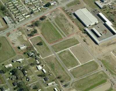
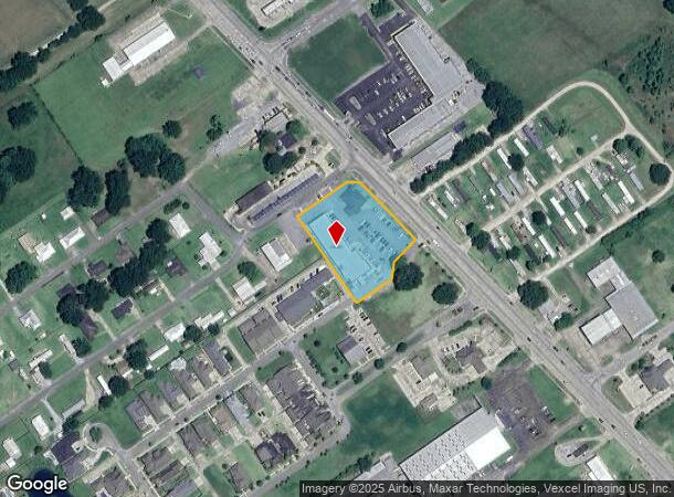
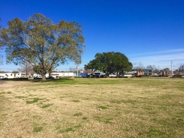
Property Record
1821 Rees St, Breaux Bridge, LA 70517
NEARBY LISTINGS FOR SALE OR LEASE
-
-
View all Breaux Bridge listings for sale on LoopNet.com
Property Detail
1821 Rees St
06901A0865
Park Place
Commercialnec
1.644 AC TRACT 5 PER PLAT OF SURVEY #442943COB 1584-129-442943 1590-468-445329 1852-353-547940
X
St Martin
22055C0100J
Louisiana
2024
1.64 AC
2024
St Martin Parish
020502
Lafayette
14,178 SF
Lafayette, LA
DEMOGRAPHICS near 1821 Rees St
1 mile
3 mile
5 mile
2024 Total Population
2,466
12,831
22,333
2029 Population
2,413
12,622
22,146
Pop Growth 2024-2029
(2.15%)
(1.63%)
(0.84%)
Average Age
38
39
39
2024 Total Households
946
5,017
8,630
HH Growth 2024-2029
(1.90%)
(1.49%)
(0.76%)
Median Household Inc
$55,624
$51,321
$52,939
Avg Household Size
2.50
2.50
2.50
2024 Avg HH Vehicles
2.00
2.00
2.00
Median Home Value
$171,372
$169,542
$169,516
Median Year Built
1987
1986
1986
Nearby Places
Map Layers
Map Styles
 Street
 Aerial
Transit
 Traffic
 Biking
Places
Listings with unknown addresses are not visible on the map
- Restaurants
- Banks
- Shops
- Fitness
- Groceries
PUBLIC TRANSPORTATION
COMMUTER RAIL
Drive
Walk
Distance
14 min
9.4 mi
AIRPORT
Lafayette Regional/Paul Fournet Field
Drive
Walk
Distance
Lafayette Regional/Paul Fournet Field
17 min
10.3 mi
Freight Ports
Port of Iberia
Drive
Walk
Distance
Port of Iberia
44 min
32.4 mi
SALE & LEASE HISTORY
LISTING DATE
SALE/LEASE

Feb 01, 2018
For Sale
Nearby Properties
Address
Land Use
TOTAL SIZE
Lot Size
Zoning
Address
Land Use
TOTAL SIZE
Lot Size
Zoning
Address
Land Use
TOTAL SIZE
Lot Size
Zoning
180,130 SF
22.92 AC
Address
Land Use
TOTAL SIZE
Lot Size
Zoning
Address
Land Use
TOTAL SIZE
Lot Size
Zoning
Address
Land Use
TOTAL SIZE
Lot Size
Zoning
9,000 SF
10.80 AC
Address
Land Use
TOTAL SIZE
Lot Size
Zoning
12,000 SF
11.29 AC
Address
Land Use
TOTAL SIZE
Lot Size
Zoning
Address
Land Use
TOTAL SIZE
Lot Size
Zoning
4,000 SF
11.41 AC
Address
Land Use
TOTAL SIZE
Lot Size
Zoning
30,900 SF
3.18 AC
Address
Land Use
TOTAL SIZE
Lot Size
Zoning
41,334 SF
6.34 AC
Address
Land Use
TOTAL SIZE
Lot Size
Zoning
12,047 SF
2.41 AC
Address
Land Use
TOTAL SIZE
Lot Size
Zoning
44,026 SF
5.06 AC
Address
Land Use
TOTAL SIZE
Lot Size
Zoning
15,540 SF
7.78 AC
Address
Land Use
TOTAL SIZE
Lot Size
Zoning
38,656 SF
6 AC
Address
Land Use
TOTAL SIZE
Lot Size
Zoning
Address
Land Use
TOTAL SIZE
Lot Size
Zoning
8,180 SF
2.57 AC
Address
Land Use
TOTAL SIZE
Lot Size
Zoning
2,485 SF
4.83 AC
Address
Land Use
TOTAL SIZE
Lot Size
Zoning
Address
Land Use
TOTAL SIZE
Lot Size
Zoning
Address
Land Use
TOTAL SIZE
Lot Size
Zoning
2,577 SF
0.30 AC
Address
Land Use
TOTAL SIZE
Lot Size
Zoning
10,194 SF
2.81 AC
Address
Land Use
TOTAL SIZE
Lot Size
Zoning
2,568 SF
4.79 AC
Address
Land Use
TOTAL SIZE
Lot Size
Zoning
120,000 SF
18.99 AC
Address
Land Use
TOTAL SIZE
Lot Size
Zoning
7,098 SF
6.26 AC
Address
Land Use
TOTAL SIZE
Lot Size
Zoning
30,000 SF
7.56 AC
Address
Land Use
TOTAL SIZE
Lot Size
Zoning
2,844 SF
Address
Land Use
TOTAL SIZE
Lot Size
Zoning
14,719 SF
1.69 AC
Address
Land Use
TOTAL SIZE
Lot Size
Zoning
1,100 SF
0.28 AC
Address
Land Use
TOTAL SIZE
Lot Size
Zoning
2,625 SF
1.25 AC
The World's #1 Commercial Real Estate Marketplace
Connect with us
© 2026 CoStar Group
The information above has been obtained from sources believed reliable. While we do not doubt its accuracy we have not verified it and make no guarantee, warranty or representation about it. It is your responsibility to independently confirm its accuracy and completeness. Any projections, opinions, assumptions, or estimates used are for example only and do not represent the current or future performance of the property. The value of this transaction to you depends on tax and other factors which should be evaluated by your tax, financial, and legal advisors. You and your advisors should conduct a careful, independent investigation of the property to determine to your satisfaction the suitability of the property for your needs.