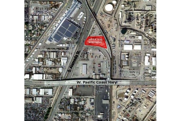
Property Record
1815 E O St, Wilmington, CA 90744

Current Lease Availabilities
Property Detail
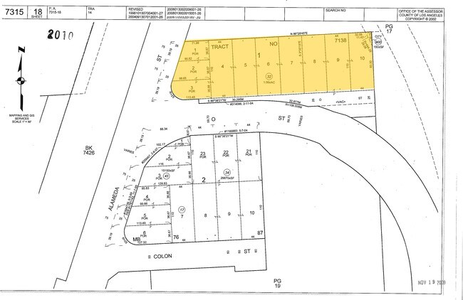
1815 E O St
7315-018-032
TR=7138 POR VAC ST,EX OF STS LOTS 1,2,3, ALL OF LOTS 4 TO 9, POR OF LOT 10 BLK 1
Industrialgeneral
LOS ANGELES
LAM3
California
B and X Area of moderate flood hazard, usually the area between the limits of the 100-year and 500-year floods.
2
2024
1.06 AC
2025
Long Beach: Suburban
980014
Los Angeles
1,800 SF
Los Angeles-Long Beach-Glendale, CA
NEARBY LISTINGS FOR SALE OR LEASE
DEMOGRAPHICS near 1815 E O St
1 mile
3 mile
5 mile
2025 Total Population
7,618
175,774
513,193
2030 Population
7,490
173,516
509,278
Pop Growth 2025-2030
(1.68%)
(1.28%)
(0.76%)
Average Age
38
39
40
2025 Total Households
1,957
51,663
173,635
HH Growth 2025-2030
(1.79%)
(1.43%)
(0.80%)
Median Household Inc
$64,375
$73,204
$80,049
Avg Household Size
3.50
3.20
2.80
2025 Avg HH Vehicles
2.00
2.00
2.00
Median Home Value
$685,557
$688,229
$724,844
Median Year Built
1964
1960
1964
Nearby Places
Map Layers
Map Styles
 Street
 Aerial
Layers
 Traffic
 Biking
Places
Listings with unknown addresses are not visible on the map
- Restaurants
- Banks
- Shops
- Fitness
- Groceries
PUBLIC TRANSPORTATION
AIRPORT
Long Beach (Daugherty Field)
Drive
Walk
Distance
Long Beach (Daugherty Field)
12 min
6.7 mi
Los Angeles International
Drive
Walk
Distance
Los Angeles International
26 min
18.8 mi
John Wayne/Orange County
Drive
Walk
Distance
John Wayne/Orange County
34 min
26.9 mi
Freight Ports
Port of Long Beach
Drive
Walk
Distance
Port of Long Beach
10 min
4.6 mi
Nearby Properties
Address
Land Use
TOTAL SIZE
Lot Size
Zoning
Address
Land Use
TOTAL SIZE
Lot Size
Zoning
236,582 SF
425.41 AC
CAMH*
Address
Land Use
TOTAL SIZE
Lot Size
Zoning
845,760 SF
4.01 AC
LBPD6
Address
Land Use
TOTAL SIZE
Lot Size
Zoning
617,114 SF
3.53 AC
LBPD
Address
Land Use
TOTAL SIZE
Lot Size
Zoning
918,344 SF
4.14 AC
LBPD30
Address
Land Use
TOTAL SIZE
Lot Size
Zoning
56,300 SF
116.80 AC
LAM3
Address
Land Use
TOTAL SIZE
Lot Size
Zoning
5,086 SF
255.48 AC
LAM3
Address
Land Use
TOTAL SIZE
Lot Size
Zoning
182,749 SF
LBPD30
Address
Land Use
TOTAL SIZE
Lot Size
Zoning
286,186 SF
8.20 AC
LAMR1
Address
Land Use
TOTAL SIZE
Lot Size
Zoning
108,891 SF
224.14 AC
CAMH*
Address
Land Use
TOTAL SIZE
Lot Size
Zoning
119,356 SF
3.86 AC
LAM2
Address
Land Use
TOTAL SIZE
Lot Size
Zoning
246,981 SF
11.95 AC
LARD2
Address
Land Use
TOTAL SIZE
Lot Size
Zoning
285,314 SF
14.28 AC
CAMH*
Address
Land Use
TOTAL SIZE
Lot Size
Zoning
84,365 SF
7.62 AC
LARAS3
Address
Land Use
TOTAL SIZE
Lot Size
Zoning
513,520 SF
19.09 AC
LBPD26
Address
Land Use
TOTAL SIZE
Lot Size
Zoning
311,796 SF
1.90 AC
LBPD30
Address
Land Use
TOTAL SIZE
Lot Size
Zoning
113,919 SF
0.72 AC
LBPD30
Address
Land Use
TOTAL SIZE
Lot Size
Zoning
194,230 SF
2.58 AC
LBR4N
Address
Land Use
TOTAL SIZE
Lot Size
Zoning
1,800 SF
124.45 AC
CAMH*
Address
Land Use
TOTAL SIZE
Lot Size
Zoning
174,910 SF
131.43 AC
LAM3
Address
Land Use
TOTAL SIZE
Lot Size
Zoning
213,408 SF
13.81 AC
LBR4R
Address
Land Use
TOTAL SIZE
Lot Size
Zoning
350,896 SF
13.43 AC
LBML*
Address
Land Use
TOTAL SIZE
Lot Size
Zoning
135,666 SF
LAM3
Address
Land Use
TOTAL SIZE
Lot Size
Zoning
14.80 AC
CAMH*
Address
Land Use
TOTAL SIZE
Lot Size
Zoning
84,054 SF
0.34 AC
LBPD
Address
Land Use
TOTAL SIZE
Lot Size
Zoning
10.30 AC
TOM2*
Address
Land Use
TOTAL SIZE
Lot Size
Zoning
238,914 SF
12.97 AC
LBIP
Address
Land Use
TOTAL SIZE
Lot Size
Zoning
169,056 SF
10.04 AC
LBR4R
Address
Land Use
TOTAL SIZE
Lot Size
Zoning
225,486 SF
2.26 AC
LBPD6
Address
Land Use
TOTAL SIZE
Lot Size
Zoning
496,472 SF
21.57 AC
CAMH*
Address
Land Use
TOTAL SIZE
Lot Size
Zoning
133,846 SF
1.18 AC
LBPD29
The World's #1 Commercial Real Estate Marketplace
Connect with us
© 2026 CoStar Group
The information above has been obtained from sources believed reliable. While we do not doubt its accuracy we have not verified it and make no guarantee, warranty or representation about it. It is your responsibility to independently confirm its accuracy and completeness. Any projections, opinions, assumptions, or estimates used are for example only and do not represent the current or future performance of the property. The value of this transaction to you depends on tax and other factors which should be evaluated by your tax, financial, and legal advisors. You and your advisors should conduct a careful, independent investigation of the property to determine to your satisfaction the suitability of the property for your needs.