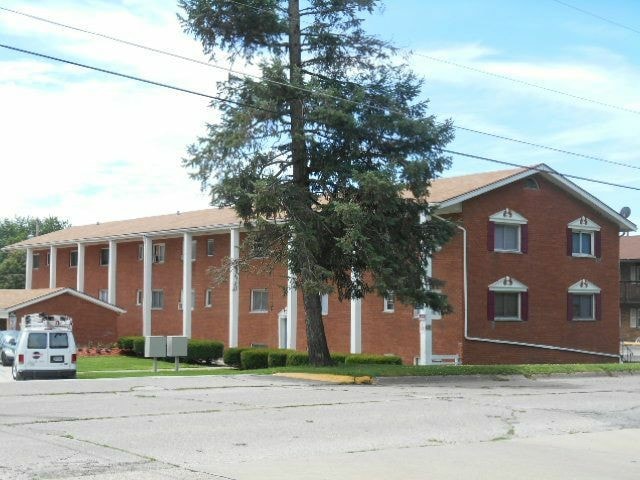
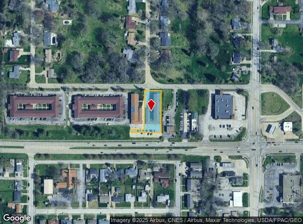
Property Record
1815 W 40Th St, Davenport, IA 52806
NEARBY LISTINGS FOR SALE OR LEASE
Property Detail
1815 W 40Th St
M1507-29C
Section 15
Apartment
SEC:15 TWP:78 RNG:03PT OF NW/4 SEC15-78-3 COM AT SECOR NW/4-N 340.5' -W560' TO PT OF BEG-CONT W 95'-S 230' -W 85' -S 15' -E
X
Scott
19163C0365H
Iowa
2025
0.56 AC
2025
North Side
012701
Davenport/Moline/Rock Island
15,567 SF
Davenport-Moline-Rock Island, IA-IL
DEMOGRAPHICS near 1815 W 40Th St
1 Mile
3 Mile
5 Mile
2024 Total Population
10,628
75,715
122,963
2029 Population
10,569
75,364
122,318
Pop Growth 2024-2029
(0.56%)
(0.46%)
(0.52%)
Average Age
43
39
39
2024 Total Households
4,574
31,256
51,155
HH Growth 2024-2029
(0.59%)
(0.44%)
(0.53%)
Median Household Inc
$60,899
$53,609
$54,973
Avg Household Size
2.30
2.30
2.30
2024 Avg HH Vehicles
2.00
2.00
2.00
Median Home Value
$164,432
$146,286
$152,021
Median Year Built
1968
1964
1963
Nearby Places
Map Layers
Map Styles
 Street
 Aerial
- Restaurants
- Banks
- Shops
- Fitness
- Groceries
PUBLIC TRANSPORTATION
AIRPORT
Quad Cities International
DRIVE
WALK
Distance
Quad Cities International
26 min
13.2 mi
Freight Ports
Port Milwaukee
DRIVE
WALK
Distance
Port Milwaukee
244 min
214.0 mi
SALE & LEASE HISTORY
LISTING DATE
SALE/LEASE

Dec 22, 2017
For Sale
Nearby Properties
Address
Land Use
TOTAL SIZE
Lot Size
Zoning
Address
Land Use
TOTAL SIZE
Lot Size
Zoning
7,934 SF
8.41 AC
Address
Land Use
TOTAL SIZE
Lot Size
Zoning
3,516 SF
26.74 AC
Address
Land Use
TOTAL SIZE
Lot Size
Zoning
197,194 SF
5.14 AC
Address
Land Use
TOTAL SIZE
Lot Size
Zoning
253,608 SF
9.29 AC
Address
Land Use
TOTAL SIZE
Lot Size
Zoning
27,225 SF
40.34 AC
Address
Land Use
TOTAL SIZE
Lot Size
Zoning
27,306 SF
50.57 AC
Address
Land Use
TOTAL SIZE
Lot Size
Zoning
300,718 SF
14.71 AC
Address
Land Use
TOTAL SIZE
Lot Size
Zoning
63,359 SF
12.01 AC
Address
Land Use
TOTAL SIZE
Lot Size
Zoning
352,332 SF
34.16 AC
Address
Land Use
TOTAL SIZE
Lot Size
Zoning
472,569 SF
47.24 AC
Address
Land Use
TOTAL SIZE
Lot Size
Zoning
61,623 SF
2.18 AC
Address
Land Use
TOTAL SIZE
Lot Size
Zoning
76,853 SF
0.56 AC
Address
Land Use
TOTAL SIZE
Lot Size
Zoning
25,176 SF
13.85 AC
Address
Land Use
TOTAL SIZE
Lot Size
Zoning
77,187 SF
0.88 AC
Address
Land Use
TOTAL SIZE
Lot Size
Zoning
27,312 SF
15.04 AC
Address
Land Use
TOTAL SIZE
Lot Size
Zoning
70,098 SF
9.72 AC
Address
Land Use
TOTAL SIZE
Lot Size
Zoning
8,000 SF
4.59 AC
Address
Land Use
TOTAL SIZE
Lot Size
Zoning
197,946 SF
18.64 AC
Address
Land Use
TOTAL SIZE
Lot Size
Zoning
96,529 SF
3.52 AC
Address
Land Use
TOTAL SIZE
Lot Size
Zoning
4,800 SF
18.86 AC
Address
Land Use
TOTAL SIZE
Lot Size
Zoning
86,976 SF
40 AC
Address
Land Use
TOTAL SIZE
Lot Size
Zoning
99,540 SF
10.95 AC
Address
Land Use
TOTAL SIZE
Lot Size
Zoning
111,452 SF
40 AC
Address
Land Use
TOTAL SIZE
Lot Size
Zoning
12,648 SF
8.28 AC
Address
Land Use
TOTAL SIZE
Lot Size
Zoning
50,880 SF
11.36 AC
Address
Land Use
TOTAL SIZE
Lot Size
Zoning
54,644 SF
2.41 AC
Address
Land Use
TOTAL SIZE
Lot Size
Zoning
213,686 SF
23.29 AC
Address
Land Use
TOTAL SIZE
Lot Size
Zoning
10,724 SF
1.51 AC
Address
Land Use
TOTAL SIZE
Lot Size
Zoning
3,000 SF
59.92 AC
Address
Land Use
TOTAL SIZE
Lot Size
Zoning
348,893 SF
15.30 AC
The World's #1 Commercial Real Estate Marketplace
Connect with us
© 2025 CoStar Group
The information above has been obtained from sources believed reliable. While we do not doubt its accuracy we have not verified it and make no guarantee, warranty or representation about it. It is your responsibility to independently confirm its accuracy and completeness. Any projections, opinions, assumptions, or estimates used are for example only and do not represent the current or future performance of the property. The value of this transaction to you depends on tax and other factors which should be evaluated by your tax, financial, and legal advisors. You and your advisors should conduct a careful, independent investigation of the property to determine to your satisfaction the suitability of the property for your needs.