Property Record
1815 Ygnacio Valley Rd, Walnut Creek, CA 94598
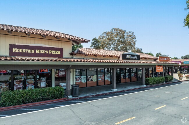

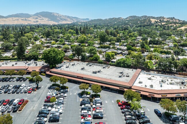
Property Detail
1815 Ygnacio Valley Rd
Oakland-Fremont-Berkeley, CA
PCL MAP 42 PG 36 POR PCL B
140-330-006-2
CONTRA COSTA
Regionalshoppingcenterormallwithanchorstore
California
B and X Area of moderate flood hazard, usually the area between the limits of the 100-year and 500-year floods.
4
2025
9.19 AC
2025
Walnut Creek-BART/DT
338302
East Bay/Oakland
34,944 SF
NEARBY LISTINGS FOR SALE OR LEASE
DEMOGRAPHICS near 1815 Ygnacio Valley Rd
1 mile
3 mile
5 mile
2025 Total Population
13,754
122,300
264,002
2030 Population
13,887
123,628
266,147
Pop Growth 2025-2030
+ 0.97%
+ 1.09%
+ 0.81%
Average Age
45
42
44
2025 Total Households
5,755
50,267
106,755
HH Growth 2025-2030
+ 1.04%
+ 1.29%
+ 0.97%
Median Household Inc
$175,143
$137,986
$130,007
Avg Household Size
2.30
2.40
2.40
2025 Avg HH Vehicles
2.00
2.00
2.00
Median Home Value
$1,051,497
$1,027,896
$962,396
Median Year Built
1973
1972
1972
Nearby Places
Map Layers
Map Styles
 Street
 Aerial
Layers
 Traffic
 Biking
Places
Listings with unknown addresses are not visible on the map
- Restaurants
- Banks
- Shops
- Fitness
- Groceries
PUBLIC TRANSPORTATION
AIRPORT
Metro Oakland International
Drive
Walk
Distance
Metro Oakland International
37 min
26.0 mi
San Francisco International
Drive
Walk
Distance
San Francisco International
55 min
37.9 mi
Freight Ports
Port of Oakland
Drive
Walk
Distance
Port of Oakland
27 min
18.8 mi
SALE & LEASE HISTORY
LISTING DATE
SALE/LEASE

Sep 25, 2016
For Lease
Nearby Properties
Address
Land Use
TOTAL SIZE
Lot Size
Zoning
Address
Land Use
TOTAL SIZE
Lot Size
Zoning
Address
Land Use
TOTAL SIZE
Lot Size
Zoning
13.66 AC
Address
Land Use
TOTAL SIZE
Lot Size
Zoning
428,476 SF
3.56 AC
Address
Land Use
TOTAL SIZE
Lot Size
Zoning
155,176 SF
3.34 AC
Address
Land Use
TOTAL SIZE
Lot Size
Zoning
295,561 SF
3.80 AC
Address
Land Use
TOTAL SIZE
Lot Size
Zoning
213,500 SF
3.02 AC
Address
Land Use
TOTAL SIZE
Lot Size
Zoning
337,980 SF
5.08 AC
Address
Land Use
TOTAL SIZE
Lot Size
Zoning
254,940 SF
1.61 AC
P1
Address
Land Use
TOTAL SIZE
Lot Size
Zoning
77,286 SF
3.68 AC
Address
Land Use
TOTAL SIZE
Lot Size
Zoning
174,951 SF
1.82 AC
Address
Land Use
TOTAL SIZE
Lot Size
Zoning
264,873 SF
2.19 AC
P1
Address
Land Use
TOTAL SIZE
Lot Size
Zoning
203,454 SF
2.33 AC
Address
Land Use
TOTAL SIZE
Lot Size
Zoning
5.52 AC
P1
Address
Land Use
TOTAL SIZE
Lot Size
Zoning
235,495 SF
2.51 AC
P1
Address
Land Use
TOTAL SIZE
Lot Size
Zoning
250,032 SF
7.95 AC
P1
Address
Land Use
TOTAL SIZE
Lot Size
Zoning
153,137 SF
1.22 AC
Address
Land Use
TOTAL SIZE
Lot Size
Zoning
393,680 SF
2.29 AC
Address
Land Use
TOTAL SIZE
Lot Size
Zoning
157,352 SF
0.98 AC
Address
Land Use
TOTAL SIZE
Lot Size
Zoning
249,628 SF
3.64 AC
P1
Address
Land Use
TOTAL SIZE
Lot Size
Zoning
118,596 SF
1.20 AC
Address
Land Use
TOTAL SIZE
Lot Size
Zoning
800,764 SF
3.66 AC
Address
Land Use
TOTAL SIZE
Lot Size
Zoning
192,387 SF
17.42 AC
M17
Address
Land Use
TOTAL SIZE
Lot Size
Zoning
12,864 SF
5.62 AC
Address
Land Use
TOTAL SIZE
Lot Size
Zoning
187,156 SF
5.92 AC
P1
Address
Land Use
TOTAL SIZE
Lot Size
Zoning
24,392 SF
2.29 AC
Address
Land Use
TOTAL SIZE
Lot Size
Zoning
321,000 SF
3.26 AC
Address
Land Use
TOTAL SIZE
Lot Size
Zoning
38,027 SF
2.86 AC
Address
Land Use
TOTAL SIZE
Lot Size
Zoning
237,656 SF
7.16 AC
P1
Address
Land Use
TOTAL SIZE
Lot Size
Zoning
166,144 SF
19.22 AC
Address
Land Use
TOTAL SIZE
Lot Size
Zoning
13,326 SF
6.84 AC
M-H
The World's #1 Commercial Real Estate Marketplace
Connect with us
© 2026 CoStar Group
The information above has been obtained from sources believed reliable. While we do not doubt its accuracy we have not verified it and make no guarantee, warranty or representation about it. It is your responsibility to independently confirm its accuracy and completeness. Any projections, opinions, assumptions, or estimates used are for example only and do not represent the current or future performance of the property. The value of this transaction to you depends on tax and other factors which should be evaluated by your tax, financial, and legal advisors. You and your advisors should conduct a careful, independent investigation of the property to determine to your satisfaction the suitability of the property for your needs.