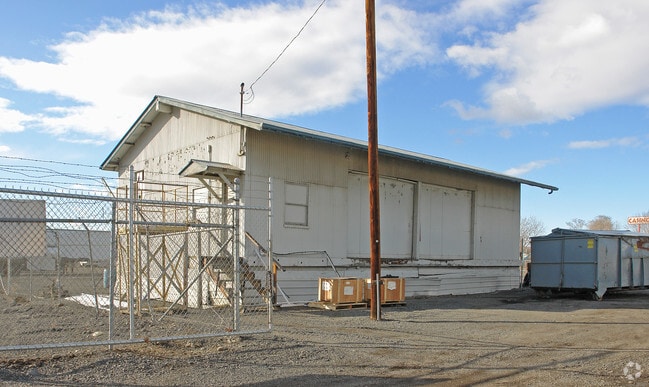
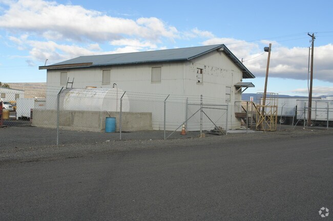
Property Record
1817 Birch St, Yakima, WA 98901
Property Detail
1817 Birch St
Yakima, WA
BELMONT ADD: LOT 12
191329-42425
YAKIMA
Parkinglot
Washington
M1
12
B and X Area of moderate flood hazard, usually the area between the limits of the 100-year and 500-year floods.
0.35 AC
2026
Greater Yakima
2026
Yakima
001602
NEARBY LISTINGS FOR SALE OR LEASE
DEMOGRAPHICS near 1817 Birch St
1 mile
3 mile
5 mile
2025 Total Population
4,749
59,450
98,845
2030 Population
4,769
59,804
99,526
Pop Growth 2025-2030
+ 0.42%
+ 0.60%
+ 0.69%
Average Age
32
35
37
2025 Total Households
1,414
20,066
35,520
HH Growth 2025-2030
+ 0.35%
+ 0.64%
+ 0.74%
Median Household Inc
$49,619
$52,149
$59,614
Avg Household Size
3.30
2.80
2.70
2025 Avg HH Vehicles
2.00
2.00
2.00
Median Home Value
$210,945
$231,152
$279,616
Median Year Built
1972
1968
1970
Nearby Places
Map Layers
Map Styles
 Street
 Aerial
Layers
 Traffic
 Biking
Places
Listings with unknown addresses are not visible on the map
- Restaurants
- Banks
- Shops
- Fitness
- Groceries
PUBLIC TRANSPORTATION
AIRPORT
Yakima Air Trml/McAllister Field
Drive
Walk
Distance
Yakima Air Trml/McAllister Field
9 min
4.1 mi
Freight Ports
Port of Tacoma
Drive
Walk
Distance
Port of Tacoma
184 min
157.0 mi
Nearby Properties
Address
Land Use
TOTAL SIZE
Lot Size
Zoning
Address
Land Use
TOTAL SIZE
Lot Size
Zoning
390,527 SF
11.86 AC
R3
Address
Land Use
TOTAL SIZE
Lot Size
Zoning
239,131 SF
36.70 AC
GC
Address
Land Use
TOTAL SIZE
Lot Size
Zoning
326,323 SF
30.05 AC
R2
Address
Land Use
TOTAL SIZE
Lot Size
Zoning
87,068 SF
2.89 AC
BCOM
Address
Land Use
TOTAL SIZE
Lot Size
Zoning
208,322 SF
3.69 AC
PUB
Address
Land Use
TOTAL SIZE
Lot Size
Zoning
176,098 SF
1.67 AC
BCOM
Address
Land Use
TOTAL SIZE
Lot Size
Zoning
106,878 SF
3.46 AC
RD
Address
Land Use
TOTAL SIZE
Lot Size
Zoning
329,388 SF
16.13 AC
M1
Address
Land Use
TOTAL SIZE
Lot Size
Zoning
129,042 SF
6.53 AC
R2
Address
Land Use
TOTAL SIZE
Lot Size
Zoning
82,436 SF
11 AC
RD
Address
Land Use
TOTAL SIZE
Lot Size
Zoning
121,488 SF
5.97 AC
R2
Address
Land Use
TOTAL SIZE
Lot Size
Zoning
345,698 SF
3.52 AC
C1
Address
Land Use
TOTAL SIZE
Lot Size
Zoning
91,856 SF
9.17 AC
RD
Address
Land Use
TOTAL SIZE
Lot Size
Zoning
100,992 SF
9.15 AC
RD
Address
Land Use
TOTAL SIZE
Lot Size
Zoning
56,505 SF
2.75 AC
GC
Address
Land Use
TOTAL SIZE
Lot Size
Zoning
64,171 SF
48.08 AC
PUB
Address
Land Use
TOTAL SIZE
Lot Size
Zoning
97,056 SF
5.80 AC
R2
Address
Land Use
TOTAL SIZE
Lot Size
Zoning
197,263 SF
18.08 AC
GC
Address
Land Use
TOTAL SIZE
Lot Size
Zoning
135,634 SF
9.84 AC
C1
Address
Land Use
TOTAL SIZE
Lot Size
Zoning
163,130 SF
1.95 AC
BCOM
Address
Land Use
TOTAL SIZE
Lot Size
Zoning
129,173 SF
6.65 AC
R3
Address
Land Use
TOTAL SIZE
Lot Size
Zoning
84,714 SF
4.40 AC
R2
Address
Land Use
TOTAL SIZE
Lot Size
Zoning
97,976 SF
3.98 AC
SCC
Address
Land Use
TOTAL SIZE
Lot Size
Zoning
89,850 SF
14.03 AC
R1
Address
Land Use
TOTAL SIZE
Lot Size
Zoning
80,374 SF
8.99 AC
C1
Address
Land Use
TOTAL SIZE
Lot Size
Zoning
114,406 SF
15.50 AC
PUB
Address
Land Use
TOTAL SIZE
Lot Size
Zoning
94,724 SF
0.79 AC
BCOM
Address
Land Use
TOTAL SIZE
Lot Size
Zoning
73,917 SF
1.01 AC
BCOM
Address
Land Use
TOTAL SIZE
Lot Size
Zoning
83,856 SF
4.23 AC
R2
Address
Land Use
TOTAL SIZE
Lot Size
Zoning
151,831 SF
21.08 AC
M1
The World's #1 Commercial Real Estate Marketplace
Connect with us
© 2026 CoStar Group
The information above has been obtained from sources believed reliable. While we do not doubt its accuracy we have not verified it and make no guarantee, warranty or representation about it. It is your responsibility to independently confirm its accuracy and completeness. Any projections, opinions, assumptions, or estimates used are for example only and do not represent the current or future performance of the property. The value of this transaction to you depends on tax and other factors which should be evaluated by your tax, financial, and legal advisors. You and your advisors should conduct a careful, independent investigation of the property to determine to your satisfaction the suitability of the property for your needs.