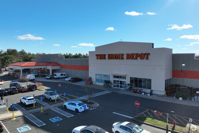
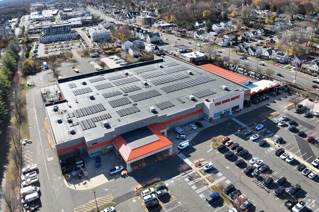
Property Record
1817 Dixwell Ave, Hamden, CT 06514

Property Detail
1817 Dixwell Ave
HAMD-002427-000171
NEW HAVEN
Commercialbuilding
Connecticut
T4
0000
B and X Area of moderate flood hazard, usually the area between the limits of the 100-year and 500-year floods.
8.93 AC
2024
Hamden
2025
Westchester/So Connecticut
165802
New Haven, CT
104,318 SF
NEARBY LISTINGS FOR SALE OR LEASE
DEMOGRAPHICS near 1817 Dixwell Ave
1 mile
3 mile
5 mile
2025 Total Population
14,706
85,239
218,173
2030 Population
14,951
85,917
219,884
Pop Growth 2025-2030
+ 1.67%
+ 0.80%
+ 0.78%
Average Age
42
39
38
2025 Total Households
6,673
33,513
85,500
HH Growth 2025-2030
+ 1.90%
+ 0.78%
+ 0.97%
Median Household Inc
$77,057
$77,581
$67,508
Avg Household Size
2.10
2.30
2.30
2025 Avg HH Vehicles
2.00
2.00
1.00
Median Home Value
$268,294
$297,230
$314,194
Median Year Built
1964
1958
1958
Nearby Places
Map Layers
Map Styles
 Street
 Aerial
Transit
 Traffic
 Biking
Places
Listings with unknown addresses are not visible on the map
- Restaurants
- Banks
- Shops
- Fitness
- Groceries
PUBLIC TRANSPORTATION
COMMUTER RAIL
New Haven-State Street Station (New Haven Line - Metro-North Commuter Railroad Company (Metro-North))
Drive
Walk
Distance
New Haven-State Street Station (New Haven Line - Metro-North Commuter Railroad Company (Metro-North))
10 min
4.6 mi
Drive
Walk
Distance
10 min
5.2 mi
AIRPORT
Tweed/New Haven
Drive
Walk
Distance
Tweed/New Haven
19 min
9.5 mi
Freight Ports
Port of New Haven
Drive
Walk
Distance
Port of New Haven
14 min
6.7 mi
Nearby Properties
Address
Land Use
TOTAL SIZE
Lot Size
Zoning
Address
Land Use
TOTAL SIZE
Lot Size
Zoning
33,122 SF
23.06 AC
T4
Address
Land Use
TOTAL SIZE
Lot Size
Zoning
8,758 SF
12.74 AC
IH
Address
Land Use
TOTAL SIZE
Lot Size
Zoning
111,274 SF
22.62 AC
CEM
Address
Land Use
TOTAL SIZE
Lot Size
Zoning
258,313 SF
23.50 AC
PDU 34
Address
Land Use
TOTAL SIZE
Lot Size
Zoning
9,767 SF
33.63 AC
RM1
Address
Land Use
TOTAL SIZE
Lot Size
Zoning
28,824 SF
44.93 AC
T4
Address
Land Use
TOTAL SIZE
Lot Size
Zoning
316,781 SF
9.20 AC
PDU 94
Address
Land Use
TOTAL SIZE
Lot Size
Zoning
15.32 AC
T4
Address
Land Use
TOTAL SIZE
Lot Size
Zoning
0.01 AC
T5
Address
Land Use
TOTAL SIZE
Lot Size
Zoning
78,878 SF
3.12 AC
RM2
Address
Land Use
TOTAL SIZE
Lot Size
Zoning
296,444 SF
23.30 AC
T145
Address
Land Use
TOTAL SIZE
Lot Size
Zoning
14.84 AC
T4
Address
Land Use
TOTAL SIZE
Lot Size
Zoning
30.46 AC
T5
Address
Land Use
TOTAL SIZE
Lot Size
Zoning
106,266 SF
5.51 AC
RM2
Address
Land Use
TOTAL SIZE
Lot Size
Zoning
60,374 SF
10.85 AC
T2
Address
Land Use
TOTAL SIZE
Lot Size
Zoning
6,784 SF
17.53 AC
RM1
Address
Land Use
TOTAL SIZE
Lot Size
Zoning
73,504 SF
7.97 AC
PDD 10
Address
Land Use
TOTAL SIZE
Lot Size
Zoning
78,579 SF
6.07 AC
RM2
Address
Land Use
TOTAL SIZE
Lot Size
Zoning
4,334 SF
70 AC
PARK
Address
Land Use
TOTAL SIZE
Lot Size
Zoning
143,428 SF
13.08 AC
T4
Address
Land Use
TOTAL SIZE
Lot Size
Zoning
116.04 AC
R3
Address
Land Use
TOTAL SIZE
Lot Size
Zoning
17.71 AC
IL80
Address
Land Use
TOTAL SIZE
Lot Size
Zoning
18.85 AC
T5
Address
Land Use
TOTAL SIZE
Lot Size
Zoning
25,015 SF
28.30 AC
RS2
Address
Land Use
TOTAL SIZE
Lot Size
Zoning
81,010 SF
4.82 AC
RM2
Address
Land Use
TOTAL SIZE
Lot Size
Zoning
57,467 SF
3.72 AC
T4
Address
Land Use
TOTAL SIZE
Lot Size
Zoning
92,126 SF
4.32 AC
RM2
Address
Land Use
TOTAL SIZE
Lot Size
Zoning
23.48 AC
T5
Address
Land Use
TOTAL SIZE
Lot Size
Zoning
10.91 AC
R5
Address
Land Use
TOTAL SIZE
Lot Size
Zoning
10.77 AC
R5
The World's #1 Commercial Real Estate Marketplace
Connect with us
© 2026 CoStar Group
The information above has been obtained from sources believed reliable. While we do not doubt its accuracy we have not verified it and make no guarantee, warranty or representation about it. It is your responsibility to independently confirm its accuracy and completeness. Any projections, opinions, assumptions, or estimates used are for example only and do not represent the current or future performance of the property. The value of this transaction to you depends on tax and other factors which should be evaluated by your tax, financial, and legal advisors. You and your advisors should conduct a careful, independent investigation of the property to determine to your satisfaction the suitability of the property for your needs.