Property Record
1817 E 10Th St, Bloomington, IN 47408
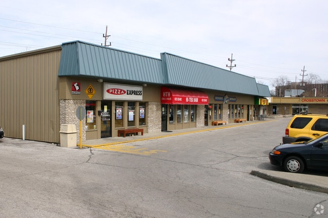
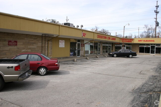
Property Detail
1817 E 10Th St
Bloomington, IN
013-35080-00 RAY ROGERS PART LOT 15 (W 70') & PT SE NW 34-9-1W 0.04 A
53-05-34-204-006.000-005
MONROE
Privateschool
Indiana
B and X Area of moderate flood hazard, usually the area between the limits of the 100-year and 500-year floods.
15
0
0.27 AC
2025
Downtown Bloomington IN
000202
Other Market Areas
5,212 SF
NEARBY LISTINGS FOR SALE OR LEASE
DEMOGRAPHICS near 1817 E 10Th St
1 mile
3 mile
5 mile
2025 Total Population
25,271
81,104
107,420
2030 Population
26,682
82,343
107,762
Pop Growth 2025-2030
+ 5.58%
+ 1.53%
+ 0.32%
Average Age
26
33
35
2025 Total Households
6,556
33,162
44,569
HH Growth 2025-2030
+ 9.18%
+ 1.55%
+ 0.22%
Median Household Inc
$33,270
$45,685
$53,418
Avg Household Size
2.00
2.00
2.10
2025 Avg HH Vehicles
2.00
2.00
2.00
Median Home Value
$334,193
$336,059
$315,197
Median Year Built
2007
1989
1989
Nearby Places
Map Layers
Map Styles
 Street
 Aerial
Layers
 Traffic
 Biking
Places
Listings with unknown addresses are not visible on the map
- Restaurants
- Banks
- Shops
- Fitness
- Groceries
Nearby Properties
Address
Land Use
TOTAL SIZE
Lot Size
Zoning
Address
Land Use
TOTAL SIZE
Lot Size
Zoning
7,804 SF
7.22 AC
Address
Land Use
TOTAL SIZE
Lot Size
Zoning
442,250 SF
37.15 AC
Address
Land Use
TOTAL SIZE
Lot Size
Zoning
Address
Land Use
TOTAL SIZE
Lot Size
Zoning
13,910 SF
3.86 AC
Address
Land Use
TOTAL SIZE
Lot Size
Zoning
8,107 SF
12.37 AC
Address
Land Use
TOTAL SIZE
Lot Size
Zoning
79,763 SF
12.34 AC
Address
Land Use
TOTAL SIZE
Lot Size
Zoning
8,327 SF
1.64 AC
Address
Land Use
TOTAL SIZE
Lot Size
Zoning
496,556 SF
1.73 AC
Address
Land Use
TOTAL SIZE
Lot Size
Zoning
Address
Land Use
TOTAL SIZE
Lot Size
Zoning
261,278 SF
4.62 AC
Address
Land Use
TOTAL SIZE
Lot Size
Zoning
3,593 SF
2.43 AC
Address
Land Use
TOTAL SIZE
Lot Size
Zoning
10,573 SF
3.28 AC
Address
Land Use
TOTAL SIZE
Lot Size
Zoning
8,064 SF
1.29 AC
Address
Land Use
TOTAL SIZE
Lot Size
Zoning
3,934 SF
21.23 AC
Address
Land Use
TOTAL SIZE
Lot Size
Zoning
5,908 SF
19.52 AC
Address
Land Use
TOTAL SIZE
Lot Size
Zoning
2,000 SF
6.74 AC
Address
Land Use
TOTAL SIZE
Lot Size
Zoning
169,170 SF
0.72 AC
Address
Land Use
TOTAL SIZE
Lot Size
Zoning
5,482 SF
17.05 AC
RE25
Address
Land Use
TOTAL SIZE
Lot Size
Zoning
4,895 SF
16.61 AC
Address
Land Use
TOTAL SIZE
Lot Size
Zoning
404,051 SF
36.54 AC
Address
Land Use
TOTAL SIZE
Lot Size
Zoning
134,566 SF
0.60 AC
Address
Land Use
TOTAL SIZE
Lot Size
Zoning
30,919 SF
8.91 AC
Address
Land Use
TOTAL SIZE
Lot Size
Zoning
137,362 SF
30.08 AC
Address
Land Use
TOTAL SIZE
Lot Size
Zoning
181,798 SF
0.80 AC
Address
Land Use
TOTAL SIZE
Lot Size
Zoning
7,500 SF
0.40 AC
Address
Land Use
TOTAL SIZE
Lot Size
Zoning
8,190 SF
4.22 AC
Address
Land Use
TOTAL SIZE
Lot Size
Zoning
17,016 SF
23.82 AC
Address
Land Use
TOTAL SIZE
Lot Size
Zoning
38,208 SF
8.03 AC
Address
Land Use
TOTAL SIZE
Lot Size
Zoning
8,439 SF
18.94 AC
Address
Land Use
TOTAL SIZE
Lot Size
Zoning
17,312 SF
31.90 AC
The World's #1 Commercial Real Estate Marketplace
Connect with us
© 2026 CoStar Group
The information above has been obtained from sources believed reliable. While we do not doubt its accuracy we have not verified it and make no guarantee, warranty or representation about it. It is your responsibility to independently confirm its accuracy and completeness. Any projections, opinions, assumptions, or estimates used are for example only and do not represent the current or future performance of the property. The value of this transaction to you depends on tax and other factors which should be evaluated by your tax, financial, and legal advisors. You and your advisors should conduct a careful, independent investigation of the property to determine to your satisfaction the suitability of the property for your needs.