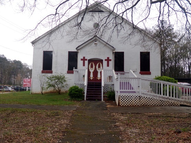
Property Record
2490 Perry Blvd Nw, Atlanta, GA 30318
NEARBY LISTINGS FOR SALE OR LEASE
Property Detail
2490 Perry Blvd Nw
Atlanta-Sandy Springs-Roswell, GA
Fulton
17-0251-0003-041-1
Georgia
Townhouserowhouse
0.05 AC
X
West Atlanta
13121C0236F
Atlanta
1,338 SF
DEMOGRAPHICS near 2490 Perry Blvd Nw
1 Mile
3 Mile
5 Mile
2024 Total Population
7,231
66,088
241,798
2029 Population
7,496
69,036
251,222
Pop Growth 2024-2029
+ 3.66%
+ 4.46%
+ 3.90%
Average Age
35
37
37
2024 Total Households
2,986
29,247
105,894
HH Growth 2024-2029
+ 3.75%
+ 4.43%
+ 4.07%
Median Household Inc
$68,576
$83,898
$78,507
Avg Household Size
2.30
2.20
2.10
2024 Avg HH Vehicles
1.00
1.00
1.00
Median Home Value
$355,414
$360,461
$389,784
Median Year Built
1974
1994
1992
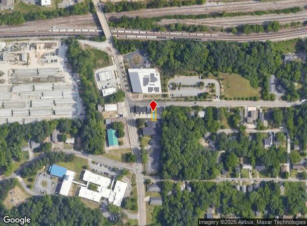
Nearby Places
Map Layers
Map Styles
 Street
 Aerial
- Restaurants
- Banks
- Shops
- Fitness
- Groceries
PUBLIC TRANSPORTATION
COMMUTER RAIL
DRIVE
WALK
Distance
15 min
6.4 mi
AIRPORT
Hartsfield - Jackson Atlanta International
DRIVE
WALK
Distance
Hartsfield - Jackson Atlanta International
29 min
17.3 mi
SALE & LEASE HISTORY
LISTING DATE
SALE/LEASE

Jan 10, 2020
For Sale
Apr 06, 2018
For Sale
Nearby Properties
Address
Land Use
TOTAL SIZE
Lot Size
Zoning
Address
Land Use
TOTAL SIZE
Lot Size
Zoning
485,185 SF
3.76 AC
I2
Address
Land Use
TOTAL SIZE
Lot Size
Zoning
173,430 SF
13.83 AC
PVC
Address
Land Use
TOTAL SIZE
Lot Size
Zoning
467,671 SF
4.82 AC
C1
Address
Land Use
TOTAL SIZE
Lot Size
Zoning
296,698 SF
8.99 AC
RG2
Address
Land Use
TOTAL SIZE
Lot Size
Zoning
16,408 SF
8.97 AC
PVC
Address
Land Use
TOTAL SIZE
Lot Size
Zoning
418,096 SF
7.73 AC
I2
Address
Land Use
TOTAL SIZE
Lot Size
Zoning
520,886 SF
9.96 AC
I2
Address
Land Use
TOTAL SIZE
Lot Size
Zoning
354,766 SF
11.32 AC
RG3
Address
Land Use
TOTAL SIZE
Lot Size
Zoning
549,094 SF
6.26 AC
I2
Address
Land Use
TOTAL SIZE
Lot Size
Zoning
3.25 AC
MU
Address
Land Use
TOTAL SIZE
Lot Size
Zoning
695,481 SF
11.66 AC
RG3
Address
Land Use
TOTAL SIZE
Lot Size
Zoning
1,770,090 SF
23.90 AC
RG2
Address
Land Use
TOTAL SIZE
Lot Size
Zoning
354,710 SF
25.27 AC
R5
Address
Land Use
TOTAL SIZE
Lot Size
Zoning
115 AC
I2
Address
Land Use
TOTAL SIZE
Lot Size
Zoning
329,385 SF
15.29 AC
RHR
Address
Land Use
TOTAL SIZE
Lot Size
Zoning
1,151,446 SF
I2
Address
Land Use
TOTAL SIZE
Lot Size
Zoning
439,167 SF
41.13 AC
RM-12
Address
Land Use
TOTAL SIZE
Lot Size
Zoning
281,632 SF
27.12 AC
RM-12
Address
Land Use
TOTAL SIZE
Lot Size
Zoning
403,687 SF
42.37 AC
RM-12
Address
Land Use
TOTAL SIZE
Lot Size
Zoning
538,535 SF
32.40 AC
I2
Address
Land Use
TOTAL SIZE
Lot Size
Zoning
499,198 SF
9.49 AC
RG3
Address
Land Use
TOTAL SIZE
Lot Size
Zoning
415,834 SF
17.62 AC
I2
Address
Land Use
TOTAL SIZE
Lot Size
Zoning
563,551 SF
13.98 AC
RG2C
Address
Land Use
TOTAL SIZE
Lot Size
Zoning
307,837 SF
3.43 AC
PVC
Address
Land Use
TOTAL SIZE
Lot Size
Zoning
1,057,380 SF
17.43 AC
C1
Address
Land Use
TOTAL SIZE
Lot Size
Zoning
59.28 AC
I1
Address
Land Use
TOTAL SIZE
Lot Size
Zoning
263,676 SF
15.70 AC
RM-12
Address
Land Use
TOTAL SIZE
Lot Size
Zoning
68.38 AC
R2
Address
Land Use
TOTAL SIZE
Lot Size
Zoning
285.03 AC
I2
Address
Land Use
TOTAL SIZE
Lot Size
Zoning
19.31 AC
R4
The World's #1 Commercial Real Estate Marketplace
Connect with us
© 2025 CoStar Group
The information above has been obtained from sources believed reliable. While we do not doubt its accuracy we have not verified it and make no guarantee, warranty or representation about it. It is your responsibility to independently confirm its accuracy and completeness. Any projections, opinions, assumptions, or estimates used are for example only and do not represent the current or future performance of the property. The value of this transaction to you depends on tax and other factors which should be evaluated by your tax, financial, and legal advisors. You and your advisors should conduct a careful, independent investigation of the property to determine to your satisfaction the suitability of the property for your needs.