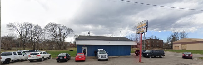
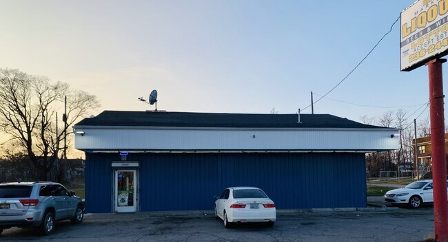
Property Record
1817 N Saginaw St, Flint, MI 48505

NEARBY LISTINGS FOR SALE OR LEASE
Property Detail
1817 N Saginaw St
Flint, MI
Pomeroy Bonbright Third Addition
40-01-484-011
POMEROY-BONBRIGHT 3RD ADDITION LOTS 60 THRU 64 INCL. COMB ON 12/05/2005 FROM 40-01-484-007, 40-01-484-008, 40-01-484-010;
Commercialnec
Genesee
X
Michigan
26049C0187D
60-64
2024
0.76 AC
2025
Flint
001100
Detroit
1,748 SF
DEMOGRAPHICS near 1817 N Saginaw St
1 Mile
3 Mile
5 Mile
2024 Total Population
9,300
86,145
154,153
2029 Population
9,808
88,642
155,545
Pop Growth 2024-2029
+ 5.46%
+ 2.90%
+ 0.90%
Average Age
41
39
39
2024 Total Households
3,866
35,966
64,144
HH Growth 2024-2029
+ 5.33%
+ 2.89%
+ 0.84%
Median Household Inc
$22,834
$33,401
$36,466
Avg Household Size
2.20
2.20
2.30
2024 Avg HH Vehicles
1.00
1.00
1.00
Median Home Value
$68,533
$62,716
$72,853
Median Year Built
1964
1957
1959
Nearby Places
Map Layers
Map Styles
 Street
 Aerial
- Restaurants
- Banks
- Shops
- Fitness
- Groceries
PUBLIC TRANSPORTATION
COMMUTER RAIL
Flint Amtrak Station (Blue Water - Amtrak)
DRIVE
WALK
Distance
Flint Amtrak Station (Blue Water - Amtrak)
8 min
3.7 mi
AIRPORT
Bishop International
DRIVE
WALK
Distance
Bishop International
23 min
11.0 mi
Freight Ports
Port of Toledo
DRIVE
WALK
Distance
Port of Toledo
139 min
116.8 mi
SALE & LEASE HISTORY
LISTING DATE
SALE/LEASE

Jan 18, 2023
For Sale
Nearby Properties
Address
Land Use
TOTAL SIZE
Lot Size
Zoning
Address
Land Use
TOTAL SIZE
Lot Size
Zoning
290,267 SF
79 AC
PC
Address
Land Use
TOTAL SIZE
Lot Size
Zoning
54,651 SF
3.06 AC
Address
Land Use
TOTAL SIZE
Lot Size
Zoning
130,291 SF
Address
Land Use
TOTAL SIZE
Lot Size
Zoning
571,389 SF
584 AC
Address
Land Use
TOTAL SIZE
Lot Size
Zoning
144,896 SF
0.23 AC
DC
Address
Land Use
TOTAL SIZE
Lot Size
Zoning
115,556 SF
2.50 AC
DE
Address
Land Use
TOTAL SIZE
Lot Size
Zoning
59,232 SF
3.65 AC
Address
Land Use
TOTAL SIZE
Lot Size
Zoning
329,849 SF
21.20 AC
CE
Address
Land Use
TOTAL SIZE
Lot Size
Zoning
247,555 SF
198 AC
Address
Land Use
TOTAL SIZE
Lot Size
Zoning
68,571 SF
0.81 AC
DC
Address
Land Use
TOTAL SIZE
Lot Size
Zoning
156,250 SF
Address
Land Use
TOTAL SIZE
Lot Size
Zoning
290,502 SF
272.83 AC
Address
Land Use
TOTAL SIZE
Lot Size
Zoning
10,212 SF
2.60 AC
UC
Address
Land Use
TOTAL SIZE
Lot Size
Zoning
182,408 SF
Address
Land Use
TOTAL SIZE
Lot Size
Zoning
85,697 SF
0.30 AC
DC
Address
Land Use
TOTAL SIZE
Lot Size
Zoning
123,170 SF
3.41 AC
DE
Address
Land Use
TOTAL SIZE
Lot Size
Zoning
Address
Land Use
TOTAL SIZE
Lot Size
Zoning
65,488 SF
0.30 AC
DC
Address
Land Use
TOTAL SIZE
Lot Size
Zoning
203,200 SF
0.92 AC
DE
Address
Land Use
TOTAL SIZE
Lot Size
Zoning
44,864 SF
5.54 AC
Address
Land Use
TOTAL SIZE
Lot Size
Zoning
74,816 SF
Address
Land Use
TOTAL SIZE
Lot Size
Zoning
149,982 SF
20.30 AC
TN-2
Address
Land Use
TOTAL SIZE
Lot Size
Zoning
122,240 SF
3.42 AC
TN-2
Address
Land Use
TOTAL SIZE
Lot Size
Zoning
353,194 SF
12.86 AC
UC
Address
Land Use
TOTAL SIZE
Lot Size
Zoning
3.45 AC
MR-3
Address
Land Use
TOTAL SIZE
Lot Size
Zoning
218,229 SF
37.64 AC
CE
Address
Land Use
TOTAL SIZE
Lot Size
Zoning
149,136 SF
9.35 AC
CE
Address
Land Use
TOTAL SIZE
Lot Size
Zoning
Address
Land Use
TOTAL SIZE
Lot Size
Zoning
242,560 SF
0.55 AC
DE
Address
Land Use
TOTAL SIZE
Lot Size
Zoning
66,800 SF
1.50 AC
MR-3
The World's #1 Commercial Real Estate Marketplace
Connect with us
© 2026 CoStar Group
The information above has been obtained from sources believed reliable. While we do not doubt its accuracy we have not verified it and make no guarantee, warranty or representation about it. It is your responsibility to independently confirm its accuracy and completeness. Any projections, opinions, assumptions, or estimates used are for example only and do not represent the current or future performance of the property. The value of this transaction to you depends on tax and other factors which should be evaluated by your tax, financial, and legal advisors. You and your advisors should conduct a careful, independent investigation of the property to determine to your satisfaction the suitability of the property for your needs.