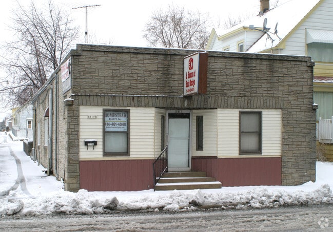
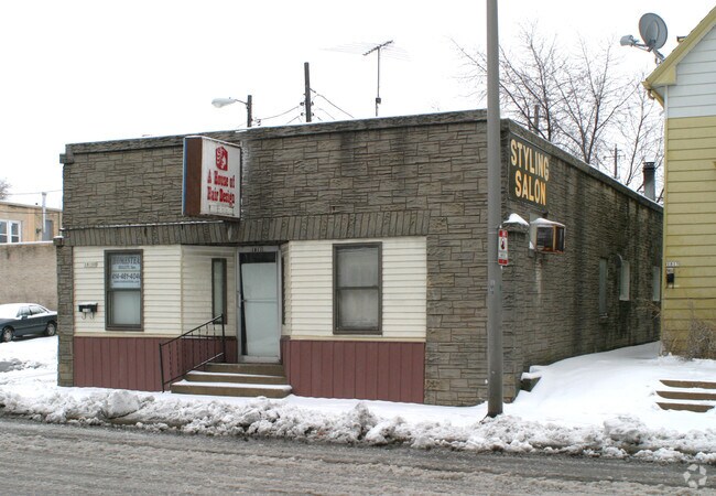
Property Record
1817 S 60Th St, Milwaukee, WI 53214
NEARBY LISTINGS FOR SALE OR LEASE
-
-
-
-
-
-
-
No Photo
-
View all Milwaukee listings for sale on LoopNet.com
Property Detail
1817 S 60Th St
Milwaukee-Waukesha-West Allis, WI
Cent Impr Co Subd
454-0620-000
CENT IMPR CO SUBD NO 2 LOT 36 BLK 7 EX PT FOR ALLEY
Commercialnec
Milwaukee
X
Wisconsin
55079C0088E
36
2024
0.10 AC
2024
West Allis
100100
Milwaukee/Madison
1,792 SF
DEMOGRAPHICS near 1817 S 60Th St
1 Mile
3 Mile
5 Mile
2024 Total Population
21,272
185,582
446,736
2029 Population
20,795
181,083
438,155
Pop Growth 2024-2029
(2.24%)
(2.42%)
(1.92%)
Average Age
39
37
37
2024 Total Households
9,436
76,740
187,023
HH Growth 2024-2029
(2.27%)
(2.44%)
(1.92%)
Median Household Inc
$55,774
$54,229
$55,612
Avg Household Size
2.20
2.30
2.30
2024 Avg HH Vehicles
2.00
2.00
1.00
Median Home Value
$162,822
$170,277
$190,927
Median Year Built
1949
1949
1951
Nearby Places
Map Layers
Map Styles
 Street
 Aerial
- Restaurants
- Banks
- Shops
- Fitness
- Groceries
PUBLIC TRANSPORTATION
COMMUTER RAIL
Milwaukee (Empire Builder - Amtrak)
DRIVE
WALK
Distance
Milwaukee (Empire Builder - Amtrak)
9 min
5.0 mi
General Mitchell Intl. Airport Amtrak Station (Hiawatha Service - Amtrak)
DRIVE
WALK
Distance
General Mitchell Intl. Airport Amtrak Station (Hiawatha Service - Amtrak)
19 min
8.5 mi
AIRPORT
General Mitchell International
DRIVE
WALK
Distance
General Mitchell International
19 min
8.7 mi
Freight Ports
Port Milwaukee
DRIVE
WALK
Distance
Port Milwaukee
12 min
4.7 mi
Nearby Properties
Address
Land Use
TOTAL SIZE
Lot Size
Zoning
Address
Land Use
TOTAL SIZE
Lot Size
Zoning
36.11 AC
Address
Land Use
TOTAL SIZE
Lot Size
Zoning
122.53 AC
TL
Address
Land Use
TOTAL SIZE
Lot Size
Zoning
1,709,128 SF
9.32 AC
PD
Address
Land Use
TOTAL SIZE
Lot Size
Zoning
5.12 AC
Address
Land Use
TOTAL SIZE
Lot Size
Zoning
Address
Land Use
TOTAL SIZE
Lot Size
Zoning
110,000 SF
7.59 AC
TL
Address
Land Use
TOTAL SIZE
Lot Size
Zoning
68.35 AC
TL
Address
Land Use
TOTAL SIZE
Lot Size
Zoning
11.38 AC
TL
Address
Land Use
TOTAL SIZE
Lot Size
Zoning
8,881 SF
7.52 AC
Address
Land Use
TOTAL SIZE
Lot Size
Zoning
13.39 AC
Address
Land Use
TOTAL SIZE
Lot Size
Zoning
9.33 AC
PUD
Address
Land Use
TOTAL SIZE
Lot Size
Zoning
47.96 AC
TL
Address
Land Use
TOTAL SIZE
Lot Size
Zoning
3.74 AC
PUD
Address
Land Use
TOTAL SIZE
Lot Size
Zoning
Address
Land Use
TOTAL SIZE
Lot Size
Zoning
39.81 AC
Address
Land Use
TOTAL SIZE
Lot Size
Zoning
8.78 AC
Address
Land Use
TOTAL SIZE
Lot Size
Zoning
0.36 AC
Address
Land Use
TOTAL SIZE
Lot Size
Zoning
20.61 AC
TL
Address
Land Use
TOTAL SIZE
Lot Size
Zoning
132,289 SF
5.34 AC
PD
Address
Land Use
TOTAL SIZE
Lot Size
Zoning
Address
Land Use
TOTAL SIZE
Lot Size
Zoning
12.47 AC
Address
Land Use
TOTAL SIZE
Lot Size
Zoning
35.55 AC
INSTITUTIO
Address
Land Use
TOTAL SIZE
Lot Size
Zoning
174,510 SF
7.37 AC
PD
Address
Land Use
TOTAL SIZE
Lot Size
Zoning
20.49 AC
TL
Address
Land Use
TOTAL SIZE
Lot Size
Zoning
4.63 AC
IO2
Address
Land Use
TOTAL SIZE
Lot Size
Zoning
164,825 SF
7.93 AC
PD
Address
Land Use
TOTAL SIZE
Lot Size
Zoning
159,673 SF
6.69 AC
PD
Address
Land Use
TOTAL SIZE
Lot Size
Zoning
205,632 SF
18 AC
PD
Address
Land Use
TOTAL SIZE
Lot Size
Zoning
113,300 SF
5.60 AC
IL1
Address
Land Use
TOTAL SIZE
Lot Size
Zoning
156,753 SF
12.28 AC
LB1
The World's #1 Commercial Real Estate Marketplace
Connect with us
© 2025 CoStar Group
The information above has been obtained from sources believed reliable. While we do not doubt its accuracy we have not verified it and make no guarantee, warranty or representation about it. It is your responsibility to independently confirm its accuracy and completeness. Any projections, opinions, assumptions, or estimates used are for example only and do not represent the current or future performance of the property. The value of this transaction to you depends on tax and other factors which should be evaluated by your tax, financial, and legal advisors. You and your advisors should conduct a careful, independent investigation of the property to determine to your satisfaction the suitability of the property for your needs.