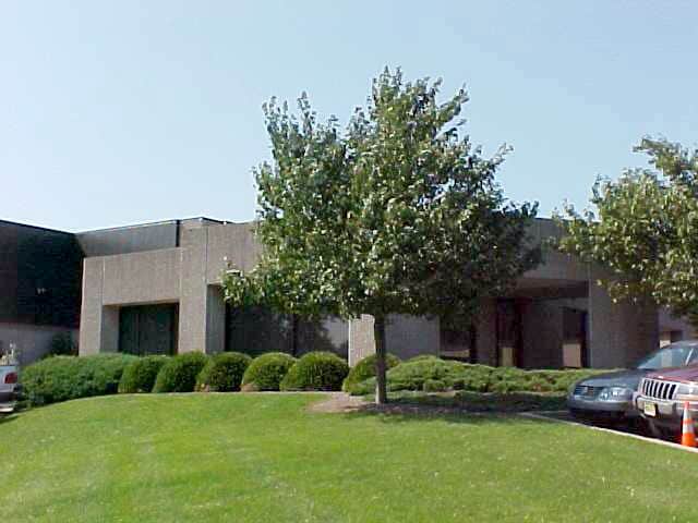
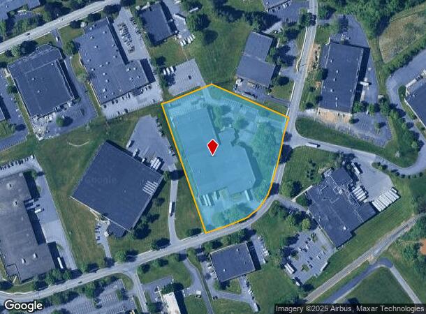
Property Record
1817 William Penn Way, Lancaster, PA 17601
NEARBY LISTINGS FOR SALE OR LEASE
Property Detail
1817 William Penn Way
Lancaster, PA
Alta Acsm Land Title Surv
310-98047-0-0000
1817 WILLIAM PENN WAY
Lightindustrial
Lancaster
X
Pennsylvania
42071C0386F
4
2024
4.90 AC
2025
Lancaster County
013203
Philadelphia
77,489 SF
DEMOGRAPHICS near 1817 William Penn Way
1 Mile
3 Mile
5 Mile
2024 Total Population
4,620
53,524
143,750
2029 Population
4,633
53,861
144,636
Pop Growth 2024-2029
+ 0.28%
+ 0.63%
+ 0.62%
Average Age
43
40
40
2024 Total Households
2,065
19,707
54,861
HH Growth 2024-2029
+ 0.34%
+ 0.57%
+ 0.56%
Median Household Inc
$72,170
$73,468
$70,675
Avg Household Size
2.20
2.60
2.40
2024 Avg HH Vehicles
2.00
2.00
2.00
Median Home Value
$251,948
$248,031
$241,175
Median Year Built
1988
1969
1963
Nearby Places
Map Layers
Map Styles
 Street
 Aerial
- Restaurants
- Banks
- Shops
- Fitness
- Groceries
PUBLIC TRANSPORTATION
COMMUTER RAIL
DRIVE
WALK
Distance
11 min
5.4 mi
AIRPORT
Harrisburg International
DRIVE
WALK
Distance
Harrisburg International
46 min
34.8 mi
Freight Ports
Port Newark Container Terminal
DRIVE
WALK
Distance
Port Newark Container Terminal
78 min
46.6 mi
Nearby Properties
Address
Land Use
TOTAL SIZE
Lot Size
Zoning
Address
Land Use
TOTAL SIZE
Lot Size
Zoning
1,120,221 SF
8.40 AC
Address
Land Use
TOTAL SIZE
Lot Size
Zoning
871,695 SF
69.40 AC
R2
Address
Land Use
TOTAL SIZE
Lot Size
Zoning
315,373 SF
4.73 AC
DF
Address
Land Use
TOTAL SIZE
Lot Size
Zoning
403,771 SF
106.93 AC
Address
Land Use
TOTAL SIZE
Lot Size
Zoning
610,108 SF
39.96 AC
C-2
Address
Land Use
TOTAL SIZE
Lot Size
Zoning
419,136 SF
34.11 AC
Address
Land Use
TOTAL SIZE
Lot Size
Zoning
333,301 SF
24.15 AC
MU
Address
Land Use
TOTAL SIZE
Lot Size
Zoning
275,959 SF
68.50 AC
IN
Address
Land Use
TOTAL SIZE
Lot Size
Zoning
322,380 SF
33.29 AC
R-3
Address
Land Use
TOTAL SIZE
Lot Size
Zoning
234,386 SF
15.30 AC
MU
Address
Land Use
TOTAL SIZE
Lot Size
Zoning
289,398 SF
35.20 AC
C-2
Address
Land Use
TOTAL SIZE
Lot Size
Zoning
254,079 SF
21.54 AC
Address
Land Use
TOTAL SIZE
Lot Size
Zoning
21.41 AC
Address
Land Use
TOTAL SIZE
Lot Size
Zoning
234,681 SF
7.50 AC
MU
Address
Land Use
TOTAL SIZE
Lot Size
Zoning
323,300 SF
21.60 AC
C-2
Address
Land Use
TOTAL SIZE
Lot Size
Zoning
125,073 SF
19.07 AC
I
Address
Land Use
TOTAL SIZE
Lot Size
Zoning
302,460 SF
51.80 AC
R4
Address
Land Use
TOTAL SIZE
Lot Size
Zoning
87,502 SF
11.69 AC
MU
Address
Land Use
TOTAL SIZE
Lot Size
Zoning
125,153 SF
24.10 AC
Address
Land Use
TOTAL SIZE
Lot Size
Zoning
123,445 SF
13.66 AC
I
Address
Land Use
TOTAL SIZE
Lot Size
Zoning
198,492 SF
24.74 AC
R-2
Address
Land Use
TOTAL SIZE
Lot Size
Zoning
844,700 SF
59.50 AC
I
Address
Land Use
TOTAL SIZE
Lot Size
Zoning
63,514 SF
177.90 AC
R-1
Address
Land Use
TOTAL SIZE
Lot Size
Zoning
1,137,774 SF
54.21 AC
SM
Address
Land Use
TOTAL SIZE
Lot Size
Zoning
136,104 SF
11.14 AC
Address
Land Use
TOTAL SIZE
Lot Size
Zoning
244,922 SF
18.40 AC
MU
Address
Land Use
TOTAL SIZE
Lot Size
Zoning
251,051 SF
31.10 AC
R-3
Address
Land Use
TOTAL SIZE
Lot Size
Zoning
1,042,820 SF
74.80 AC
CM
Address
Land Use
TOTAL SIZE
Lot Size
Zoning
137,933 SF
16.11 AC
Address
Land Use
TOTAL SIZE
Lot Size
Zoning
111,896 SF
8.30 AC
The World's #1 Commercial Real Estate Marketplace
Connect with us
© 2025 CoStar Group
The information above has been obtained from sources believed reliable. While we do not doubt its accuracy we have not verified it and make no guarantee, warranty or representation about it. It is your responsibility to independently confirm its accuracy and completeness. Any projections, opinions, assumptions, or estimates used are for example only and do not represent the current or future performance of the property. The value of this transaction to you depends on tax and other factors which should be evaluated by your tax, financial, and legal advisors. You and your advisors should conduct a careful, independent investigation of the property to determine to your satisfaction the suitability of the property for your needs.