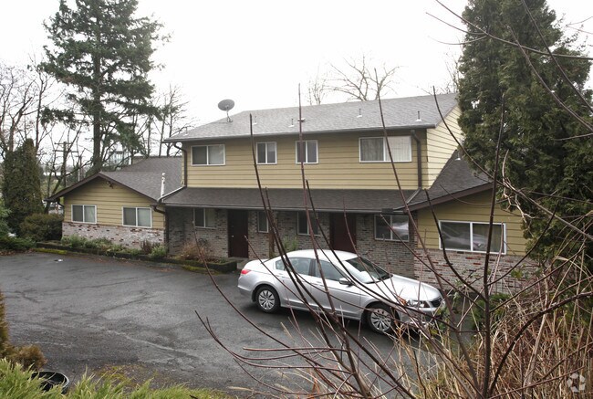
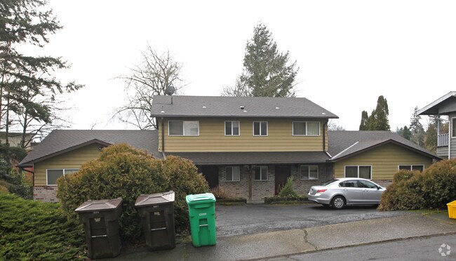
Property Record
1818 Sw Carolina St, Portland, OR 97239

NEARBY LISTINGS FOR SALE OR LEASE
Property Detail
1818 Sw Carolina St
Portland-Vancouver-Hillsboro, OR-WA
Bertha
R115821
BERTHA, BLOCK 12, LOT 1&2 EXC PT IN HWY
Quadruplex
Multnomah
ARE
Oregon
41067C0575E
1,2
2025
0.22 AC
2025
Hillsdale
006100
Portland
4,288 SF
DEMOGRAPHICS near 1818 Sw Carolina St
1 Mile
3 Mile
5 Mile
2024 Total Population
14,674
123,731
385,344
2029 Population
14,320
122,619
384,522
Pop Growth 2024-2029
(2.41%)
(0.90%)
(0.21%)
Average Age
41
41
41
2024 Total Households
6,394
58,461
182,729
HH Growth 2024-2029
(2.67%)
(0.87%)
(0.28%)
Median Household Inc
$98,207
$93,335
$87,837
Avg Household Size
2.30
2.00
2.00
2024 Avg HH Vehicles
2.00
1.00
1.00
Median Home Value
$703,634
$701,539
$675,756
Median Year Built
1968
1975
1972
Nearby Places
Map Layers
Map Styles
 Street
 Aerial
- Restaurants
- Banks
- Shops
- Fitness
- Groceries
PUBLIC TRANSPORTATION
COMMUTER RAIL
DRIVE
WALK
Distance
13 min
5.1 mi
Beaverton Transit Center (West Side Express) (Westside Express Service - Tri-County Metropolitan Transportation District of Oregon Rail (TriMet Rail))
DRIVE
WALK
Distance
Beaverton Transit Center (West Side Express) (Westside Express Service - Tri-County Metropolitan Transportation District of Oregon Rail (TriMet Rail))
14 min
5.5 mi
AIRPORT
Portland International
DRIVE
WALK
Distance
Portland International
28 min
16.6 mi
Nearby Properties
Address
Land Use
TOTAL SIZE
Lot Size
Zoning
Address
Land Use
TOTAL SIZE
Lot Size
Zoning
27.58 AC
EX
Address
Land Use
TOTAL SIZE
Lot Size
Zoning
931,749 SF
85.50 AC
CI1
Address
Land Use
TOTAL SIZE
Lot Size
Zoning
57,314 SF
60.69 AC
OS
Address
Land Use
TOTAL SIZE
Lot Size
Zoning
560,000 SF
0.15 AC
CX
Address
Land Use
TOTAL SIZE
Lot Size
Zoning
20.71 AC
OS
Address
Land Use
TOTAL SIZE
Lot Size
Zoning
409,260 SF
7.41 AC
EX
Address
Land Use
TOTAL SIZE
Lot Size
Zoning
1.09 AC
EX
Address
Land Use
TOTAL SIZE
Lot Size
Zoning
2.24 AC
CX
Address
Land Use
TOTAL SIZE
Lot Size
Zoning
304,836 SF
10.85 AC
CX
Address
Land Use
TOTAL SIZE
Lot Size
Zoning
598,328 SF
12.32 AC
CX
Address
Land Use
TOTAL SIZE
Lot Size
Zoning
460,000 SF
0.92 AC
CX
Address
Land Use
TOTAL SIZE
Lot Size
Zoning
689,840 SF
0.92 AC
CX
Address
Land Use
TOTAL SIZE
Lot Size
Zoning
125,217 SF
0.23 AC
CX
Address
Land Use
TOTAL SIZE
Lot Size
Zoning
97,465 SF
107.18 AC
OS
Address
Land Use
TOTAL SIZE
Lot Size
Zoning
584,483 SF
0.90 AC
CX
Address
Land Use
TOTAL SIZE
Lot Size
Zoning
306,000 SF
1.21 AC
NULL
Address
Land Use
TOTAL SIZE
Lot Size
Zoning
251,293 SF
14.15 AC
IR
Address
Land Use
TOTAL SIZE
Lot Size
Zoning
596,161 SF
0.92 AC
CX
Address
Land Use
TOTAL SIZE
Lot Size
Zoning
175,880 SF
36.43 AC
OS
Address
Land Use
TOTAL SIZE
Lot Size
Zoning
387,000 SF
0.88 AC
CXD
Address
Land Use
TOTAL SIZE
Lot Size
Zoning
138,295 SF
29.79 AC
CI1
Address
Land Use
TOTAL SIZE
Lot Size
Zoning
473,746 SF
1.68 AC
Address
Land Use
TOTAL SIZE
Lot Size
Zoning
291,451 SF
1.64 AC
RH
Address
Land Use
TOTAL SIZE
Lot Size
Zoning
262,645 SF
1 AC
CX
Address
Land Use
TOTAL SIZE
Lot Size
Zoning
477,636 SF
0.90 AC
CXD
Address
Land Use
TOTAL SIZE
Lot Size
Zoning
191,724 SF
0.45 AC
CXD
Address
Land Use
TOTAL SIZE
Lot Size
Zoning
388,191 SF
1.86 AC
CX
Address
Land Use
TOTAL SIZE
Lot Size
Zoning
79,646 SF
9.23 AC
R2R7
Address
Land Use
TOTAL SIZE
Lot Size
Zoning
42,920 SF
1.16 AC
CX
Address
Land Use
TOTAL SIZE
Lot Size
Zoning
147,334 SF
10.92 AC
IG1
The World's #1 Commercial Real Estate Marketplace
Connect with us
© 2026 CoStar Group
The information above has been obtained from sources believed reliable. While we do not doubt its accuracy we have not verified it and make no guarantee, warranty or representation about it. It is your responsibility to independently confirm its accuracy and completeness. Any projections, opinions, assumptions, or estimates used are for example only and do not represent the current or future performance of the property. The value of this transaction to you depends on tax and other factors which should be evaluated by your tax, financial, and legal advisors. You and your advisors should conduct a careful, independent investigation of the property to determine to your satisfaction the suitability of the property for your needs.