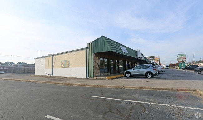
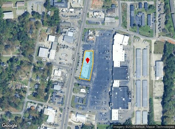
Property Record
1819 Center Point Pky, Birmingham, AL 35215
NEARBY LISTINGS FOR SALE OR LEASE
Property Detail
1819 Center Point Pky
12-00-19-2-001-006.000
BEG 256 FT SW OF THE SE INTER OF POLLY REED RD & CENTER POINT RD TH SWLY 310 FT ALG CENTER POINT RD TH SELY 119 FT TH NELY 190 FT TH NLY 149 FT TH W 95 FT TO POB SEC 19 TP 16S R1W
Lumberyard
Jefferson
X
Alabama
01073C0243J
0.89 AC
2023
Center Point
2024
Birmingham
005908
Birmingham-Hoover, AL
19,786 SF
DEMOGRAPHICS near 1819 Center Point Pky
1 Mile
3 Mile
5 Mile
2024 Total Population
9,834
55,801
91,433
2029 Population
9,763
54,663
89,489
Pop Growth 2024-2029
(0.72%)
(2.04%)
(2.13%)
Average Age
36
37
38
2024 Total Households
3,713
20,894
34,837
HH Growth 2024-2029
(0.75%)
(2.09%)
(2.18%)
Median Household Inc
$36,896
$47,607
$52,334
Avg Household Size
2.50
2.60
2.50
2024 Avg HH Vehicles
2.00
2.00
2.00
Median Home Value
$117,211
$142,254
$157,016
Median Year Built
1972
1975
1976
Nearby Places
Map Layers
Map Styles
 Street
 Aerial
- Restaurants
- Banks
- Shops
- Fitness
- Groceries
PUBLIC TRANSPORTATION
AIRPORT
Birmingham-Shuttlesworth International
DRIVE
WALK
Distance
Birmingham-Shuttlesworth International
15 min
8.8 mi
Freight Ports
Port of Mobile
DRIVE
WALK
Distance
Port of Mobile
297 min
269.6 mi
SALE & LEASE HISTORY
LISTING DATE
SALE/LEASE

Sep 25, 2016
For Lease
Nearby Properties
Address
Land Use
TOTAL SIZE
Lot Size
Zoning
Address
Land Use
TOTAL SIZE
Lot Size
Zoning
152,664 SF
12.44 AC
CO&I
Address
Land Use
TOTAL SIZE
Lot Size
Zoning
128,233 SF
CO&I
Address
Land Use
TOTAL SIZE
Lot Size
Zoning
150,160 SF
12 AC
INST
Address
Land Use
TOTAL SIZE
Lot Size
Zoning
1 SF
7.08 AC
CB2
Address
Land Use
TOTAL SIZE
Lot Size
Zoning
58,509 SF
CO&I
Address
Land Use
TOTAL SIZE
Lot Size
Zoning
207,383 SF
17 AC
CR5
Address
Land Use
TOTAL SIZE
Lot Size
Zoning
39,890 SF
7.10 AC
R8
Address
Land Use
TOTAL SIZE
Lot Size
Zoning
57,296 SF
CO&I
Address
Land Use
TOTAL SIZE
Lot Size
Zoning
623,200 SF
50 AC
CM2
Address
Land Use
TOTAL SIZE
Lot Size
Zoning
218,922 SF
21 AC
CR5
Address
Land Use
TOTAL SIZE
Lot Size
Zoning
112,806 SF
2.04 AC
R2
Address
Land Use
TOTAL SIZE
Lot Size
Zoning
192,596 SF
13.79 AC
CR5
Address
Land Use
TOTAL SIZE
Lot Size
Zoning
147,200 SF
7.93 AC
CR5
Address
Land Use
TOTAL SIZE
Lot Size
Zoning
531,808 SF
23.96 AC
I4&A
Address
Land Use
TOTAL SIZE
Lot Size
Zoning
502,302 SF
24.61 AC
I4&A
Address
Land Use
TOTAL SIZE
Lot Size
Zoning
115,490 SF
3.88 AC
R2
Address
Land Use
TOTAL SIZE
Lot Size
Zoning
95,172 SF
6.40 AC
R2
Address
Land Use
TOTAL SIZE
Lot Size
Zoning
125,252 SF
8.07 AC
R4
Address
Land Use
TOTAL SIZE
Lot Size
Zoning
116,732 SF
4.06 AC
R-4
Address
Land Use
TOTAL SIZE
Lot Size
Zoning
179,464 SF
17.70 AC
M3
Address
Land Use
TOTAL SIZE
Lot Size
Zoning
86,434 SF
8.20 AC
QM1
Address
Land Use
TOTAL SIZE
Lot Size
Zoning
72,506 SF
4 AC
R2
Address
Land Use
TOTAL SIZE
Lot Size
Zoning
80,834 SF
7.13 AC
CR5
Address
Land Use
TOTAL SIZE
Lot Size
Zoning
43,451 SF
5.22 AC
INST
Address
Land Use
TOTAL SIZE
Lot Size
Zoning
340,000 SF
29 AC
I4
Address
Land Use
TOTAL SIZE
Lot Size
Zoning
26,169 SF
71 AC
R2
Address
Land Use
TOTAL SIZE
Lot Size
Zoning
109,878 SF
10 AC
C1
Address
Land Use
TOTAL SIZE
Lot Size
Zoning
115,544 SF
12 AC
CB2
Address
Land Use
TOTAL SIZE
Lot Size
Zoning
74,159 SF
2.50 AC
INST
Address
Land Use
TOTAL SIZE
Lot Size
Zoning
43,298 SF
5.59 AC
INST
The World's #1 Commercial Real Estate Marketplace
Connect with us
© 2025 CoStar Group
The information above has been obtained from sources believed reliable. While we do not doubt its accuracy we have not verified it and make no guarantee, warranty or representation about it. It is your responsibility to independently confirm its accuracy and completeness. Any projections, opinions, assumptions, or estimates used are for example only and do not represent the current or future performance of the property. The value of this transaction to you depends on tax and other factors which should be evaluated by your tax, financial, and legal advisors. You and your advisors should conduct a careful, independent investigation of the property to determine to your satisfaction the suitability of the property for your needs.