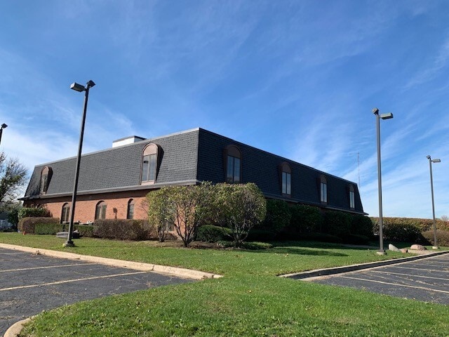
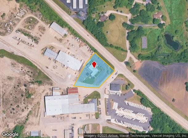
Property Record
1819 Dot St, Mchenry, IL 60050
NEARBY LISTINGS FOR SALE OR LEASE
-
-
View all Mchenry listings for sale on LoopNet.com
Property Detail
1819 Dot St
Chicago
Mchenry Plat 13
Chicago-Naperville-Elgin, IL-IN
DOC 2023R0003269 NE PC LT 3 LYING W OF DOT ST MCHENRY PLAT 13
09-28-102-025
McHenry
Commercialnec
Illinois
2024
3
2024
1.61 AC
870501
Far Northwest
11,982 SF
DEMOGRAPHICS near 1819 Dot St
1 Mile
3 Mile
5 Mile
2024 Total Population
3,201
31,572
57,067
2029 Population
3,216
31,745
57,494
Pop Growth 2024-2029
+ 0.47%
+ 0.55%
+ 0.75%
Average Age
40
41
42
2024 Total Households
1,213
12,287
22,030
HH Growth 2024-2029
+ 0.49%
+ 0.55%
+ 0.75%
Median Household Inc
$72,128
$78,405
$84,334
Avg Household Size
2.60
2.50
2.50
2024 Avg HH Vehicles
2.00
2.00
2.00
Median Home Value
$172,849
$198,878
$229,192
Median Year Built
1975
1982
1984
Nearby Places
Map Layers
Map Styles
 Street
 Aerial
- Restaurants
- Banks
- Shops
- Fitness
- Groceries
PUBLIC TRANSPORTATION
COMMUTER RAIL
McHenry Station (Union Pacific Northwest Line - Northeast Illinois Regional Commuter Railroad (Metra))
DRIVE
WALK
Distance
McHenry Station (Union Pacific Northwest Line - Northeast Illinois Regional Commuter Railroad (Metra))
6 min
2.2 mi
Woodstock Station (Union Pacific Northwest Line - Northeast Illinois Regional Commuter Railroad (Metra))
DRIVE
WALK
Distance
Woodstock Station (Union Pacific Northwest Line - Northeast Illinois Regional Commuter Railroad (Metra))
14 min
8.8 mi
AIRPORT
Chicago O'Hare International
DRIVE
WALK
Distance
Chicago O'Hare International
64 min
43.7 mi
SALE & LEASE HISTORY
LISTING DATE
SALE/LEASE

Sep 25, 2016
For Lease
Sep 23, 2016
For Sale
Nov 08, 2021
For Lease
Feb 17, 2022
For Sale
Nearby Properties
Address
Land Use
TOTAL SIZE
Lot Size
Zoning
Address
Land Use
TOTAL SIZE
Lot Size
Zoning
20.51 AC
Address
Land Use
TOTAL SIZE
Lot Size
Zoning
5,000 SF
30.62 AC
Address
Land Use
TOTAL SIZE
Lot Size
Zoning
10.75 AC
Address
Land Use
TOTAL SIZE
Lot Size
Zoning
54,986 SF
5.83 AC
Address
Land Use
TOTAL SIZE
Lot Size
Zoning
47,440 SF
3.59 AC
Address
Land Use
TOTAL SIZE
Lot Size
Zoning
191,960 SF
19 AC
Address
Land Use
TOTAL SIZE
Lot Size
Zoning
185,809 SF
21 AC
Address
Land Use
TOTAL SIZE
Lot Size
Zoning
10,082 SF
0.80 AC
Address
Land Use
TOTAL SIZE
Lot Size
Zoning
0.50 AC
Address
Land Use
TOTAL SIZE
Lot Size
Zoning
21,686 SF
0.90 AC
Address
Land Use
TOTAL SIZE
Lot Size
Zoning
267,134 SF
5.59 AC
Address
Land Use
TOTAL SIZE
Lot Size
Zoning
81,264 SF
0.50 AC
Address
Land Use
TOTAL SIZE
Lot Size
Zoning
3.11 AC
Address
Land Use
TOTAL SIZE
Lot Size
Zoning
115,923 SF
12 AC
Address
Land Use
TOTAL SIZE
Lot Size
Zoning
83,570 SF
3 AC
Address
Land Use
TOTAL SIZE
Lot Size
Zoning
83,744 SF
8.06 AC
Address
Land Use
TOTAL SIZE
Lot Size
Zoning
66,380 SF
5.36 AC
Address
Land Use
TOTAL SIZE
Lot Size
Zoning
64,614 SF
5 AC
Address
Land Use
TOTAL SIZE
Lot Size
Zoning
57,000 SF
0.86 AC
Address
Land Use
TOTAL SIZE
Lot Size
Zoning
94,900 SF
3.84 AC
Address
Land Use
TOTAL SIZE
Lot Size
Zoning
Address
Land Use
TOTAL SIZE
Lot Size
Zoning
1,704 SF
0.25 AC
Address
Land Use
TOTAL SIZE
Lot Size
Zoning
10,432 SF
3 AC
Address
Land Use
TOTAL SIZE
Lot Size
Zoning
2,250 SF
6.59 AC
Address
Land Use
TOTAL SIZE
Lot Size
Zoning
103,822 SF
7.64 AC
Address
Land Use
TOTAL SIZE
Lot Size
Zoning
38,783 SF
10.92 AC
Address
Land Use
TOTAL SIZE
Lot Size
Zoning
68,604 SF
4.59 AC
Address
Land Use
TOTAL SIZE
Lot Size
Zoning
70,136 SF
3.15 AC
Address
Land Use
TOTAL SIZE
Lot Size
Zoning
75,402 SF
7.34 AC
Address
Land Use
TOTAL SIZE
Lot Size
Zoning
164,700 SF
13.89 AC
The World's #1 Commercial Real Estate Marketplace
Connect with us
© 2026 CoStar Group
The information above has been obtained from sources believed reliable. While we do not doubt its accuracy we have not verified it and make no guarantee, warranty or representation about it. It is your responsibility to independently confirm its accuracy and completeness. Any projections, opinions, assumptions, or estimates used are for example only and do not represent the current or future performance of the property. The value of this transaction to you depends on tax and other factors which should be evaluated by your tax, financial, and legal advisors. You and your advisors should conduct a careful, independent investigation of the property to determine to your satisfaction the suitability of the property for your needs.