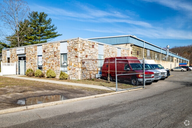
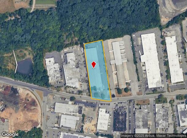
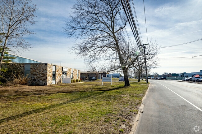
Property Record
182 Bethpage Sweet Hollow Rd, Old Bethpage, NY 11804
NEARBY LISTINGS FOR SALE OR LEASE
Property Detail
182 Bethpage Sweet Hollow Rd
2489-47-A-00-0275-0
TOWN #3 SCH DIST 020
Skatingrink
Nassau
X
New York
36103C0615H
275
2025
2.35 AC
2025
Eastern Nassau
520100
Long Island (New York)
48,480 SF
Nassau County-Suffolk County, NY
DEMOGRAPHICS near 182 Bethpage Sweet Hollow Rd
1 Mile
3 Mile
5 Mile
2024 Total Population
4,236
75,412
299,532
2029 Population
4,200
74,245
294,021
Pop Growth 2024-2029
(0.85%)
(1.55%)
(1.84%)
Average Age
46
44
42
2024 Total Households
1,590
26,660
96,822
HH Growth 2024-2029
(0.94%)
(1.64%)
(1.94%)
Median Household Inc
$161,120
$136,709
$130,113
Avg Household Size
2.60
2.70
3.00
2024 Avg HH Vehicles
2.00
2.00
2.00
Median Home Value
$745,790
$674,652
$624,971
Median Year Built
1965
1958
1957
Nearby Places
Map Layers
Map Styles
 Street
 Aerial
- Restaurants
- Banks
- Shops
- Fitness
- Groceries
PUBLIC TRANSPORTATION
COMMUTER RAIL
Farmingdale Station (Ronkonkoma Branch - Long Island Rail Road)
DRIVE
WALK
Distance
Farmingdale Station (Ronkonkoma Branch - Long Island Rail Road)
9 min
2.7 mi
Bethpage Station (Ronkonkoma Branch - Long Island Rail Road)
DRIVE
WALK
Distance
Bethpage Station (Ronkonkoma Branch - Long Island Rail Road)
10 min
3.9 mi
AIRPORT
Long Island MacArthur
DRIVE
WALK
Distance
Long Island MacArthur
31 min
20.1 mi
John F Kennedy International
DRIVE
WALK
Distance
John F Kennedy International
37 min
25.8 mi
LaGuardia
DRIVE
WALK
Distance
LaGuardia
38 min
28.6 mi
Nearby Properties
Address
Land Use
TOTAL SIZE
Lot Size
Zoning
Address
Land Use
TOTAL SIZE
Lot Size
Zoning
37 AC
I2
Address
Land Use
TOTAL SIZE
Lot Size
Zoning
116,514 SF
382 AC
Address
Land Use
TOTAL SIZE
Lot Size
Zoning
35,978 SF
375.68 AC
Address
Land Use
TOTAL SIZE
Lot Size
Zoning
16,520 SF
160.33 AC
Address
Land Use
TOTAL SIZE
Lot Size
Zoning
1,945 SF
278.09 AC
Address
Land Use
TOTAL SIZE
Lot Size
Zoning
1,003,826 SF
84.27 AC
Address
Land Use
TOTAL SIZE
Lot Size
Zoning
33.80 AC
Address
Land Use
TOTAL SIZE
Lot Size
Zoning
647,177 SF
51.88 AC
Address
Land Use
TOTAL SIZE
Lot Size
Zoning
77,270 SF
21.67 AC
Address
Land Use
TOTAL SIZE
Lot Size
Zoning
336,442 SF
43.50 AC
G
Address
Land Use
TOTAL SIZE
Lot Size
Zoning
15,825 SF
22.94 AC
Address
Land Use
TOTAL SIZE
Lot Size
Zoning
288 SF
194.85 AC
Address
Land Use
TOTAL SIZE
Lot Size
Zoning
659,098 SF
34.76 AC
Address
Land Use
TOTAL SIZE
Lot Size
Zoning
3,951 SF
44.33 AC
Address
Land Use
TOTAL SIZE
Lot Size
Zoning
52.10 AC
Address
Land Use
TOTAL SIZE
Lot Size
Zoning
52,750 SF
55.67 AC
Address
Land Use
TOTAL SIZE
Lot Size
Zoning
37.20 AC
I2
Address
Land Use
TOTAL SIZE
Lot Size
Zoning
24.75 AC
R40
Address
Land Use
TOTAL SIZE
Lot Size
Zoning
332,290 SF
25.91 AC
Address
Land Use
TOTAL SIZE
Lot Size
Zoning
183.15 AC
Address
Land Use
TOTAL SIZE
Lot Size
Zoning
11.50 AC
C10
Address
Land Use
TOTAL SIZE
Lot Size
Zoning
177,845 SF
22.04 AC
Address
Land Use
TOTAL SIZE
Lot Size
Zoning
2.92 AC
R20
Address
Land Use
TOTAL SIZE
Lot Size
Zoning
34,500 SF
16 AC
Address
Land Use
TOTAL SIZE
Lot Size
Zoning
84,714 SF
15.09 AC
Address
Land Use
TOTAL SIZE
Lot Size
Zoning
12 AC
I1
Address
Land Use
TOTAL SIZE
Lot Size
Zoning
22.20 AC
I1
Address
Land Use
TOTAL SIZE
Lot Size
Zoning
14.40 AC
I1
Address
Land Use
TOTAL SIZE
Lot Size
Zoning
228,527 SF
4.81 AC
Address
Land Use
TOTAL SIZE
Lot Size
Zoning
74.90 AC
G
The World's #1 Commercial Real Estate Marketplace
Connect with us
© 2025 CoStar Group
The information above has been obtained from sources believed reliable. While we do not doubt its accuracy we have not verified it and make no guarantee, warranty or representation about it. It is your responsibility to independently confirm its accuracy and completeness. Any projections, opinions, assumptions, or estimates used are for example only and do not represent the current or future performance of the property. The value of this transaction to you depends on tax and other factors which should be evaluated by your tax, financial, and legal advisors. You and your advisors should conduct a careful, independent investigation of the property to determine to your satisfaction the suitability of the property for your needs.