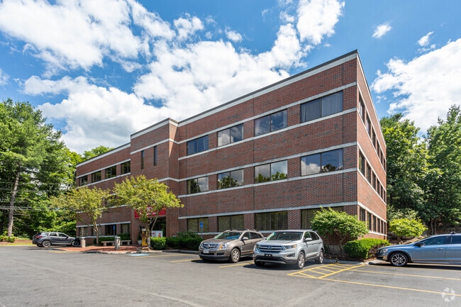
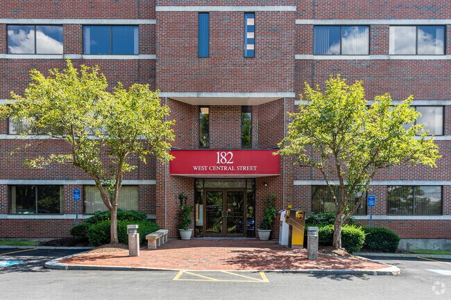
Property Record
182 E Central St, Natick, MA 01760
Current Lease Availabilities
NEARBY LISTINGS FOR SALE OR LEASE
Property Detail
182 E Central St
Condominium
Middlesex
X
Massachusetts
25021C0012F
0.42 AC
2025
Framingham/Natick
2025
Boston
382601
Boston-Cambridge-Newton, MA-NH
1,828 SF
NATI-000037-000000-000104A
DEMOGRAPHICS near 182 E Central St
1 Mile
3 Mile
5 Mile
2024 Total Population
11,240
77,586
155,829
2029 Population
11,125
76,847
154,654
Pop Growth 2024-2029
(1.02%)
(0.95%)
(0.75%)
Average Age
39
40
41
2024 Total Households
4,730
30,098
58,496
HH Growth 2024-2029
(1.35%)
(1.10%)
(0.84%)
Median Household Inc
$94,385
$95,515
$116,148
Avg Household Size
2.30
2.50
2.50
2024 Avg HH Vehicles
1.00
2.00
2.00
Median Home Value
$597,850
$638,947
$683,762
Median Year Built
1979
1961
1965
Nearby Places
Map Layers
Map Styles
 Street
 Aerial
- Restaurants
- Banks
- Shops
- Fitness
- Groceries
PUBLIC TRANSPORTATION
COMMUTER RAIL
Natick (Framingham/Worcester Line - Massachusetts Bay Transportation Authority Commuter Rail (Purple Line))
DRIVE
WALK
Distance
Natick (Framingham/Worcester Line - Massachusetts Bay Transportation Authority Commuter Rail (Purple Line))
2 min
1.1 mi
Wellesley Square (Framingham/Worcester Line - Massachusetts Bay Transportation Authority Commuter Rail (Purple Line))
DRIVE
WALK
Distance
Wellesley Square (Framingham/Worcester Line - Massachusetts Bay Transportation Authority Commuter Rail (Purple Line))
4 min
2.1 mi
AIRPORT
General Edward Lawrence Logan International
DRIVE
WALK
Distance
General Edward Lawrence Logan International
32 min
19.8 mi
Worcester Regional
DRIVE
WALK
Distance
Worcester Regional
52 min
30.7 mi
Freight Ports
Port of Boston
DRIVE
WALK
Distance
Port of Boston
31 min
18.1 mi
Nearby Properties
Address
Land Use
TOTAL SIZE
Lot Size
Zoning
Address
Land Use
TOTAL SIZE
Lot Size
Zoning
246,505 SF
6.48 AC
INII
Address
Land Use
TOTAL SIZE
Lot Size
Zoning
509,007 SF
22.27 AC
HM-I
Address
Land Use
TOTAL SIZE
Lot Size
Zoning
304,444 SF
16.88 AC
INII
Address
Land Use
TOTAL SIZE
Lot Size
Zoning
10.87 AC
SRD 10
Address
Land Use
TOTAL SIZE
Lot Size
Zoning
94,545 SF
11.70 AC
RSA
Address
Land Use
TOTAL SIZE
Lot Size
Zoning
188,746 SF
46.90 AC
RSA
Address
Land Use
TOTAL SIZE
Lot Size
Zoning
15,974 SF
2.45 AC
ED
Address
Land Use
TOTAL SIZE
Lot Size
Zoning
6.33 AC
SR10
Address
Land Use
TOTAL SIZE
Lot Size
Zoning
269,426 SF
HM-II
Address
Land Use
TOTAL SIZE
Lot Size
Zoning
165,382 SF
12.46 AC
HPU
Address
Land Use
TOTAL SIZE
Lot Size
Zoning
15.08 AC
SR10
Address
Land Use
TOTAL SIZE
Lot Size
Zoning
1,683 SF
46.10 AC
SR15
Address
Land Use
TOTAL SIZE
Lot Size
Zoning
122,748 SF
16.90 AC
HPU
Address
Land Use
TOTAL SIZE
Lot Size
Zoning
79.30 AC
RSA
Address
Land Use
TOTAL SIZE
Lot Size
Zoning
3.80 AC
Address
Land Use
TOTAL SIZE
Lot Size
Zoning
25.70 AC
SR10
Address
Land Use
TOTAL SIZE
Lot Size
Zoning
80.85 AC
SR40
Address
Land Use
TOTAL SIZE
Lot Size
Zoning
13,244 SF
12.72 AC
SR10
Address
Land Use
TOTAL SIZE
Lot Size
Zoning
75,625 SF
23.23 AC
B
Address
Land Use
TOTAL SIZE
Lot Size
Zoning
198,692 SF
2.60 AC
CII
Address
Land Use
TOTAL SIZE
Lot Size
Zoning
199,320 SF
16.65 AC
RSA
Address
Land Use
TOTAL SIZE
Lot Size
Zoning
29,022 SF
4.89 AC
RG
Address
Land Use
TOTAL SIZE
Lot Size
Zoning
173,120 SF
15.29 AC
HM-I
Address
Land Use
TOTAL SIZE
Lot Size
Zoning
7.15 AC
Address
Land Use
TOTAL SIZE
Lot Size
Zoning
73,257 SF
10.23 AC
RSA
Address
Land Use
TOTAL SIZE
Lot Size
Zoning
1,592 SF
10.65 AC
ED
Address
Land Use
TOTAL SIZE
Lot Size
Zoning
7.85 AC
SR10
Address
Land Use
TOTAL SIZE
Lot Size
Zoning
1.43 AC
Address
Land Use
TOTAL SIZE
Lot Size
Zoning
204,670 SF
12.55 AC
INI
Address
Land Use
TOTAL SIZE
Lot Size
Zoning
455 SF
18.97 AC
SR10
The World's #1 Commercial Real Estate Marketplace
Connect with us
© 2026 CoStar Group
The information above has been obtained from sources believed reliable. While we do not doubt its accuracy we have not verified it and make no guarantee, warranty or representation about it. It is your responsibility to independently confirm its accuracy and completeness. Any projections, opinions, assumptions, or estimates used are for example only and do not represent the current or future performance of the property. The value of this transaction to you depends on tax and other factors which should be evaluated by your tax, financial, and legal advisors. You and your advisors should conduct a careful, independent investigation of the property to determine to your satisfaction the suitability of the property for your needs.