Property Record
1820 Atascadero Rd, Morro Bay, CA 93442
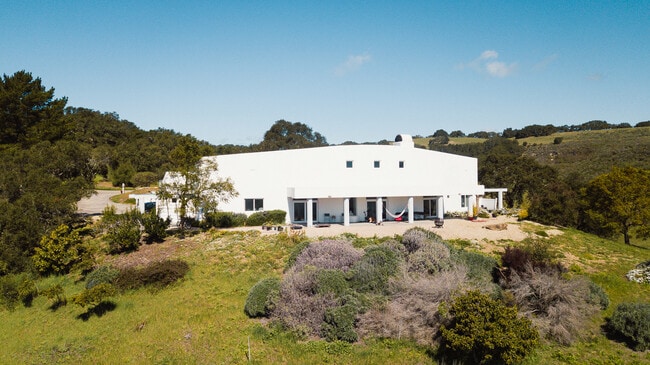
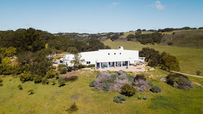
This Property Is For Sale
NEARBY LISTINGS FOR SALE OR LEASE
-
-
View all Morro Bay listings for sale on LoopNet.com
Property Detail
1820 Atascadero Rd
San Luis Obispo-Paso Robles, CA
Rancho Moro & Cayucos
920-000-979
PM 64/24-26 PAR 2
Sfr
San Luis Obispo
2024
California
2025
Coastal SLO
010603
San Luis Obispo/Paso Robles
3,724 SF
DEMOGRAPHICS near 1820 Atascadero Rd
1 Mile
3 Mile
5 Mile
2024 Total Population
65
11,191
16,982
2029 Population
61
11,474
17,552
Pop Growth 2024-2029
(6.15%)
+ 2.53%
+ 3.36%
Average Age
45
49
49
2024 Total Households
25
5,132
7,780
HH Growth 2024-2029
(4.00%)
+ 2.30%
+ 3.24%
Median Household Inc
$80,000
$85,478
$83,863
Avg Household Size
2.40
2.10
2.10
2024 Avg HH Vehicles
3.00
2.00
2.00
Median Home Value
$1,075,000
$785,979
$812,588
Median Year Built
1982
1974
1974
Nearby Places
Map Layers
Map Styles
 Street
 Aerial
- Restaurants
- Banks
- Shops
- Fitness
- Groceries
PUBLIC TRANSPORTATION
AIRPORT
San Luis County Regional
DRIVE
WALK
Distance
San Luis County Regional
40 min
22.1 mi
Freight Ports
The Port of Hueneme
DRIVE
WALK
Distance
The Port of Hueneme
197 min
150.1 mi
Nearby Properties
Address
Land Use
TOTAL SIZE
Lot Size
Zoning
Address
Land Use
TOTAL SIZE
Lot Size
Zoning
90.32 AC
Address
Land Use
TOTAL SIZE
Lot Size
Zoning
49,089 SF
1.99 AC
CVS
Address
Land Use
TOTAL SIZE
Lot Size
Zoning
4,266 SF
7.81 AC
Address
Land Use
TOTAL SIZE
Lot Size
Zoning
47,906 SF
4.49 AC
C1
Address
Land Use
TOTAL SIZE
Lot Size
Zoning
21,672 SF
1 AC
R2
Address
Land Use
TOTAL SIZE
Lot Size
Zoning
3,128 SF
0.14 AC
RSF
Address
Land Use
TOTAL SIZE
Lot Size
Zoning
16,986 SF
1.72 AC
CVS
Address
Land Use
TOTAL SIZE
Lot Size
Zoning
3,684 SF
9.96 AC
R3
Address
Land Use
TOTAL SIZE
Lot Size
Zoning
14,867 SF
0.69 AC
PD
Address
Land Use
TOTAL SIZE
Lot Size
Zoning
16,247 SF
0.40 AC
C1
Address
Land Use
TOTAL SIZE
Lot Size
Zoning
2,600 SF
0.08 AC
RSF
Address
Land Use
TOTAL SIZE
Lot Size
Zoning
952 SF
350 AC
AG
Address
Land Use
TOTAL SIZE
Lot Size
Zoning
14,220 SF
1.03 AC
C1
Address
Land Use
TOTAL SIZE
Lot Size
Zoning
1,144 SF
97.60 AC
AG
Address
Land Use
TOTAL SIZE
Lot Size
Zoning
23,636 SF
2.57 AC
C1
Address
Land Use
TOTAL SIZE
Lot Size
Zoning
2,074 SF
0.10 AC
10
Address
Land Use
TOTAL SIZE
Lot Size
Zoning
2,926 SF
0.10 AC
RSF
Address
Land Use
TOTAL SIZE
Lot Size
Zoning
7,279 SF
1.12 AC
CT
Address
Land Use
TOTAL SIZE
Lot Size
Zoning
2,466 SF
0.10 AC
10
Address
Land Use
TOTAL SIZE
Lot Size
Zoning
21,000 SF
3.16 AC
Address
Land Use
TOTAL SIZE
Lot Size
Zoning
4,476 SF
0.24 AC
R1
Address
Land Use
TOTAL SIZE
Lot Size
Zoning
2,037 SF
0.11 AC
R1
Address
Land Use
TOTAL SIZE
Lot Size
Zoning
2,159 SF
0.09 AC
RSF
Address
Land Use
TOTAL SIZE
Lot Size
Zoning
852 SF
2.31 AC
60
Address
Land Use
TOTAL SIZE
Lot Size
Zoning
2,840 SF
0.25 AC
R1
Address
Land Use
TOTAL SIZE
Lot Size
Zoning
7,809 SF
110 AC
AG
Address
Land Use
TOTAL SIZE
Lot Size
Zoning
2,892 SF
236 AC
AG
Address
Land Use
TOTAL SIZE
Lot Size
Zoning
1,543 SF
0.09 AC
RSF
Address
Land Use
TOTAL SIZE
Lot Size
Zoning
2,310 SF
0.16 AC
R1
Address
Land Use
TOTAL SIZE
Lot Size
Zoning
2,177 SF
0.49 AC
R1
The World's #1 Commercial Real Estate Marketplace
Connect with us
© 2026 CoStar Group
The information above has been obtained from sources believed reliable. While we do not doubt its accuracy we have not verified it and make no guarantee, warranty or representation about it. It is your responsibility to independently confirm its accuracy and completeness. Any projections, opinions, assumptions, or estimates used are for example only and do not represent the current or future performance of the property. The value of this transaction to you depends on tax and other factors which should be evaluated by your tax, financial, and legal advisors. You and your advisors should conduct a careful, independent investigation of the property to determine to your satisfaction the suitability of the property for your needs.