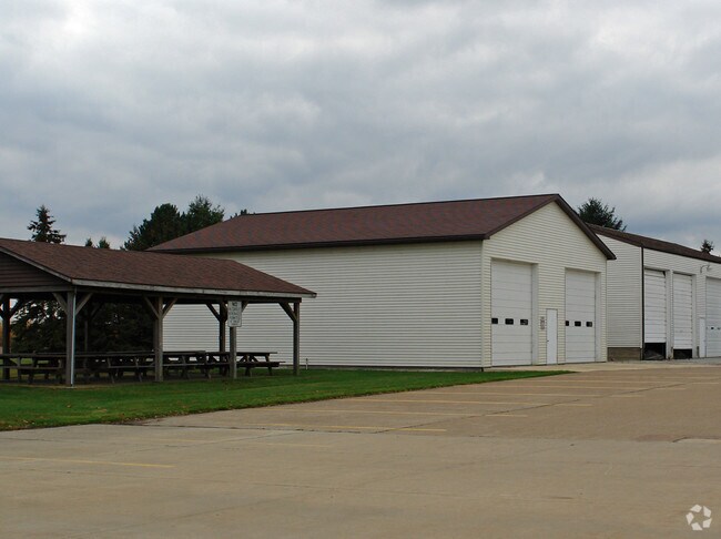
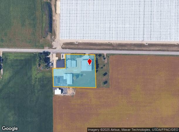
Property Record
1820 Bogart Rd, Huron, OH 44839

Property Detail
1820 Bogart Rd
39-63005-000
22 6 2 20 NW COR
Policefirecivildefense
ERIE
B and X Area of moderate flood hazard, usually the area between the limits of the 100-year and 500-year floods.
Ohio
2024
2.80 AC
2024
Erie County
040400
Cleveland
10,000 SF
Sandusky, OH
NEARBY LISTINGS FOR SALE OR LEASE
-
-
View all Huron listings for sale on LoopNet.com
DEMOGRAPHICS near 1820 Bogart Rd
1 mile
3 mile
5 mile
2025 Total Population
129
9,744
19,386
2030 Population
127
9,683
19,200
Pop Growth 2025-2030
(1.55%)
(0.63%)
(0.96%)
Average Age
49
47
46
2025 Total Households
52
4,260
8,337
HH Growth 2025-2030
(1.92%)
(0.77%)
(1.14%)
Median Household Inc
$69,999
$66,716
$67,584
Avg Household Size
2.20
2.20
2.20
2025 Avg HH Vehicles
2.00
2.00
2.00
Median Home Value
$230,555
$237,423
$235,022
Median Year Built
1981
1975
1975
Nearby Places
Map Layers
Map Styles
 Street
 Aerial
Transit
 Traffic
 Biking
Places
Listings with unknown addresses are not visible on the map
- Restaurants
- Banks
- Shops
- Fitness
- Groceries
PUBLIC TRANSPORTATION
COMMUTER RAIL
Drive
Walk
Distance
15 min
8.1 mi
Freight Ports
Drive
Walk
Distance
83 min
64.0 mi
Nearby Properties
Address
Land Use
TOTAL SIZE
Lot Size
Zoning
Address
Land Use
TOTAL SIZE
Lot Size
Zoning
154,180 SF
36.19 AC
Address
Land Use
TOTAL SIZE
Lot Size
Zoning
178,770 SF
69.49 AC
Address
Land Use
TOTAL SIZE
Lot Size
Zoning
16.20 AC
Address
Land Use
TOTAL SIZE
Lot Size
Zoning
39,530 SF
40.89 AC
Address
Land Use
TOTAL SIZE
Lot Size
Zoning
274,374 SF
94.71 AC
Address
Land Use
TOTAL SIZE
Lot Size
Zoning
3,440 SF
40 AC
Address
Land Use
TOTAL SIZE
Lot Size
Zoning
16,486 SF
12.95 AC
Address
Land Use
TOTAL SIZE
Lot Size
Zoning
38,684 SF
15.59 AC
Address
Land Use
TOTAL SIZE
Lot Size
Zoning
29,618 SF
4.41 AC
Address
Land Use
TOTAL SIZE
Lot Size
Zoning
53,050 SF
51.38 AC
Address
Land Use
TOTAL SIZE
Lot Size
Zoning
23,687 SF
12.68 AC
Address
Land Use
TOTAL SIZE
Lot Size
Zoning
81,165 SF
15.25 AC
Address
Land Use
TOTAL SIZE
Lot Size
Zoning
24,622 SF
25 AC
Address
Land Use
TOTAL SIZE
Lot Size
Zoning
68,424 SF
16.05 AC
Address
Land Use
TOTAL SIZE
Lot Size
Zoning
44,557 SF
5 AC
Address
Land Use
TOTAL SIZE
Lot Size
Zoning
3,726 SF
21.01 AC
Address
Land Use
TOTAL SIZE
Lot Size
Zoning
46,000 SF
8.36 AC
Address
Land Use
TOTAL SIZE
Lot Size
Zoning
55,869 SF
9.62 AC
Address
Land Use
TOTAL SIZE
Lot Size
Zoning
5.51 AC
Address
Land Use
TOTAL SIZE
Lot Size
Zoning
48.91 AC
Address
Land Use
TOTAL SIZE
Lot Size
Zoning
47,175 SF
4.27 AC
Address
Land Use
TOTAL SIZE
Lot Size
Zoning
6,236 SF
9.86 AC
Address
Land Use
TOTAL SIZE
Lot Size
Zoning
41,793 SF
2.56 AC
Address
Land Use
TOTAL SIZE
Lot Size
Zoning
27,973 SF
6.49 AC
Address
Land Use
TOTAL SIZE
Lot Size
Zoning
27,342 SF
10 AC
Address
Land Use
TOTAL SIZE
Lot Size
Zoning
312.63 AC
Address
Land Use
TOTAL SIZE
Lot Size
Zoning
44,562 SF
5.88 AC
Address
Land Use
TOTAL SIZE
Lot Size
Zoning
10,516 SF
2.93 AC
Address
Land Use
TOTAL SIZE
Lot Size
Zoning
11,235 SF
0.81 AC
Address
Land Use
TOTAL SIZE
Lot Size
Zoning
11,095 SF
0.80 AC
The World's #1 Commercial Real Estate Marketplace
Connect with us
© 2026 CoStar Group
The information above has been obtained from sources believed reliable. While we do not doubt its accuracy we have not verified it and make no guarantee, warranty or representation about it. It is your responsibility to independently confirm its accuracy and completeness. Any projections, opinions, assumptions, or estimates used are for example only and do not represent the current or future performance of the property. The value of this transaction to you depends on tax and other factors which should be evaluated by your tax, financial, and legal advisors. You and your advisors should conduct a careful, independent investigation of the property to determine to your satisfaction the suitability of the property for your needs.