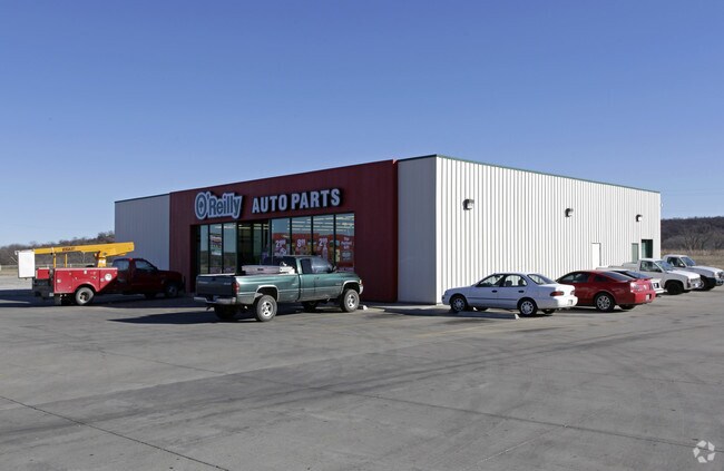
Property Record
1820 E Main St, Pawhuska, OK 74056

Property Detail
1820 E Main St
570073610
3-25-9 TR E/2 SE LYING S OF US HWY 60-COMM NE/C SE-W 24.75'-S 05 58 11 W ALG R/W US HWY 60 & ST HWY 99 1281.88'-S 176.23' TO
Wholesaleoutletdiscountstore
Osage
C and X Area of minimal flood hazard, usually depicted on FIRMs as above the 500-year flood level.
Oklahoma
2025
1.03 AC
2025
Osage County
940013
Tulsa
9,020 SF
Tulsa, OK
NEARBY LISTINGS FOR SALE OR LEASE
DEMOGRAPHICS near 1820 E Main St
1 mile
3 mile
5 mile
2025 Total Population
1,515
3,891
4,140
2030 Population
1,591
4,024
4,260
Pop Growth 2025-2030
+ 5.02%
+ 3.42%
+ 2.90%
Average Age
38
40
40
2025 Total Households
629
1,606
1,710
HH Growth 2025-2030
+ 5.09%
+ 3.42%
+ 2.87%
Median Household Inc
$47,363
$53,135
$52,317
Avg Household Size
2.40
2.40
2.40
2025 Avg HH Vehicles
2.00
2.00
2.00
Median Home Value
$92,207
$130,112
$134,261
Median Year Built
1965
1964
1966
Nearby Places
Map Layers
Map Styles
 Street
 Aerial
Layers
 Traffic
 Biking
Places
Listings with unknown addresses are not visible on the map
- Restaurants
- Banks
- Shops
- Fitness
- Groceries
Nearby Properties
Address
Land Use
TOTAL SIZE
Lot Size
Zoning
Address
Land Use
TOTAL SIZE
Lot Size
Zoning
3,459 SF
5 AC
Address
Land Use
TOTAL SIZE
Lot Size
Zoning
20,025 SF
6 AC
Address
Land Use
TOTAL SIZE
Lot Size
Zoning
18,888 SF
6 AC
Address
Land Use
TOTAL SIZE
Lot Size
Zoning
5,632 SF
3.60 AC
Address
Land Use
TOTAL SIZE
Lot Size
Zoning
3,500 SF
2 AC
Address
Land Use
TOTAL SIZE
Lot Size
Zoning
3,780 SF
0.32 AC
Address
Land Use
TOTAL SIZE
Lot Size
Zoning
1,721 SF
0.10 AC
Address
Land Use
TOTAL SIZE
Lot Size
Zoning
2,460 SF
0.72 AC
Address
Land Use
TOTAL SIZE
Lot Size
Zoning
225,320 SF
18.29 AC
Address
Land Use
TOTAL SIZE
Lot Size
Zoning
4,860 SF
1.29 AC
Address
Land Use
TOTAL SIZE
Lot Size
Zoning
4,964 SF
3 AC
Address
Land Use
TOTAL SIZE
Lot Size
Zoning
400 SF
2.40 AC
Address
Land Use
TOTAL SIZE
Lot Size
Zoning
2,400 SF
3 AC
Address
Land Use
TOTAL SIZE
Lot Size
Zoning
420 SF
5 AC
Address
Land Use
TOTAL SIZE
Lot Size
Zoning
68.86 AC
Address
Land Use
TOTAL SIZE
Lot Size
Zoning
1,200 SF
0.52 AC
Address
Land Use
TOTAL SIZE
Lot Size
Zoning
5,412 SF
2.90 AC
Address
Land Use
TOTAL SIZE
Lot Size
Zoning
2,911 SF
1.34 AC
Address
Land Use
TOTAL SIZE
Lot Size
Zoning
1,016 SF
0.39 AC
Address
Land Use
TOTAL SIZE
Lot Size
Zoning
2,250 SF
0.16 AC
Address
Land Use
TOTAL SIZE
Lot Size
Zoning
2,000 SF
0.08 AC
Address
Land Use
TOTAL SIZE
Lot Size
Zoning
9,270 SF
1.14 AC
Address
Land Use
TOTAL SIZE
Lot Size
Zoning
6,657 SF
1.77 AC
Address
Land Use
TOTAL SIZE
Lot Size
Zoning
1,818 SF
2 AC
Address
Land Use
TOTAL SIZE
Lot Size
Zoning
3,168 SF
0.91 AC
Address
Land Use
TOTAL SIZE
Lot Size
Zoning
2,859 SF
81.64 AC
Address
Land Use
TOTAL SIZE
Lot Size
Zoning
16,800 SF
4.03 AC
Address
Land Use
TOTAL SIZE
Lot Size
Zoning
3,294 SF
3 AC
The World's #1 Commercial Real Estate Marketplace
Connect with us
© 2026 CoStar Group
The information above has been obtained from sources believed reliable. While we do not doubt its accuracy we have not verified it and make no guarantee, warranty or representation about it. It is your responsibility to independently confirm its accuracy and completeness. Any projections, opinions, assumptions, or estimates used are for example only and do not represent the current or future performance of the property. The value of this transaction to you depends on tax and other factors which should be evaluated by your tax, financial, and legal advisors. You and your advisors should conduct a careful, independent investigation of the property to determine to your satisfaction the suitability of the property for your needs.