Property Record
1820 Mindy St, Tea, SD 57064
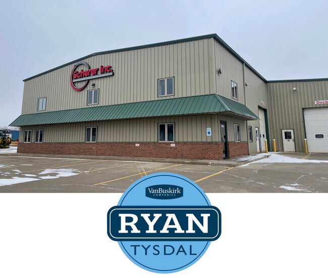


Property Detail
1820 Mindy St
Sioux Falls, SD-MN
Hagedorn Industrial
240.92.01.003
TEA - HAGEDORN IND PARK ADD SE14 - LOT 3 - BLK 1 - 25-100-51
Commercialnec
Lincoln
X
South Dakota
46099C0625D
3
2024
1.25 AC
2024
Sioux Falls
010115
Other Market Areas
NEARBY LISTINGS FOR SALE OR LEASE
DEMOGRAPHICS near 1820 Mindy St
1 mile
3 mile
5 mile
2024 Total Population
987
20,766
66,680
2029 Population
1,223
25,255
77,548
Pop Growth 2024-2029
+ 23.91%
+ 21.62%
+ 16.30%
Average Age
33
34
37
2024 Total Households
330
7,410
26,539
HH Growth 2024-2029
+ 24.24%
+ 21.88%
+ 16.12%
Median Household Inc
$95,607
$88,917
$81,232
Avg Household Size
3.00
2.80
2.50
2024 Avg HH Vehicles
2.00
2.00
2.00
Median Home Value
$286,144
$269,899
$274,458
Median Year Built
2007
2006
2002
Nearby Places
Map Layers
Map Styles
 Street
 Aerial
Transit
 Traffic
 Biking
Places
Listings with unknown addresses are not visible on the map
- Restaurants
- Banks
- Shops
- Fitness
- Groceries
PUBLIC TRANSPORTATION
AIRPORT
Joe Foss Field
Drive
Walk
Distance
Joe Foss Field
21 min
13.2 mi
SALE & LEASE HISTORY
LISTING DATE
SALE/LEASE

Feb 16, 2022
For Sale
Nearby Properties
Address
Land Use
TOTAL SIZE
Lot Size
Zoning
Address
Land Use
TOTAL SIZE
Lot Size
Zoning
8.80 AC
MUNICIPALI
Address
Land Use
TOTAL SIZE
Lot Size
Zoning
8.51 AC
MUNICIPALI
Address
Land Use
TOTAL SIZE
Lot Size
Zoning
9.57 AC
MUNICIPALI
Address
Land Use
TOTAL SIZE
Lot Size
Zoning
11.13 AC
MUNICIPALI
Address
Land Use
TOTAL SIZE
Lot Size
Zoning
8.65 AC
MUNICIPALI
Address
Land Use
TOTAL SIZE
Lot Size
Zoning
9.56 AC
MUNICIPALI
Address
Land Use
TOTAL SIZE
Lot Size
Zoning
16.45 AC
MUNICIPALI
Address
Land Use
TOTAL SIZE
Lot Size
Zoning
6.51 AC
MUNICIPALI
Address
Land Use
TOTAL SIZE
Lot Size
Zoning
5.27 AC
MUNICIPALI
Address
Land Use
TOTAL SIZE
Lot Size
Zoning
4.36 AC
MUNICIPALI
Address
Land Use
TOTAL SIZE
Lot Size
Zoning
11.80 AC
I-1 LIGHT
Address
Land Use
TOTAL SIZE
Lot Size
Zoning
4.25 AC
MUNICIPALI
Address
Land Use
TOTAL SIZE
Lot Size
Zoning
126.55 AC
PD PLANNED
Address
Land Use
TOTAL SIZE
Lot Size
Zoning
4.39 AC
MUNICIPALI
Address
Land Use
TOTAL SIZE
Lot Size
Zoning
5.12 AC
MUNICIPALI
Address
Land Use
TOTAL SIZE
Lot Size
Zoning
4.53 AC
MUNICIPALI
Address
Land Use
TOTAL SIZE
Lot Size
Zoning
8.28 AC
MUNICIPALI
Address
Land Use
TOTAL SIZE
Lot Size
Zoning
3.82 AC
MUNICIPALI
Address
Land Use
TOTAL SIZE
Lot Size
Zoning
5.43 AC
MUNICIPALI
Address
Land Use
TOTAL SIZE
Lot Size
Zoning
11.26 AC
MUNICIPALI
Address
Land Use
TOTAL SIZE
Lot Size
Zoning
3.56 AC
MUNICIPALI
Address
Land Use
TOTAL SIZE
Lot Size
Zoning
4.62 AC
MUNICIPALI
Address
Land Use
TOTAL SIZE
Lot Size
Zoning
7 AC
I-1 LIGHT
Address
Land Use
TOTAL SIZE
Lot Size
Zoning
2.68 AC
MUNICIPALI
Address
Land Use
TOTAL SIZE
Lot Size
Zoning
5.14 AC
MUNICIPALI
Address
Land Use
TOTAL SIZE
Lot Size
Zoning
2.50 AC
MUNICIPALI
Address
Land Use
TOTAL SIZE
Lot Size
Zoning
2.48 AC
MUNICIPALI
Address
Land Use
TOTAL SIZE
Lot Size
Zoning
4.04 AC
C COMMERCI
Address
Land Use
TOTAL SIZE
Lot Size
Zoning
2.47 AC
MUNICIPALI
Address
Land Use
TOTAL SIZE
Lot Size
Zoning
1.56 AC
MUNICIPALI
The World's #1 Commercial Real Estate Marketplace
Connect with us
© 2026 CoStar Group
The information above has been obtained from sources believed reliable. While we do not doubt its accuracy we have not verified it and make no guarantee, warranty or representation about it. It is your responsibility to independently confirm its accuracy and completeness. Any projections, opinions, assumptions, or estimates used are for example only and do not represent the current or future performance of the property. The value of this transaction to you depends on tax and other factors which should be evaluated by your tax, financial, and legal advisors. You and your advisors should conduct a careful, independent investigation of the property to determine to your satisfaction the suitability of the property for your needs.