Property Record
1820 Ridgeway E, Montgomery, AL 36110


Save to a Folder
{{folder.Name}}
{{folder.ListingIds.length}} Properties
{{folder.ListingIds.length}} Property
Create a New Folder
Property Detail
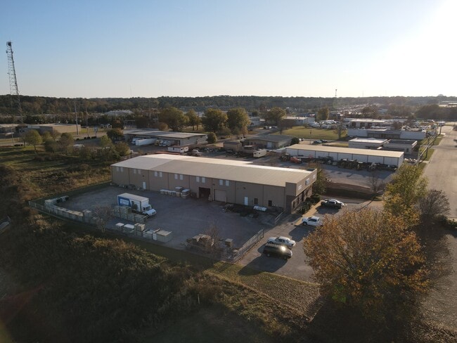
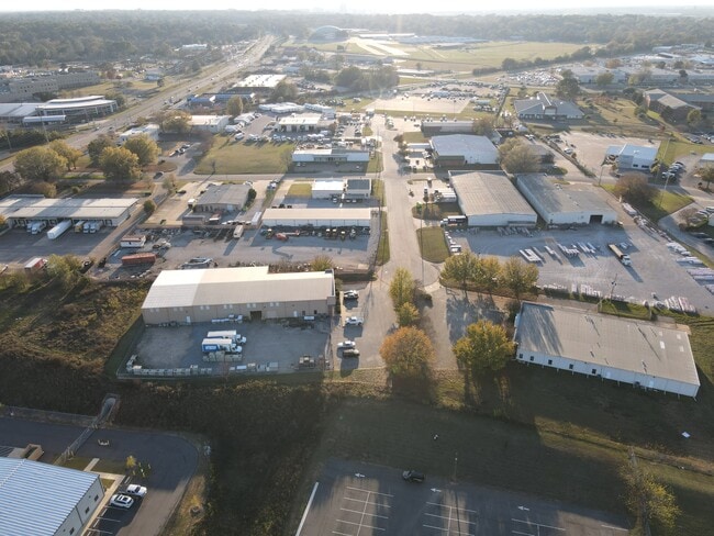
1820 Ridgeway E
04-08-33-1-000-020.000
0408331000020000
Publicstorage
MONTGOMERY
M-1
Alabama
B and X Area of moderate flood hazard, usually the area between the limits of the 100-year and 500-year floods.
5
2025
2.45 AC
2025
North Montgomery
002500
Montgomery
15,039 SF
Montgomery, AL
NEARBY LISTINGS FOR SALE OR LEASE
DEMOGRAPHICS near 1820 Ridgeway E
1 mile
3 mile
5 mile
2025 Total Population
3,422
37,072
88,697
2030 Population
3,375
36,721
87,928
Pop Growth 2025-2030
(1.37%)
(0.95%)
(0.87%)
Average Age
36
39
38
2025 Total Households
1,226
15,193
36,704
HH Growth 2025-2030
(1.63%)
(1.06%)
(0.86%)
Median Household Inc
$62,093
$52,483
$57,703
Avg Household Size
2.50
2.30
2.20
2025 Avg HH Vehicles
2.00
2.00
2.00
Median Home Value
$137,954
$122,426
$152,462
Median Year Built
1975
1965
1972
Nearby Places
Map Layers
Map Styles
 Street
 Aerial
Layers
 Traffic
 Biking
Places
Listings with unknown addresses are not visible on the map
- Restaurants
- Banks
- Shops
- Fitness
- Groceries
PUBLIC TRANSPORTATION
AIRPORT
Montgomery Regional (Dannelly Field)
Drive
Walk
Distance
Montgomery Regional (Dannelly Field)
22 min
13.5 mi
SALE & LEASE HISTORY
LISTING DATE
SALE/LEASE

Nov 25, 2025
For Sale
Nearby Properties
Address
Land Use
TOTAL SIZE
Lot Size
Zoning
Address
Land Use
TOTAL SIZE
Lot Size
Zoning
427,546 SF
37.68 AC
M-1
Address
Land Use
TOTAL SIZE
Lot Size
Zoning
216,654 SF
26.49 AC
B-2
Address
Land Use
TOTAL SIZE
Lot Size
Zoning
591,904 SF
26 AC
M-1
Address
Land Use
TOTAL SIZE
Lot Size
Zoning
122,119 SF
21 AC
R-75-S
Address
Land Use
TOTAL SIZE
Lot Size
Zoning
3,221 SF
14.41 AC
R-65-M
Address
Land Use
TOTAL SIZE
Lot Size
Zoning
96,168 SF
95.16 AC
INST
Address
Land Use
TOTAL SIZE
Lot Size
Zoning
30,386 SF
10.12 AC
B-2
Address
Land Use
TOTAL SIZE
Lot Size
Zoning
187,340 SF
22.80 AC
M-1
Address
Land Use
TOTAL SIZE
Lot Size
Zoning
30,747 SF
21.58 AC
M-1
Address
Land Use
TOTAL SIZE
Lot Size
Zoning
67,643 SF
12.82 AC
M-1
Address
Land Use
TOTAL SIZE
Lot Size
Zoning
244,062 SF
12.94 AC
M-1
Address
Land Use
TOTAL SIZE
Lot Size
Zoning
18,557 SF
9.41 AC
R-75-S
Address
Land Use
TOTAL SIZE
Lot Size
Zoning
138,670 SF
3.89 AC
B-2
Address
Land Use
TOTAL SIZE
Lot Size
Zoning
1,910 SF
11.09 AC
R-65-M
Address
Land Use
TOTAL SIZE
Lot Size
Zoning
47,345 SF
8.44 AC
B-2
Address
Land Use
TOTAL SIZE
Lot Size
Zoning
25,652 SF
5.88 AC
T5
Address
Land Use
TOTAL SIZE
Lot Size
Zoning
187,113 SF
15 AC
M-1
Address
Land Use
TOTAL SIZE
Lot Size
Zoning
69,372 SF
11.79 AC
M-1
Address
Land Use
TOTAL SIZE
Lot Size
Zoning
1,665 SF
6.80 AC
R-65-M
Address
Land Use
TOTAL SIZE
Lot Size
Zoning
12,891 SF
35.50 AC
M-1
Address
Land Use
TOTAL SIZE
Lot Size
Zoning
127,232 SF
9.61 AC
M-1
Address
Land Use
TOTAL SIZE
Lot Size
Zoning
292,718 SF
31 AC
M-1
Address
Land Use
TOTAL SIZE
Lot Size
Zoning
64,837 SF
8.30 AC
INST
Address
Land Use
TOTAL SIZE
Lot Size
Zoning
74,046 SF
9.40 AC
INST
Address
Land Use
TOTAL SIZE
Lot Size
Zoning
175,504 SF
16 AC
M-1
Address
Land Use
TOTAL SIZE
Lot Size
Zoning
286 SF
38.40 AC
M-1
Address
Land Use
TOTAL SIZE
Lot Size
Zoning
10,847 SF
3.57 AC
B-3
Address
Land Use
TOTAL SIZE
Lot Size
Zoning
30,752 SF
1.13 AC
R-100
Address
Land Use
TOTAL SIZE
Lot Size
Zoning
45,643 SF
3.70 AC
R-60-S
Address
Land Use
TOTAL SIZE
Lot Size
Zoning
53,415 SF
5.50 AC
R-65-S
The World's #1 Commercial Real Estate Marketplace
Connect with us
© 2026 CoStar Group
The information above has been obtained from sources believed reliable. While we do not doubt its accuracy we have not verified it and make no guarantee, warranty or representation about it. It is your responsibility to independently confirm its accuracy and completeness. Any projections, opinions, assumptions, or estimates used are for example only and do not represent the current or future performance of the property. The value of this transaction to you depends on tax and other factors which should be evaluated by your tax, financial, and legal advisors. You and your advisors should conduct a careful, independent investigation of the property to determine to your satisfaction the suitability of the property for your needs.