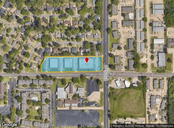
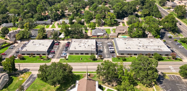
Property Record
1820 Shiloh Rd, Tyler, TX 75703
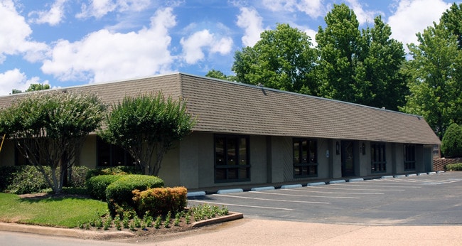
This Property Is For Sale
NEARBY LISTINGS FOR SALE OR LEASE
Property Detail
1820 Shiloh Rd
Tyler, TX
Hillshire Heights
1-50000-1032-24-011000
HILLSHIRE HEIGHTSBLOCK 1032-X LOT 11 & 12
Commercialofficeresidentialmixeduse
Smith
X
Texas
48423C0370D
11-12
2024
2.76 AC
2025
Tyler & Longview
002004
Other Market Areas
19,824 SF
DEMOGRAPHICS near 1820 Shiloh Rd
1 Mile
3 Mile
5 Mile
2024 Total Population
10,763
61,436
103,454
2029 Population
11,649
66,622
112,565
Pop Growth 2024-2029
+ 8.23%
+ 8.44%
+ 8.81%
Average Age
37
39
39
2024 Total Households
4,729
26,087
41,451
HH Growth 2024-2029
+ 7.57%
+ 7.93%
+ 8.29%
Median Household Inc
$55,918
$65,268
$61,257
Avg Household Size
2.20
2.20
2.30
2024 Avg HH Vehicles
2.00
2.00
2.00
Median Home Value
$233,056
$215,196
$208,969
Median Year Built
1985
1984
1982
Nearby Places
Map Layers
Map Styles
 Street
 Aerial
- Restaurants
- Banks
- Shops
- Fitness
- Groceries
PUBLIC TRANSPORTATION
AIRPORT
Tyler Pounds Regional
DRIVE
WALK
Distance
Tyler Pounds Regional
21 min
12.6 mi
Nearby Properties
Address
Land Use
TOTAL SIZE
Lot Size
Zoning
Address
Land Use
TOTAL SIZE
Lot Size
Zoning
22,500 SF
214.44 AC
R1A
Address
Land Use
TOTAL SIZE
Lot Size
Zoning
1.47 AC
RMF
Address
Land Use
TOTAL SIZE
Lot Size
Zoning
33,409 SF
151.32 AC
M2
Address
Land Use
TOTAL SIZE
Lot Size
Zoning
9.98 AC
Address
Land Use
TOTAL SIZE
Lot Size
Zoning
18.37 AC
R1A
Address
Land Use
TOTAL SIZE
Lot Size
Zoning
403,396 SF
45.40 AC
C4
Address
Land Use
TOTAL SIZE
Lot Size
Zoning
49,544 SF
28.64 AC
Address
Land Use
TOTAL SIZE
Lot Size
Zoning
168,390 SF
7.51 AC
Address
Land Use
TOTAL SIZE
Lot Size
Zoning
16.53 AC
Address
Land Use
TOTAL SIZE
Lot Size
Zoning
84,400 SF
13.98 AC
Address
Land Use
TOTAL SIZE
Lot Size
Zoning
5,068 SF
18.35 AC
RMF
Address
Land Use
TOTAL SIZE
Lot Size
Zoning
25 AC
INT
Address
Land Use
TOTAL SIZE
Lot Size
Zoning
3,149 SF
16.15 AC
RMF
Address
Land Use
TOTAL SIZE
Lot Size
Zoning
4,349 SF
33.26 AC
RMF
Address
Land Use
TOTAL SIZE
Lot Size
Zoning
213,323 SF
1.21 AC
Address
Land Use
TOTAL SIZE
Lot Size
Zoning
3,052 SF
9.20 AC
PMF
Address
Land Use
TOTAL SIZE
Lot Size
Zoning
43,165 SF
7.33 AC
Address
Land Use
TOTAL SIZE
Lot Size
Zoning
20,071 SF
7.43 AC
Address
Land Use
TOTAL SIZE
Lot Size
Zoning
3,189 SF
11.17 AC
RMF
Address
Land Use
TOTAL SIZE
Lot Size
Zoning
66.86 AC
R1A
Address
Land Use
TOTAL SIZE
Lot Size
Zoning
10.51 AC
Address
Land Use
TOTAL SIZE
Lot Size
Zoning
38,900 SF
20.11 AC
INT
Address
Land Use
TOTAL SIZE
Lot Size
Zoning
75,999 SF
5.09 AC
Address
Land Use
TOTAL SIZE
Lot Size
Zoning
37,536 SF
16.81 AC
RMF
Address
Land Use
TOTAL SIZE
Lot Size
Zoning
8,279 SF
14.06 AC
RMF
Address
Land Use
TOTAL SIZE
Lot Size
Zoning
88,964 SF
11.33 AC
Address
Land Use
TOTAL SIZE
Lot Size
Zoning
111,030 SF
1.02 AC
Address
Land Use
TOTAL SIZE
Lot Size
Zoning
1,867 SF
13.63 AC
RMF
Address
Land Use
TOTAL SIZE
Lot Size
Zoning
3,968 SF
12.04 AC
RMF
Address
Land Use
TOTAL SIZE
Lot Size
Zoning
3,538 SF
9.51 AC
RMF
The World's #1 Commercial Real Estate Marketplace
Connect with us
© 2025 CoStar Group
The information above has been obtained from sources believed reliable. While we do not doubt its accuracy we have not verified it and make no guarantee, warranty or representation about it. It is your responsibility to independently confirm its accuracy and completeness. Any projections, opinions, assumptions, or estimates used are for example only and do not represent the current or future performance of the property. The value of this transaction to you depends on tax and other factors which should be evaluated by your tax, financial, and legal advisors. You and your advisors should conduct a careful, independent investigation of the property to determine to your satisfaction the suitability of the property for your needs.