Property Record
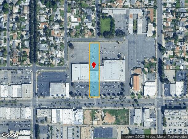
18201 Sherman Way, Reseda, CA 91335
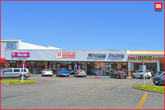
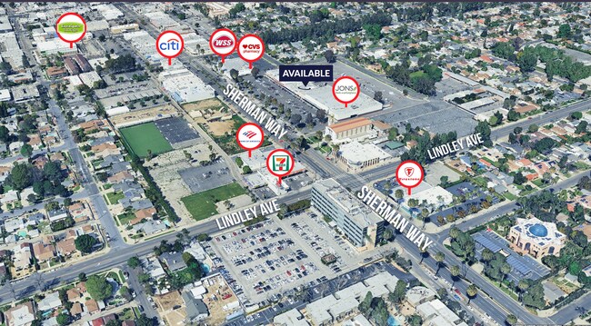
Current Lease Availabilities
NEARBY LISTINGS FOR SALE OR LEASE
Property Detail
18201 Sherman Way
Los Angeles-Long Beach-Glendale, CA
19369
2119-028-015
*TR=19369*E 100 FT OF W 345 FT MEASURED ON S LINE OF LOT 1
Regionalshoppingcenterormallwithanchorstore
Los Angeles
X
California
06037C1285F
1
2024
1.30 AC
2025
Western SFV
131801
Los Angeles
38,125 SF
DEMOGRAPHICS near 18201 Sherman Way
1 Mile
3 Mile
5 Mile
2024 Total Population
36,905
239,302
635,774
2029 Population
35,897
232,785
620,799
Pop Growth 2024-2029
(2.73%)
(2.72%)
(2.36%)
Average Age
39
40
39
2024 Total Households
11,387
80,853
216,616
HH Growth 2024-2029
(2.98%)
(2.93%)
(2.51%)
Median Household Inc
$67,567
$74,835
$74,982
Avg Household Size
3.10
2.80
2.80
2024 Avg HH Vehicles
2.00
2.00
2.00
Median Home Value
$708,055
$746,791
$769,706
Median Year Built
1963
1967
1970
Nearby Places
Map Layers
Map Styles
 Street
 Aerial
- Restaurants
- Banks
- Shops
- Fitness
- Groceries
PUBLIC TRANSPORTATION
COMMUTER RAIL
Northridge (Ventura County Line - Southern California Regional Rail Authority (Metrolink))
DRIVE
WALK
Distance
Northridge (Ventura County Line - Southern California Regional Rail Authority (Metrolink))
8 min
2.9 mi
DRIVE
WALK
Distance
9 min
3.0 mi
AIRPORT
Bob Hope
DRIVE
WALK
Distance
Bob Hope
24 min
10.0 mi
Los Angeles International
DRIVE
WALK
Distance
Los Angeles International
36 min
23.7 mi
Long Beach (Daugherty Field)
DRIVE
WALK
Distance
Long Beach (Daugherty Field)
54 min
41.1 mi
Freight Ports
Port of Long Beach
DRIVE
WALK
Distance
Port of Long Beach
58 min
43.1 mi
Nearby Properties
Address
Land Use
TOTAL SIZE
Lot Size
Zoning
Address
Land Use
TOTAL SIZE
Lot Size
Zoning
461,531 SF
11.22 AC
LAC2
Address
Land Use
TOTAL SIZE
Lot Size
Zoning
393,032 SF
70.93 AC
LAM2
Address
Land Use
TOTAL SIZE
Lot Size
Zoning
300,266 SF
7.29 AC
LAR4
Address
Land Use
TOTAL SIZE
Lot Size
Zoning
546,652 SF
4.27 AC
LAC2
Address
Land Use
TOTAL SIZE
Lot Size
Zoning
439,930 SF
22.16 AC
LAM2
Address
Land Use
TOTAL SIZE
Lot Size
Zoning
257,873 SF
2.52 AC
Address
Land Use
TOTAL SIZE
Lot Size
Zoning
260,991 SF
3.32 AC
LAC2
Address
Land Use
TOTAL SIZE
Lot Size
Zoning
191,058 SF
5.31 AC
LAR3
Address
Land Use
TOTAL SIZE
Lot Size
Zoning
273,911 SF
8.40 AC
LARA
Address
Land Use
TOTAL SIZE
Lot Size
Zoning
237,082 SF
2.17 AC
LARA
Address
Land Use
TOTAL SIZE
Lot Size
Zoning
318,083 SF
2.36 AC
LAC2
Address
Land Use
TOTAL SIZE
Lot Size
Zoning
219,126 SF
6.06 AC
LAR1
Address
Land Use
TOTAL SIZE
Lot Size
Zoning
216,121 SF
6.10 AC
LAC4
Address
Land Use
TOTAL SIZE
Lot Size
Zoning
281,941 SF
9.10 AC
LAC4
Address
Land Use
TOTAL SIZE
Lot Size
Zoning
111,876 SF
3.72 AC
LAC2
Address
Land Use
TOTAL SIZE
Lot Size
Zoning
210,268 SF
3.82 AC
LAP
Address
Land Use
TOTAL SIZE
Lot Size
Zoning
116,961 SF
3.60 AC
LAR3
Address
Land Use
TOTAL SIZE
Lot Size
Zoning
355,475 SF
6.46 AC
LARA
Address
Land Use
TOTAL SIZE
Lot Size
Zoning
117,604 SF
2.65 AC
LAR3
Address
Land Use
TOTAL SIZE
Lot Size
Zoning
173,231 SF
1.58 AC
LAR3
Address
Land Use
TOTAL SIZE
Lot Size
Zoning
657,547 SF
6.85 AC
LAC4
Address
Land Use
TOTAL SIZE
Lot Size
Zoning
290,254 SF
11.53 AC
LAM2
Address
Land Use
TOTAL SIZE
Lot Size
Zoning
138,260 SF
1.29 AC
LAC2
Address
Land Use
TOTAL SIZE
Lot Size
Zoning
353,563 SF
9.37 AC
LAC2
Address
Land Use
TOTAL SIZE
Lot Size
Zoning
323,511 SF
7.58 AC
LAC1
Address
Land Use
TOTAL SIZE
Lot Size
Zoning
250,462 SF
1.85 AC
LAP
Address
Land Use
TOTAL SIZE
Lot Size
Zoning
124,534 SF
7.47 AC
LAC2
Address
Land Use
TOTAL SIZE
Lot Size
Zoning
653,215 SF
15.49 AC
LAC4
The World's #1 Commercial Real Estate Marketplace
Connect with us
© 2026 CoStar Group
The information above has been obtained from sources believed reliable. While we do not doubt its accuracy we have not verified it and make no guarantee, warranty or representation about it. It is your responsibility to independently confirm its accuracy and completeness. Any projections, opinions, assumptions, or estimates used are for example only and do not represent the current or future performance of the property. The value of this transaction to you depends on tax and other factors which should be evaluated by your tax, financial, and legal advisors. You and your advisors should conduct a careful, independent investigation of the property to determine to your satisfaction the suitability of the property for your needs.