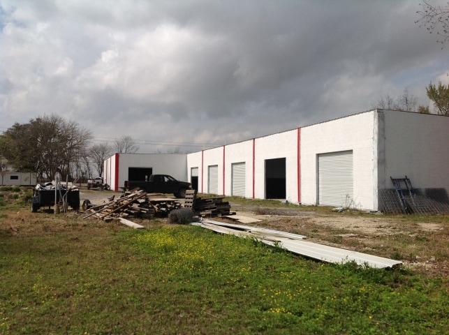
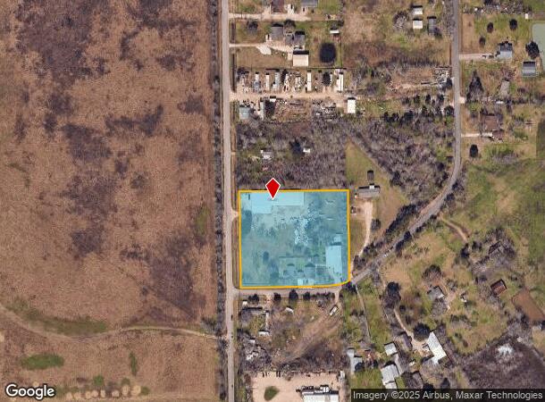
Property Record
18202 Timothy St, Pearland, TX 77584

NEARBY LISTINGS FOR SALE OR LEASE
Property Detail
18202 Timothy St
0293-0020-111
H T & B R R
Commercialnec
A0293 H T & B R R TRACT 3A1X-3A1BB-3A1U-3A1G (ROY ACRES SOUTH 1) ACRES 3.6
X
Brazoria
48039C0043K
Texas
2024
3.60 AC
2025
South Hwy 35
660902
Houston
18,322 SF
Houston-The Woodlands-Sugar Land, TX
DEMOGRAPHICS near 18202 Timothy St
1 Mile
3 Mile
5 Mile
2024 Total Population
3,548
25,638
103,252
2029 Population
3,993
28,381
113,255
Pop Growth 2024-2029
+ 12.54%
+ 10.70%
+ 9.69%
Average Age
34
36
37
2024 Total Households
1,032
8,061
34,785
HH Growth 2024-2029
+ 12.69%
+ 10.84%
+ 9.81%
Median Household Inc
$66,294
$102,074
$101,928
Avg Household Size
3.20
3.10
2.90
2024 Avg HH Vehicles
2.00
2.00
2.00
Median Home Value
$241,262
$284,459
$285,281
Median Year Built
1996
2000
1996
Nearby Places
Map Layers
Map Styles
 Street
 Aerial
- Restaurants
- Banks
- Shops
- Fitness
- Groceries
PUBLIC TRANSPORTATION
AIRPORT
William P Hobby
DRIVE
WALK
Distance
William P Hobby
23 min
10.7 mi
Freight Ports
Port of Houston
DRIVE
WALK
Distance
Port of Houston
34 min
18.9 mi
SALE & LEASE HISTORY
LISTING DATE
SALE/LEASE

Sep 12, 2018
For Lease
Nov 08, 2021
For Lease
Nearby Properties
Address
Land Use
TOTAL SIZE
Lot Size
Zoning
Address
Land Use
TOTAL SIZE
Lot Size
Zoning
40.52 AC
0017
Address
Land Use
TOTAL SIZE
Lot Size
Zoning
83.37 AC
0004
Address
Land Use
TOTAL SIZE
Lot Size
Zoning
64.56 AC
0016
Address
Land Use
TOTAL SIZE
Lot Size
Zoning
7.42 AC
Address
Land Use
TOTAL SIZE
Lot Size
Zoning
113,376 SF
9.80 AC
Address
Land Use
TOTAL SIZE
Lot Size
Zoning
49.29 AC
0007
Address
Land Use
TOTAL SIZE
Lot Size
Zoning
19.61 AC
Address
Land Use
TOTAL SIZE
Lot Size
Zoning
67,000 SF
28.97 AC
Address
Land Use
TOTAL SIZE
Lot Size
Zoning
Address
Land Use
TOTAL SIZE
Lot Size
Zoning
67,130 SF
17.70 AC
0151
Address
Land Use
TOTAL SIZE
Lot Size
Zoning
9.72 AC
Address
Land Use
TOTAL SIZE
Lot Size
Zoning
27,648 SF
3.23 AC
0009
Address
Land Use
TOTAL SIZE
Lot Size
Zoning
153,736 SF
9.25 AC
Address
Land Use
TOTAL SIZE
Lot Size
Zoning
24,000 SF
3.53 AC
0001
Address
Land Use
TOTAL SIZE
Lot Size
Zoning
39,208 SF
8.03 AC
0060
Address
Land Use
TOTAL SIZE
Lot Size
Zoning
41.07 AC
Address
Land Use
TOTAL SIZE
Lot Size
Zoning
162,100 SF
24.51 AC
0056
Address
Land Use
TOTAL SIZE
Lot Size
Zoning
34,250 SF
6.67 AC
Address
Land Use
TOTAL SIZE
Lot Size
Zoning
47,260 SF
9.80 AC
0146
Address
Land Use
TOTAL SIZE
Lot Size
Zoning
128.92 AC
0028
Address
Land Use
TOTAL SIZE
Lot Size
Zoning
44,800 SF
3.97 AC
Address
Land Use
TOTAL SIZE
Lot Size
Zoning
12,209 SF
2.46 AC
Address
Land Use
TOTAL SIZE
Lot Size
Zoning
37,575 SF
1.27 AC
0011
Address
Land Use
TOTAL SIZE
Lot Size
Zoning
29,230 SF
2.97 AC
Address
Land Use
TOTAL SIZE
Lot Size
Zoning
45,089 SF
5 AC
0007
Address
Land Use
TOTAL SIZE
Lot Size
Zoning
1,830 SF
31.44 AC
Address
Land Use
TOTAL SIZE
Lot Size
Zoning
13.29 AC
Address
Land Use
TOTAL SIZE
Lot Size
Zoning
36,899 SF
4 AC
Address
Land Use
TOTAL SIZE
Lot Size
Zoning
22,502 SF
4.97 AC
Address
Land Use
TOTAL SIZE
Lot Size
Zoning
The World's #1 Commercial Real Estate Marketplace
Connect with us
© 2025 CoStar Group
The information above has been obtained from sources believed reliable. While we do not doubt its accuracy we have not verified it and make no guarantee, warranty or representation about it. It is your responsibility to independently confirm its accuracy and completeness. Any projections, opinions, assumptions, or estimates used are for example only and do not represent the current or future performance of the property. The value of this transaction to you depends on tax and other factors which should be evaluated by your tax, financial, and legal advisors. You and your advisors should conduct a careful, independent investigation of the property to determine to your satisfaction the suitability of the property for your needs.