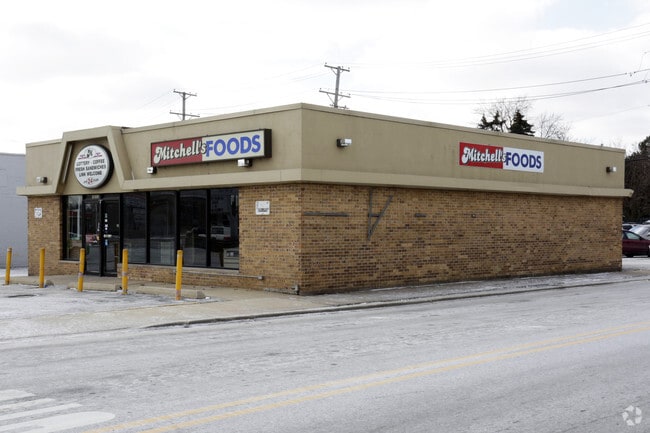
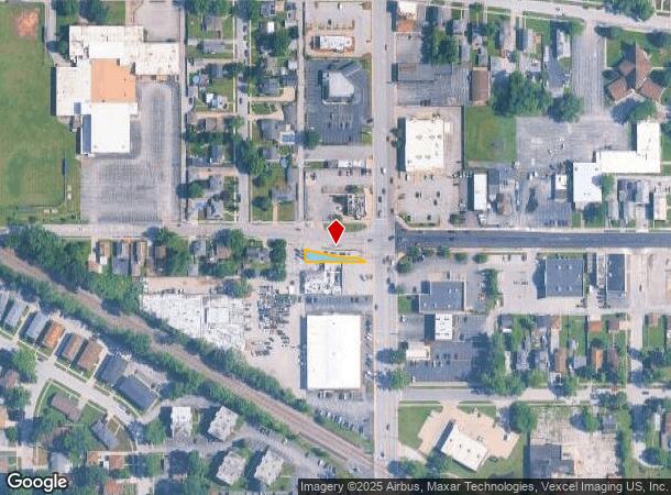
Property Record
18202 Torrence Ave, Lansing, IL 60438

NEARBY LISTINGS FOR SALE OR LEASE
Property Detail
18202 Torrence Ave
29-36-401-035-0000
Cook
Commercialnec
Illinois
X
0.19 AC
17031C0758J
Near South Cook
2023
Chicago
2025
Chicago-Naperville-Elgin, IL-IN
828202
DEMOGRAPHICS near 18202 Torrence Ave
1 mile
3 mile
5 mile
2024 Total Population
12,811
76,147
222,559
2029 Population
12,504
74,235
218,554
Pop Growth 2024-2029
(2.40%)
(2.51%)
(1.80%)
Average Age
40
42
40
2024 Total Households
4,964
29,555
84,416
HH Growth 2024-2029
(2.68%)
(2.81%)
(2.04%)
Median Household Inc
$60,639
$64,767
$61,621
Avg Household Size
2.50
2.50
2.50
2024 Avg HH Vehicles
2.00
2.00
2.00
Median Home Value
$152,880
$163,891
$158,980
Median Year Built
1967
1967
1965
Nearby Places
Map Layers
Map Styles
 Street
 Aerial
Transit
 Traffic
 Biking
Places
Listings with unknown addresses are not visible on the map
- Restaurants
- Banks
- Shops
- Fitness
- Groceries
PUBLIC TRANSPORTATION
COMMUTER RAIL
Dyer Amtrak (Cardinal - Amtrak)
Drive
Walk
Distance
Dyer Amtrak (Cardinal - Amtrak)
11 min
6.2 mi
Hammond Station (South Shore Line - Northern Indiana Commuter Transportation District (South Shore Line))
Drive
Walk
Distance
Hammond Station (South Shore Line - Northern Indiana Commuter Transportation District (South Shore Line))
12 min
6.9 mi
AIRPORT
Chicago Midway International
Drive
Walk
Distance
Chicago Midway International
35 min
23.9 mi
Freight Ports
Port Milwaukee
Drive
Walk
Distance
Port Milwaukee
139 min
110.4 mi
Nearby Properties
Address
Land Use
TOTAL SIZE
Lot Size
Zoning
Address
Land Use
TOTAL SIZE
Lot Size
Zoning
879,191 SF
13.93 AC
Address
Land Use
TOTAL SIZE
Lot Size
Zoning
125,938 SF
13.32 AC
Address
Land Use
TOTAL SIZE
Lot Size
Zoning
350,110 SF
24.01 AC
R33
Address
Land Use
TOTAL SIZE
Lot Size
Zoning
454,750 SF
21.15 AC
Address
Land Use
TOTAL SIZE
Lot Size
Zoning
668,326 SF
26.90 AC
Address
Land Use
TOTAL SIZE
Lot Size
Zoning
197,080 SF
R33
Address
Land Use
TOTAL SIZE
Lot Size
Zoning
24.56 AC
Address
Land Use
TOTAL SIZE
Lot Size
Zoning
97,046 SF
3.36 AC
Address
Land Use
TOTAL SIZE
Lot Size
Zoning
140,360 SF
15 AC
R33
Address
Land Use
TOTAL SIZE
Lot Size
Zoning
135,617 SF
7.80 AC
Address
Land Use
TOTAL SIZE
Lot Size
Zoning
251,700 SF
19.86 AC
Address
Land Use
TOTAL SIZE
Lot Size
Zoning
82,272 SF
12.55 AC
R3
Address
Land Use
TOTAL SIZE
Lot Size
Zoning
52,731 SF
2.24 AC
R33
Address
Land Use
TOTAL SIZE
Lot Size
Zoning
63,711 SF
6.98 AC
Address
Land Use
TOTAL SIZE
Lot Size
Zoning
94,500 SF
2.68 AC
Address
Land Use
TOTAL SIZE
Lot Size
Zoning
68,178 SF
0.64 AC
Address
Land Use
TOTAL SIZE
Lot Size
Zoning
244,310 SF
9.32 AC
Address
Land Use
TOTAL SIZE
Lot Size
Zoning
87,166 SF
7.82 AC
Address
Land Use
TOTAL SIZE
Lot Size
Zoning
106,840 SF
6.62 AC
R33
Address
Land Use
TOTAL SIZE
Lot Size
Zoning
36,704 SF
3.12 AC
Address
Land Use
TOTAL SIZE
Lot Size
Zoning
117,855 SF
8.51 AC
Address
Land Use
TOTAL SIZE
Lot Size
Zoning
47,394 SF
2.11 AC
Address
Land Use
TOTAL SIZE
Lot Size
Zoning
37,450 SF
1.78 AC
Address
Land Use
TOTAL SIZE
Lot Size
Zoning
5.01 AC
Address
Land Use
TOTAL SIZE
Lot Size
Zoning
122,628 SF
9.40 AC
Address
Land Use
TOTAL SIZE
Lot Size
Zoning
91,079 SF
8.93 AC
Address
Land Use
TOTAL SIZE
Lot Size
Zoning
41,928 SF
3.71 AC
Address
Land Use
TOTAL SIZE
Lot Size
Zoning
73,960 SF
3.84 AC
R33
Address
Land Use
TOTAL SIZE
Lot Size
Zoning
65,100 SF
5.50 AC
R33
Address
Land Use
TOTAL SIZE
Lot Size
Zoning
119,082 SF
11.26 AC
The World's #1 Commercial Real Estate Marketplace
Connect with us
© 2026 CoStar Group
The information above has been obtained from sources believed reliable. While we do not doubt its accuracy we have not verified it and make no guarantee, warranty or representation about it. It is your responsibility to independently confirm its accuracy and completeness. Any projections, opinions, assumptions, or estimates used are for example only and do not represent the current or future performance of the property. The value of this transaction to you depends on tax and other factors which should be evaluated by your tax, financial, and legal advisors. You and your advisors should conduct a careful, independent investigation of the property to determine to your satisfaction the suitability of the property for your needs.