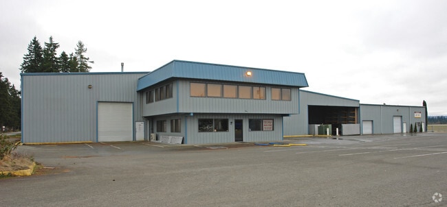
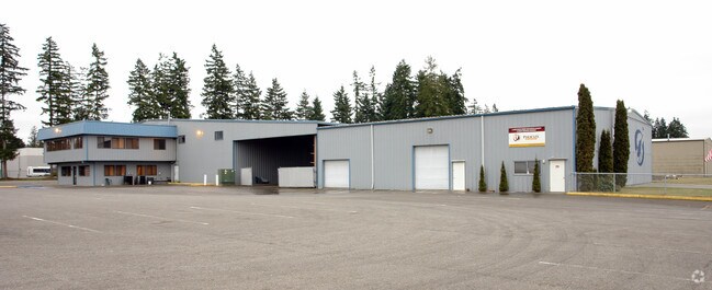
Property Record
18204 59Th Ave Ne, Arlington, WA 98223

NEARBY LISTINGS FOR SALE OR LEASE
Property Detail
18204 59Th Ave Ne
Seattle-Tacoma-Bellevue, WA
Berrywoods Ph 01
310522-002-001-00
SECTION 22 TOWNSHIP 31 RANGE 05 QUARTER NW PENDING LEGAL DESC CHANGE N1/2 NW1/4 LESS W1/2 NW1/4 NW1/4 THOF & LESS BLDGS ONLY ON 31052200200101, 31052200200103 & 31052200200104
Airport
Snohomish
X
Washington
53061C0392F
1
0
58.88 AC
2025
N Snohomish County
053509
Seattle/Puget Sound
62,035 SF
DEMOGRAPHICS near 18204 59Th Ave Ne
1 Mile
3 Mile
5 Mile
2024 Total Population
3,258
32,728
53,857
2029 Population
3,420
34,215
56,154
Pop Growth 2024-2029
+ 4.97%
+ 4.54%
+ 4.26%
Average Age
39
38
39
2024 Total Households
1,106
12,168
19,539
HH Growth 2024-2029
+ 5.06%
+ 4.64%
+ 4.36%
Median Household Inc
$119,682
$94,278
$97,613
Avg Household Size
2.90
2.70
2.70
2024 Avg HH Vehicles
2.00
2.00
2.00
Median Home Value
$567,913
$494,360
$531,377
Median Year Built
1997
1996
1994
Nearby Places
Map Layers
Map Styles
 Street
 Aerial
- Restaurants
- Banks
- Shops
- Fitness
- Groceries
PUBLIC TRANSPORTATION
AIRPORT
Seattle Paine Field International
DRIVE
WALK
Distance
Seattle Paine Field International
39 min
24.0 mi
Freight Ports
Port of Everett
DRIVE
WALK
Distance
Port of Everett
29 min
16.5 mi
SALE & LEASE HISTORY
LISTING DATE
SALE/LEASE

Nov 06, 2023
For Lease
Aug 07, 2023
For Sale
Nearby Properties
Address
Land Use
TOTAL SIZE
Lot Size
Zoning
Address
Land Use
TOTAL SIZE
Lot Size
Zoning
2,623,172 SF
32.78 AC
Address
Land Use
TOTAL SIZE
Lot Size
Zoning
407,929 SF
20.45 AC
R12 MFL
Address
Land Use
TOTAL SIZE
Lot Size
Zoning
543,010 SF
108.29 AC
GI
Address
Land Use
TOTAL SIZE
Lot Size
Zoning
242,217 SF
157.97 AC
AF
Address
Land Use
TOTAL SIZE
Lot Size
Zoning
3.14 AC
IP
Address
Land Use
TOTAL SIZE
Lot Size
Zoning
336,508 SF
23.32 AC
LI
Address
Land Use
TOTAL SIZE
Lot Size
Zoning
121,154 SF
144.64 AC
AF
Address
Land Use
TOTAL SIZE
Lot Size
Zoning
33,140 SF
135.95 AC
BP
Address
Land Use
TOTAL SIZE
Lot Size
Zoning
229,606 SF
9.28 AC
R18 MFM
Address
Land Use
TOTAL SIZE
Lot Size
Zoning
206,135 SF
4.05 AC
HC
Address
Land Use
TOTAL SIZE
Lot Size
Zoning
1,664 SF
16.93 AC
LI
Address
Land Use
TOTAL SIZE
Lot Size
Zoning
189,663 SF
8.21 AC
MU
Address
Land Use
TOTAL SIZE
Lot Size
Zoning
205,213 SF
8.81 AC
NC
Address
Land Use
TOTAL SIZE
Lot Size
Zoning
231,030 SF
18.48 AC
LI
Address
Land Use
TOTAL SIZE
Lot Size
Zoning
104,702 SF
4.83 AC
MS
Address
Land Use
TOTAL SIZE
Lot Size
Zoning
165,762 SF
7.12 AC
MU
Address
Land Use
TOTAL SIZE
Lot Size
Zoning
186,723 SF
5.36 AC
HC
Address
Land Use
TOTAL SIZE
Lot Size
Zoning
131,319 SF
4.72 AC
MU
Address
Land Use
TOTAL SIZE
Lot Size
Zoning
121,897 SF
1.95 AC
GC
Address
Land Use
TOTAL SIZE
Lot Size
Zoning
117,532 SF
4.72 AC
R18 MFM
Address
Land Use
TOTAL SIZE
Lot Size
Zoning
68,424 SF
2.09 AC
HC
Address
Land Use
TOTAL SIZE
Lot Size
Zoning
259,794 SF
12.48 AC
GI
Address
Land Use
TOTAL SIZE
Lot Size
Zoning
46,272 SF
77.08 AC
AF
Address
Land Use
TOTAL SIZE
Lot Size
Zoning
8,581 SF
75.47 AC
LI
Address
Land Use
TOTAL SIZE
Lot Size
Zoning
2,432 SF
40.54 AC
P/SP
Address
Land Use
TOTAL SIZE
Lot Size
Zoning
182,316 SF
15.03 AC
HC
Address
Land Use
TOTAL SIZE
Lot Size
Zoning
70,712 SF
4 AC
GC
The World's #1 Commercial Real Estate Marketplace
Connect with us
© 2025 CoStar Group
The information above has been obtained from sources believed reliable. While we do not doubt its accuracy we have not verified it and make no guarantee, warranty or representation about it. It is your responsibility to independently confirm its accuracy and completeness. Any projections, opinions, assumptions, or estimates used are for example only and do not represent the current or future performance of the property. The value of this transaction to you depends on tax and other factors which should be evaluated by your tax, financial, and legal advisors. You and your advisors should conduct a careful, independent investigation of the property to determine to your satisfaction the suitability of the property for your needs.