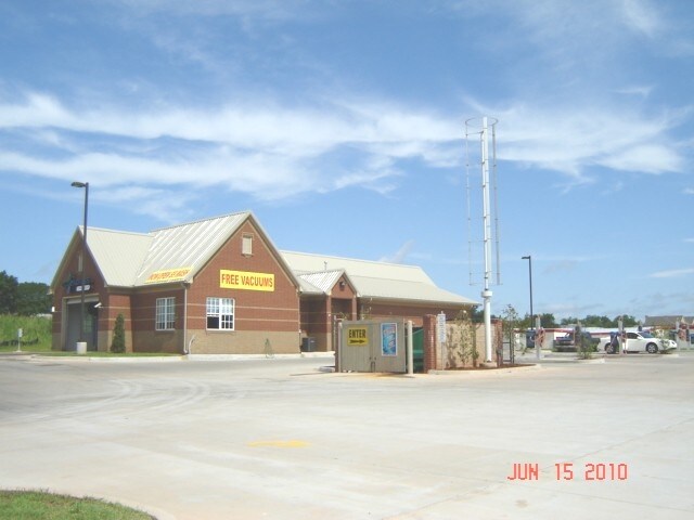
Property Record
1821 E Memorial Rd, Oklahoma City, OK 73131


NEARBY LISTINGS FOR SALE OR LEASE
Property Detail
1821 E Memorial Rd
182506125
Unpltd Pt Sec 11 13N 3W
Carwash
UNPLTD PT SE4 SEC 11 13N 3W BEG 620.98FT W & 50FT N OF SE/C SE4 TH W171FT N258.57FT E171FT S258.55FT TO BEG CONT 1.02ACRS MORE OR LESS
X
Oklahoma
40109C0176J
Oklahoma
2023
1.01 AC
2024
Edmond
108319
Oklahoma City
3,513 SF
Oklahoma City, OK
DEMOGRAPHICS near 1821 E Memorial Rd
1 Mile
3 Mile
5 Mile
2024 Total Population
7,425
46,500
150,277
2029 Population
7,562
47,299
153,365
Pop Growth 2024-2029
+ 1.85%
+ 1.72%
+ 2.05%
Average Age
36
38
38
2024 Total Households
3,088
18,604
62,338
HH Growth 2024-2029
+ 1.91%
+ 1.87%
+ 2.29%
Median Household Inc
$67,200
$74,076
$64,755
Avg Household Size
2.10
2.40
2.30
2024 Avg HH Vehicles
2.00
2.00
2.00
Median Home Value
$240,028
$229,819
$226,711
Median Year Built
1994
1986
1988
Nearby Places
Map Layers
Map Styles
 Street
 Aerial
- Restaurants
- Banks
- Shops
- Fitness
- Groceries
PUBLIC TRANSPORTATION
AIRPORT
Will Rogers World
DRIVE
WALK
Distance
Will Rogers World
34 min
20.6 mi
Nearby Properties
Address
Land Use
TOTAL SIZE
Lot Size
Zoning
Address
Land Use
TOTAL SIZE
Lot Size
Zoning
469,063 SF
71.44 AC
I-2
Address
Land Use
TOTAL SIZE
Lot Size
Zoning
268,796 SF
45.68 AC
I-2
Address
Land Use
TOTAL SIZE
Lot Size
Zoning
399,688 SF
80.57 AC
PUD
Address
Land Use
TOTAL SIZE
Lot Size
Zoning
470,139 SF
80.39 AC
I-2
Address
Land Use
TOTAL SIZE
Lot Size
Zoning
285,136 SF
13.04 AC
PUD
Address
Land Use
TOTAL SIZE
Lot Size
Zoning
225,492 SF
11.86 AC
R-4
Address
Land Use
TOTAL SIZE
Lot Size
Zoning
13,101 SF
1.22 AC
PUD
Address
Land Use
TOTAL SIZE
Lot Size
Zoning
43,489 SF
14.86 AC
PUD
Address
Land Use
TOTAL SIZE
Lot Size
Zoning
242,907 SF
I-2
Address
Land Use
TOTAL SIZE
Lot Size
Zoning
574,062 SF
57.69 AC
I-2
Address
Land Use
TOTAL SIZE
Lot Size
Zoning
242,196 SF
14.07 AC
Address
Land Use
TOTAL SIZE
Lot Size
Zoning
265,194 SF
13.67 AC
Address
Land Use
TOTAL SIZE
Lot Size
Zoning
234,208 SF
8.61 AC
PUD
Address
Land Use
TOTAL SIZE
Lot Size
Zoning
82,162 SF
6.13 AC
Address
Land Use
TOTAL SIZE
Lot Size
Zoning
221,364 SF
12.09 AC
Address
Land Use
TOTAL SIZE
Lot Size
Zoning
128,056 SF
5.84 AC
PUD
Address
Land Use
TOTAL SIZE
Lot Size
Zoning
167,664 SF
14.14 AC
Address
Land Use
TOTAL SIZE
Lot Size
Zoning
113,781 SF
14.06 AC
Address
Land Use
TOTAL SIZE
Lot Size
Zoning
570,717 SF
44 AC
I-2
Address
Land Use
TOTAL SIZE
Lot Size
Zoning
68,548 SF
6.90 AC
I-2
Address
Land Use
TOTAL SIZE
Lot Size
Zoning
59,307 SF
3.75 AC
PUD
Address
Land Use
TOTAL SIZE
Lot Size
Zoning
174,247 SF
9.41 AC
I-2
Address
Land Use
TOTAL SIZE
Lot Size
Zoning
53,067 SF
5.55 AC
PUD
Address
Land Use
TOTAL SIZE
Lot Size
Zoning
148,620 SF
15.78 AC
PUD
Address
Land Use
TOTAL SIZE
Lot Size
Zoning
51,176 SF
23.24 AC
PUD
Address
Land Use
TOTAL SIZE
Lot Size
Zoning
154,716 SF
15.12 AC
PUD
Address
Land Use
TOTAL SIZE
Lot Size
Zoning
132,226 SF
11.89 AC
Address
Land Use
TOTAL SIZE
Lot Size
Zoning
72,273 SF
6.58 AC
Address
Land Use
TOTAL SIZE
Lot Size
Zoning
151,796 SF
16.49 AC
PUD
Address
Land Use
TOTAL SIZE
Lot Size
Zoning
64,296 SF
8.43 AC
The World's #1 Commercial Real Estate Marketplace
Connect with us
© 2025 CoStar Group
The information above has been obtained from sources believed reliable. While we do not doubt its accuracy we have not verified it and make no guarantee, warranty or representation about it. It is your responsibility to independently confirm its accuracy and completeness. Any projections, opinions, assumptions, or estimates used are for example only and do not represent the current or future performance of the property. The value of this transaction to you depends on tax and other factors which should be evaluated by your tax, financial, and legal advisors. You and your advisors should conduct a careful, independent investigation of the property to determine to your satisfaction the suitability of the property for your needs.