Property Record
1821 Hooksett Rd, Hooksett, NH 03106
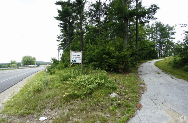
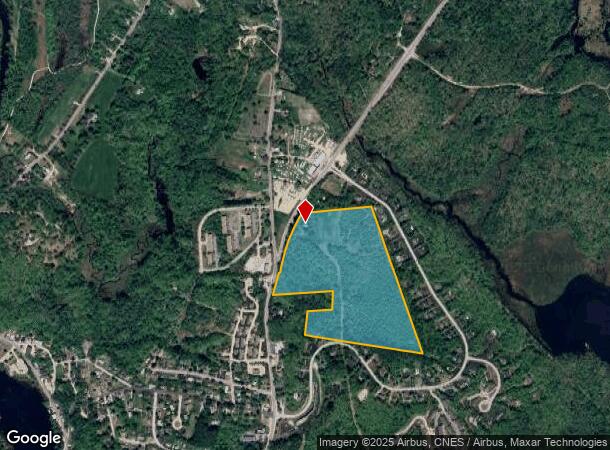
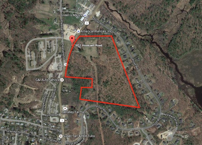
This Property Is For Sale
Property Detail
1821 Hooksett Rd
Sfr
Merrimack
X
New Hampshire
33013C0677F
40.07 AC
2024
Concord/New Hampshire North Area
2024
Other Market Areas
044200
Concord, NH
1,500 SF
HOOK-000006-000000-000010
NEARBY LISTINGS FOR SALE OR LEASE
DEMOGRAPHICS near 1821 Hooksett Rd
1 mile
3 mile
5 mile
2024 Total Population
1,749
13,573
31,946
2029 Population
1,852
14,341
33,639
Pop Growth 2024-2029
+ 5.89%
+ 5.66%
+ 5.30%
Average Age
42
42
42
2024 Total Households
682
5,733
12,898
HH Growth 2024-2029
+ 5.87%
+ 5.62%
+ 5.22%
Median Household Inc
$77,710
$77,096
$90,119
Avg Household Size
2.50
2.30
2.40
2024 Avg HH Vehicles
2.00
2.00
2.00
Median Home Value
$294,736
$272,547
$327,981
Median Year Built
1972
1977
1983
Nearby Places
Map Layers
Map Styles
 Street
 Aerial
Transit
 Traffic
 Biking
Places
Listings with unknown addresses are not visible on the map
- Restaurants
- Banks
- Shops
- Fitness
- Groceries
PUBLIC TRANSPORTATION
AIRPORT
Manchester Boston Regional
Drive
Walk
Distance
Manchester Boston Regional
31 min
16.9 mi
Freight Ports
Port of Boston
Drive
Walk
Distance
Port of Boston
95 min
60.8 mi
Nearby Properties
Address
Land Use
TOTAL SIZE
Lot Size
Zoning
Address
Land Use
TOTAL SIZE
Lot Size
Zoning
266,056 SF
22.11 AC
I2
Address
Land Use
TOTAL SIZE
Lot Size
Zoning
6,000 SF
66.58 AC
I2
Address
Land Use
TOTAL SIZE
Lot Size
Zoning
23,236 SF
26.66 AC
MUD2
Address
Land Use
TOTAL SIZE
Lot Size
Zoning
147,477 SF
41.81 AC
R-1A
Address
Land Use
TOTAL SIZE
Lot Size
Zoning
4,400 SF
76.15 AC
MUD4
Address
Land Use
TOTAL SIZE
Lot Size
Zoning
91,930 SF
59 AC
IND -
Address
Land Use
TOTAL SIZE
Lot Size
Zoning
114,272 SF
12.86 AC
CLI -
Address
Land Use
TOTAL SIZE
Lot Size
Zoning
13,686 SF
22.58 AC
HDR
Address
Land Use
TOTAL SIZE
Lot Size
Zoning
Address
Land Use
TOTAL SIZE
Lot Size
Zoning
183.12 AC
OSF -
Address
Land Use
TOTAL SIZE
Lot Size
Zoning
96,192 SF
17.42 AC
IND
Address
Land Use
TOTAL SIZE
Lot Size
Zoning
156,344 SF
19.90 AC
IND
Address
Land Use
TOTAL SIZE
Lot Size
Zoning
93,077 SF
35.96 AC
PZ
Address
Land Use
TOTAL SIZE
Lot Size
Zoning
9,662 SF
76.91 AC
COM
Address
Land Use
TOTAL SIZE
Lot Size
Zoning
28,124 SF
17.08 AC
I2
Address
Land Use
TOTAL SIZE
Lot Size
Zoning
80,844 SF
24.43 AC
MUD2
Address
Land Use
TOTAL SIZE
Lot Size
Zoning
16,461 SF
3.49 AC
Address
Land Use
TOTAL SIZE
Lot Size
Zoning
17,842 SF
3.74 AC
Address
Land Use
TOTAL SIZE
Lot Size
Zoning
76,586 SF
16.89 AC
PZ
Address
Land Use
TOTAL SIZE
Lot Size
Zoning
57,804 SF
2.75 AC
HDR
Address
Land Use
TOTAL SIZE
Lot Size
Zoning
10,200 SF
26.88 AC
I2
Address
Land Use
TOTAL SIZE
Lot Size
Zoning
Address
Land Use
TOTAL SIZE
Lot Size
Zoning
37,509 SF
19.80 AC
MDR
Address
Land Use
TOTAL SIZE
Lot Size
Zoning
141,218 SF
11.69 AC
IND
Address
Land Use
TOTAL SIZE
Lot Size
Zoning
23,466 SF
5.25 AC
Address
Land Use
TOTAL SIZE
Lot Size
Zoning
60.15 AC
COM
Address
Land Use
TOTAL SIZE
Lot Size
Zoning
23,780 SF
5.51 AC
Address
Land Use
TOTAL SIZE
Lot Size
Zoning
211 AC
I2
Address
Land Use
TOTAL SIZE
Lot Size
Zoning
4,950 SF
46.31 AC
IND
Address
Land Use
TOTAL SIZE
Lot Size
Zoning
10,506 SF
12.20 AC
IND -
The World's #1 Commercial Real Estate Marketplace
Connect with us
© 2026 CoStar Group
The information above has been obtained from sources believed reliable. While we do not doubt its accuracy we have not verified it and make no guarantee, warranty or representation about it. It is your responsibility to independently confirm its accuracy and completeness. Any projections, opinions, assumptions, or estimates used are for example only and do not represent the current or future performance of the property. The value of this transaction to you depends on tax and other factors which should be evaluated by your tax, financial, and legal advisors. You and your advisors should conduct a careful, independent investigation of the property to determine to your satisfaction the suitability of the property for your needs.