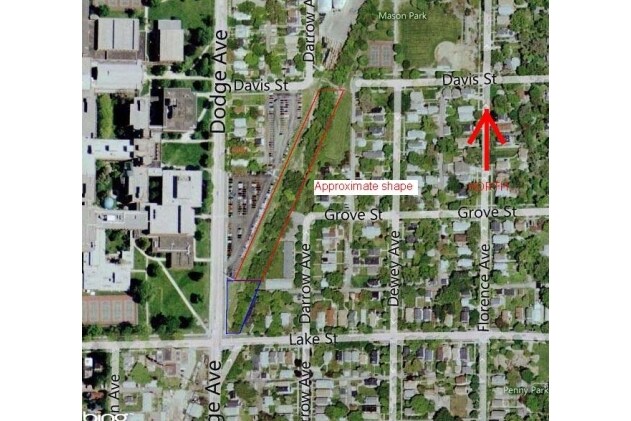
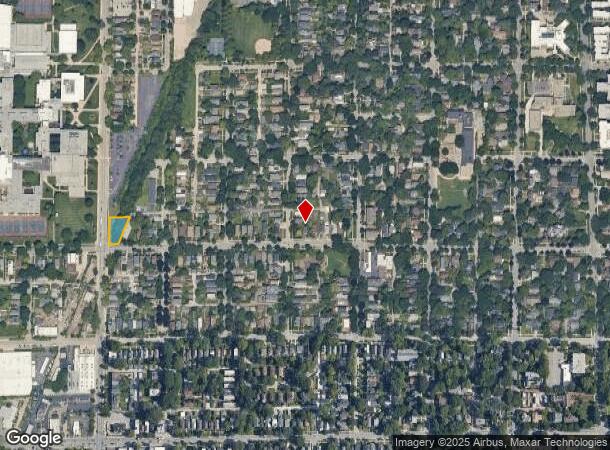
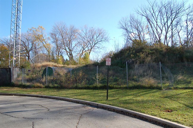
Property Record
1521 Lake St, Evanston, IL 60201
NEARBY LISTINGS FOR SALE OR LEASE
Property Detail
1521 Lake St
Chicago-Naperville-Elgin, IL-IN-WI
Brown & Culvers Add
10-13-413-013-0000
Cook
Vacantlandnec
Illinois
X
23-27
17031C0265J
0.31 AC
2023
Near North
2024
Chicago
809600
DEMOGRAPHICS near 1521 Lake St
1 Mile
3 Mile
5 Mile
2024 Total Population
31,807
216,848
454,147
2029 Population
30,873
211,304
441,421
Pop Growth 2024-2029
(2.94%)
(2.56%)
(2.80%)
Average Age
39
41
41
2024 Total Households
12,971
83,159
179,689
HH Growth 2024-2029
(2.81%)
(2.78%)
(3.04%)
Median Household Inc
$73,279
$79,008
$74,096
Avg Household Size
2.20
2.40
2.40
2024 Avg HH Vehicles
1.00
1.00
1.00
Median Home Value
$404,667
$400,349
$397,828
Median Year Built
1957
1953
1952
Nearby Places
Map Layers
Map Styles
 Street
 Aerial
- Restaurants
- Banks
- Shops
- Fitness
- Groceries
PUBLIC TRANSPORTATION
TRANSIT/SUBWAY
Davis Station (Purple Line - Chicago Transit Authority "L" Trains (The "L"))
DRIVE
WALK
Distance
Davis Station (Purple Line - Chicago Transit Authority "L" Trains (The "L"))
2 min
15 min
0.8 mi
Dempster Station (Purple Line - Chicago Transit Authority "L" Trains (The "L"))
DRIVE
WALK
Distance
Dempster Station (Purple Line - Chicago Transit Authority "L" Trains (The "L"))
3 min
17 min
0.9 mi
COMMUTER RAIL
Evanston Davis Street Station (Union Pacific North Line - Northeast Illinois Regional Commuter Railroad (Metra))
DRIVE
WALK
Distance
Evanston Davis Street Station (Union Pacific North Line - Northeast Illinois Regional Commuter Railroad (Metra))
2 min
15 min
0.8 mi
Evanston Main Street Station (Union Pacific North Line - Northeast Illinois Regional Commuter Railroad (Metra))
DRIVE
WALK
Distance
Evanston Main Street Station (Union Pacific North Line - Northeast Illinois Regional Commuter Railroad (Metra))
4 min
1.6 mi
AIRPORT
Chicago O'Hare International
DRIVE
WALK
Distance
Chicago O'Hare International
29 min
14.8 mi
Chicago Midway International
DRIVE
WALK
Distance
Chicago Midway International
39 min
24.9 mi
Freight Ports
Port Milwaukee
DRIVE
WALK
Distance
Port Milwaukee
91 min
73.7 mi
SALE & LEASE HISTORY
LISTING DATE
SALE/LEASE

Sep 24, 2016
For Sale
Sep 16, 2021
For Sale
Nov 26, 2018
For Sale
Nearby Properties
Address
Land Use
TOTAL SIZE
Lot Size
Zoning
Address
Land Use
TOTAL SIZE
Lot Size
Zoning
999,808 SF
50.13 AC
Address
Land Use
TOTAL SIZE
Lot Size
Zoning
180,397 SF
0.78 AC
Address
Land Use
TOTAL SIZE
Lot Size
Zoning
0.63 AC
Address
Land Use
TOTAL SIZE
Lot Size
Zoning
341,698 SF
0.64 AC
Address
Land Use
TOTAL SIZE
Lot Size
Zoning
165,067 SF
10.88 AC
Address
Land Use
TOTAL SIZE
Lot Size
Zoning
305,592 SF
27.35 AC
Address
Land Use
TOTAL SIZE
Lot Size
Zoning
82,139 SF
4.88 AC
Address
Land Use
TOTAL SIZE
Lot Size
Zoning
892,012 SF
37.29 AC
Address
Land Use
TOTAL SIZE
Lot Size
Zoning
2.10 AC
Address
Land Use
TOTAL SIZE
Lot Size
Zoning
218,982 SF
1.97 AC
Address
Land Use
TOTAL SIZE
Lot Size
Zoning
372,244 SF
7.12 AC
Address
Land Use
TOTAL SIZE
Lot Size
Zoning
303,960 SF
0.98 AC
Address
Land Use
TOTAL SIZE
Lot Size
Zoning
232,552 SF
5.78 AC
Address
Land Use
TOTAL SIZE
Lot Size
Zoning
429,949 SF
16.06 AC
Address
Land Use
TOTAL SIZE
Lot Size
Zoning
251,409 SF
16.33 AC
Address
Land Use
TOTAL SIZE
Lot Size
Zoning
176,115 SF
1.04 AC
Address
Land Use
TOTAL SIZE
Lot Size
Zoning
0.84 AC
Address
Land Use
TOTAL SIZE
Lot Size
Zoning
110,528 SF
3.05 AC
Address
Land Use
TOTAL SIZE
Lot Size
Zoning
1.67 AC
Address
Land Use
TOTAL SIZE
Lot Size
Zoning
163,981 SF
4 AC
Address
Land Use
TOTAL SIZE
Lot Size
Zoning
5.65 AC
Address
Land Use
TOTAL SIZE
Lot Size
Zoning
145,548 SF
0.80 AC
Address
Land Use
TOTAL SIZE
Lot Size
Zoning
243,781 SF
0.84 AC
Address
Land Use
TOTAL SIZE
Lot Size
Zoning
0.30 AC
Address
Land Use
TOTAL SIZE
Lot Size
Zoning
208,785 SF
0.61 AC
Address
Land Use
TOTAL SIZE
Lot Size
Zoning
Address
Land Use
TOTAL SIZE
Lot Size
Zoning
0.84 AC
Address
Land Use
TOTAL SIZE
Lot Size
Zoning
0.38 AC
Address
Land Use
TOTAL SIZE
Lot Size
Zoning
223,366 SF
0.65 AC
Address
Land Use
TOTAL SIZE
Lot Size
Zoning
70,792 SF
1.40 AC
PD 631
The World's #1 Commercial Real Estate Marketplace
Connect with us
© 2025 CoStar Group
The information above has been obtained from sources believed reliable. While we do not doubt its accuracy we have not verified it and make no guarantee, warranty or representation about it. It is your responsibility to independently confirm its accuracy and completeness. Any projections, opinions, assumptions, or estimates used are for example only and do not represent the current or future performance of the property. The value of this transaction to you depends on tax and other factors which should be evaluated by your tax, financial, and legal advisors. You and your advisors should conduct a careful, independent investigation of the property to determine to your satisfaction the suitability of the property for your needs.