Property Record
1821 N State Road 7, Margate, FL 33063
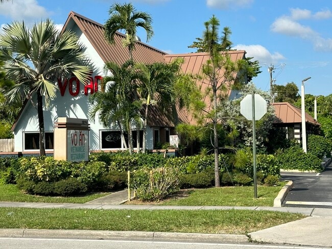


This Property Is For Sale
NEARBY LISTINGS FOR SALE OR LEASE
Property Detail
1821 N State Road 7
Fort Lauderdale-Pompano Beach-Deerfield Beach, FL
Ibec Neighborhood No 1 45-42 B
48-41-25-07-0661
IBEC NEIGHBORHOOD NO 1 45-42 B LOT 65 S 100 OF N 200 OF S 600
Restaurantbuilding
Broward
X
Florida
12099C1175F
65
2024
0.54 AC
2025
NW Broward/Coral Springs
020209
South Florida
3,082 SF
DEMOGRAPHICS near 1821 N State Road 7
1 Mile
3 Mile
5 Mile
2024 Total Population
16,870
166,306
382,909
2029 Population
16,794
165,845
380,480
Pop Growth 2024-2029
(0.45%)
(0.28%)
(0.63%)
Average Age
42
42
40
2024 Total Households
6,701
63,571
142,009
HH Growth 2024-2029
(0.97%)
(0.50%)
(0.94%)
Median Household Inc
$52,141
$61,139
$62,406
Avg Household Size
2.40
2.50
2.60
2024 Avg HH Vehicles
2.00
2.00
2.00
Median Home Value
$281,580
$269,447
$290,775
Median Year Built
1979
1981
1981
Nearby Places
Map Layers
Map Styles
 Street
 Aerial
- Restaurants
- Banks
- Shops
- Fitness
- Groceries
PUBLIC TRANSPORTATION
COMMUTER RAIL
Pompano Beach (Tri-County Commuter - South Florida Regional Transportation Authority (Tri-Rail))
DRIVE
WALK
Distance
Pompano Beach (Tri-County Commuter - South Florida Regional Transportation Authority (Tri-Rail))
11 min
5.2 mi
Cypress Creek (Tri-County Commuter - South Florida Regional Transportation Authority (Tri-Rail))
DRIVE
WALK
Distance
Cypress Creek (Tri-County Commuter - South Florida Regional Transportation Authority (Tri-Rail))
14 min
7.2 mi
AIRPORT
Fort Lauderdale/Hollywood International
DRIVE
WALK
Distance
Fort Lauderdale/Hollywood International
30 min
18.3 mi
Palm Beach International
DRIVE
WALK
Distance
Palm Beach International
50 min
36.9 mi
Miami International
DRIVE
WALK
Distance
Miami International
60 min
44.1 mi
Nearby Properties
Address
Land Use
TOTAL SIZE
Lot Size
Zoning
Address
Land Use
TOTAL SIZE
Lot Size
Zoning
425,379 SF
26.84 AC
RPUD
Address
Land Use
TOTAL SIZE
Lot Size
Zoning
32,538 SF
331.51 AC
P
Address
Land Use
TOTAL SIZE
Lot Size
Zoning
641,010 SF
29.99 AC
RM-20
Address
Land Use
TOTAL SIZE
Lot Size
Zoning
399,296 SF
20.23 AC
RM-40
Address
Land Use
TOTAL SIZE
Lot Size
Zoning
451,337 SF
33.01 AC
R-3A
Address
Land Use
TOTAL SIZE
Lot Size
Zoning
356,704 SF
11.84 AC
PCD
Address
Land Use
TOTAL SIZE
Lot Size
Zoning
294,865 SF
14.49 AC
PUD
Address
Land Use
TOTAL SIZE
Lot Size
Zoning
649,284 SF
62.54 AC
CF
Address
Land Use
TOTAL SIZE
Lot Size
Zoning
423,291 SF
25.66 AC
RM-10
Address
Land Use
TOTAL SIZE
Lot Size
Zoning
344,358 SF
23.27 AC
RM-20
Address
Land Use
TOTAL SIZE
Lot Size
Zoning
500,974 SF
16.20 AC
CF-1
Address
Land Use
TOTAL SIZE
Lot Size
Zoning
276,412 SF
10.40 AC
TOC-G
Address
Land Use
TOTAL SIZE
Lot Size
Zoning
278,336 SF
15.85 AC
RM-20
Address
Land Use
TOTAL SIZE
Lot Size
Zoning
548,682 SF
21.63 AC
CF
Address
Land Use
TOTAL SIZE
Lot Size
Zoning
295,885 SF
21.22 AC
PUD
Address
Land Use
TOTAL SIZE
Lot Size
Zoning
274,772 SF
22.37 AC
PUD
Address
Land Use
TOTAL SIZE
Lot Size
Zoning
238,895 SF
13.84 AC
TOC-CC
Address
Land Use
TOTAL SIZE
Lot Size
Zoning
325,343 SF
21.10 AC
PUD
Address
Land Use
TOTAL SIZE
Lot Size
Zoning
566,155 SF
38.24 AC
B-3
Address
Land Use
TOTAL SIZE
Lot Size
Zoning
216,533 SF
9.99 AC
RPUD
Address
Land Use
TOTAL SIZE
Lot Size
Zoning
384,131 SF
17.84 AC
PMDD
Address
Land Use
TOTAL SIZE
Lot Size
Zoning
311,836 SF
13.92 AC
RM-30
Address
Land Use
TOTAL SIZE
Lot Size
Zoning
291,908 SF
29.79 AC
B-3
Address
Land Use
TOTAL SIZE
Lot Size
Zoning
275,724 SF
26.67 AC
TOC-G
Address
Land Use
TOTAL SIZE
Lot Size
Zoning
269,508 SF
38.46 AC
A-1
Address
Land Use
TOTAL SIZE
Lot Size
Zoning
254,235 SF
25.40 AC
RM-10
Address
Land Use
TOTAL SIZE
Lot Size
Zoning
242,692 SF
17.25 AC
RM-20
Address
Land Use
TOTAL SIZE
Lot Size
Zoning
935,349 SF
20.20 AC
PMDD
Address
Land Use
TOTAL SIZE
Lot Size
Zoning
202,587 SF
11.01 AC
R-3A
Address
Land Use
TOTAL SIZE
Lot Size
Zoning
353,516 SF
33.96 AC
CF-E
The World's #1 Commercial Real Estate Marketplace
Connect with us
© 2026 CoStar Group
The information above has been obtained from sources believed reliable. While we do not doubt its accuracy we have not verified it and make no guarantee, warranty or representation about it. It is your responsibility to independently confirm its accuracy and completeness. Any projections, opinions, assumptions, or estimates used are for example only and do not represent the current or future performance of the property. The value of this transaction to you depends on tax and other factors which should be evaluated by your tax, financial, and legal advisors. You and your advisors should conduct a careful, independent investigation of the property to determine to your satisfaction the suitability of the property for your needs.