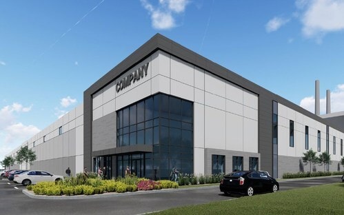
Property Record
Highway 62, Charlestown, IN 47111

NEARBY LISTINGS FOR SALE OR LEASE
Property Detail
Highway 62
10-18-09-500-106.000-004
GT 96--PT H-6 84.271 AC REMAIN
Countyproperty
Clark
X
Indiana
21185C0070D
84.27 AC
0
Outlying Clark County
2024
Louisville
050902
Louisville-Jefferson County, KY-IN
2,746 SF
DEMOGRAPHICS near Highway 62
1 Mile
3 Mile
5 Mile
2024 Total Population
486
11,849
26,983
2029 Population
501
12,753
28,826
Pop Growth 2024-2029
+ 3.09%
+ 7.63%
+ 6.83%
Average Age
38
40
40
2024 Total Households
180
4,454
9,667
HH Growth 2024-2029
+ 3.89%
+ 7.70%
+ 6.95%
Median Household Inc
$81,896
$78,375
$94,855
Avg Household Size
2.70
2.60
2.70
2024 Avg HH Vehicles
2.00
2.00
2.00
Median Home Value
$277,499
$252,828
$271,919
Median Year Built
1993
1992
1996
Nearby Places
- Restaurants
- Banks
- Shops
- Fitness
- Groceries
PUBLIC TRANSPORTATION
AIRPORT
Louisville Muhammad Ali International
DRIVE
WALK
Distance
Louisville Muhammad Ali International
35 min
21.3 mi
Freight Ports
Port of Toledo
DRIVE
WALK
Distance
Port of Toledo
357 min
308.0 mi
SALE & LEASE HISTORY
LISTING DATE
SALE/LEASE

Apr 26, 2023
For Lease
Nearby Properties
Address
Land Use
TOTAL SIZE
Lot Size
Zoning
Address
Land Use
TOTAL SIZE
Lot Size
Zoning
Address
Land Use
TOTAL SIZE
Lot Size
Zoning
Address
Land Use
TOTAL SIZE
Lot Size
Zoning
Address
Land Use
TOTAL SIZE
Lot Size
Zoning
460,600 SF
32.96 AC
Address
Land Use
TOTAL SIZE
Lot Size
Zoning
292,500 SF
22.36 AC
Address
Land Use
TOTAL SIZE
Lot Size
Zoning
312,078 SF
26.82 AC
Address
Land Use
TOTAL SIZE
Lot Size
Zoning
435,095 SF
22.66 AC
Address
Land Use
TOTAL SIZE
Lot Size
Zoning
18,128 SF
10.47 AC
Address
Land Use
TOTAL SIZE
Lot Size
Zoning
197,784 SF
11.09 AC
Address
Land Use
TOTAL SIZE
Lot Size
Zoning
15.99 AC
Address
Land Use
TOTAL SIZE
Lot Size
Zoning
65,707 SF
24.62 AC
Address
Land Use
TOTAL SIZE
Lot Size
Zoning
191,176 SF
15.41 AC
Address
Land Use
TOTAL SIZE
Lot Size
Zoning
1.78 AC
Address
Land Use
TOTAL SIZE
Lot Size
Zoning
61,200 SF
22.97 AC
Address
Land Use
TOTAL SIZE
Lot Size
Zoning
39,897 SF
54.99 AC
Address
Land Use
TOTAL SIZE
Lot Size
Zoning
3,312 SF
8.59 AC
Address
Land Use
TOTAL SIZE
Lot Size
Zoning
159,800 SF
19.93 AC
Address
Land Use
TOTAL SIZE
Lot Size
Zoning
18,128 SF
3.91 AC
Address
Land Use
TOTAL SIZE
Lot Size
Zoning
49,150 SF
1.07 AC
Address
Land Use
TOTAL SIZE
Lot Size
Zoning
61,012 SF
5.05 AC
Address
Land Use
TOTAL SIZE
Lot Size
Zoning
41,515 SF
5.49 AC
Address
Land Use
TOTAL SIZE
Lot Size
Zoning
140,489 SF
6 AC
Address
Land Use
TOTAL SIZE
Lot Size
Zoning
1,600 SF
2.50 AC
Address
Land Use
TOTAL SIZE
Lot Size
Zoning
26,810 SF
2.96 AC
Address
Land Use
TOTAL SIZE
Lot Size
Zoning
3,960 SF
Address
Land Use
TOTAL SIZE
Lot Size
Zoning
6,008 SF
6.20 AC
Address
Land Use
TOTAL SIZE
Lot Size
Zoning
14,656 SF
3.24 AC
Address
Land Use
TOTAL SIZE
Lot Size
Zoning
12,464 SF
2.50 AC
Address
Land Use
TOTAL SIZE
Lot Size
Zoning
7,200 SF
1.64 AC
Address
Land Use
TOTAL SIZE
Lot Size
Zoning
24,186 SF
0.73 AC
The World's #1 Commercial Real Estate Marketplace
Connect with us
© 2025 CoStar Group
The information above has been obtained from sources believed reliable. While we do not doubt its accuracy we have not verified it and make no guarantee, warranty or representation about it. It is your responsibility to independently confirm its accuracy and completeness. Any projections, opinions, assumptions, or estimates used are for example only and do not represent the current or future performance of the property. The value of this transaction to you depends on tax and other factors which should be evaluated by your tax, financial, and legal advisors. You and your advisors should conduct a careful, independent investigation of the property to determine to your satisfaction the suitability of the property for your needs.