Property Record
18210 Virgil H Goode Hwy, Rocky Mount, VA 24151
NEARBY LISTINGS FOR SALE OR LEASE
-
-
View all Rocky Mount listings for sale on LoopNet.com
Property Detail
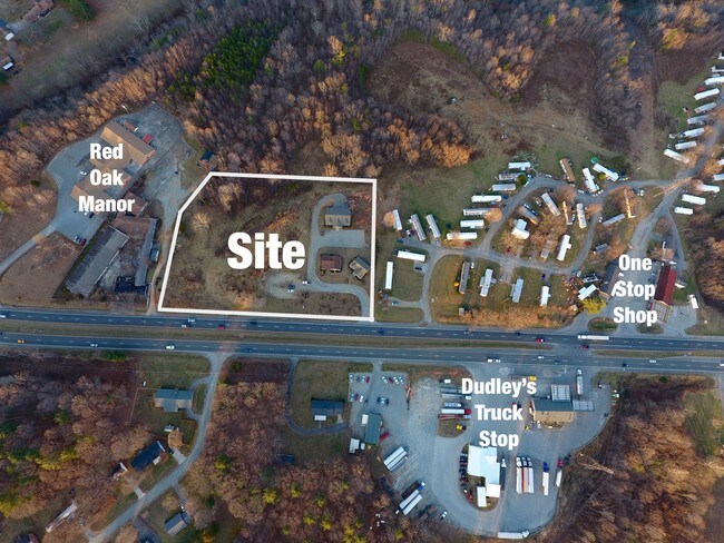
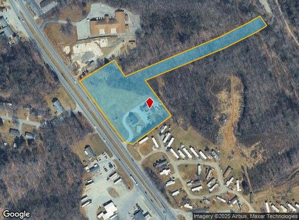
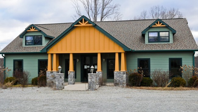
18210 Virgil H Goode Hwy
0440014900
New 220
Officebuilding
ON NEW 220
A
Franklin
51067C0195C
Virginia
2025
5.18 AC
2025
North Franklin County
020400
Roanoke
2,548 SF
Roanoke, VA
DEMOGRAPHICS near 18210 Virgil H Goode Hwy
1 Mile
3 Mile
5 Mile
2024 Total Population
455
4,536
13,268
2029 Population
456
4,544
13,328
Pop Growth 2024-2029
+ 0.22%
+ 0.18%
+ 0.45%
Average Age
43
42
42
2024 Total Households
196
1,940
5,564
HH Growth 2024-2029
0.00%
(0.05%)
+ 0.25%
Median Household Inc
$69,749
$60,542
$55,673
Avg Household Size
2.30
2.30
2.30
2024 Avg HH Vehicles
3.00
2.00
2.00
Median Home Value
$215,741
$197,094
$188,359
Median Year Built
1982
1981
1979
Nearby Places
- Restaurants
- Banks
- Shops
- Fitness
- Groceries
PUBLIC TRANSPORTATION
AIRPORT
Roanoke/Blacksburg Regional (Woodrum Field)
DRIVE
WALK
Distance
Roanoke/Blacksburg Regional (Woodrum Field)
36 min
26.4 mi
Freight Ports
Virginia Port Authority - Richmond
DRIVE
WALK
Distance
Virginia Port Authority - Richmond
232 min
167.6 mi
SALE & LEASE HISTORY
LISTING DATE
SALE/LEASE

Aug 25, 2017
For Sale
Nearby Properties
Address
Land Use
TOTAL SIZE
Lot Size
Zoning
Address
Land Use
TOTAL SIZE
Lot Size
Zoning
131,046 SF
32.45 AC
POS
Address
Land Use
TOTAL SIZE
Lot Size
Zoning
96,370 SF
32.42 AC
POS
Address
Land Use
TOTAL SIZE
Lot Size
Zoning
63,050 SF
15 AC
C1
Address
Land Use
TOTAL SIZE
Lot Size
Zoning
52,544 SF
13.35 AC
GB
Address
Land Use
TOTAL SIZE
Lot Size
Zoning
147,812 SF
35.07 AC
GB
Address
Land Use
TOTAL SIZE
Lot Size
Zoning
50,216 SF
7.91 AC
B2
Address
Land Use
TOTAL SIZE
Lot Size
Zoning
135,884 SF
35.66 AC
GB
Address
Land Use
TOTAL SIZE
Lot Size
Zoning
730,076 SF
55.36 AC
SM
Address
Land Use
TOTAL SIZE
Lot Size
Zoning
70,122 SF
15.97 AC
GB
Address
Land Use
TOTAL SIZE
Lot Size
Zoning
60,434 SF
12.67 AC
R1
Address
Land Use
TOTAL SIZE
Lot Size
Zoning
115,920 SF
7.62 AC
SM
Address
Land Use
TOTAL SIZE
Lot Size
Zoning
265,449 SF
12.25 AC
M2
Address
Land Use
TOTAL SIZE
Lot Size
Zoning
100,000 SF
10.51 AC
M1
Address
Land Use
TOTAL SIZE
Lot Size
Zoning
44,067 SF
15 AC
POS
Address
Land Use
TOTAL SIZE
Lot Size
Zoning
189,640 SF
17.98 AC
M1
Address
Land Use
TOTAL SIZE
Lot Size
Zoning
71,830 SF
17.41 AC
M2
Address
Land Use
TOTAL SIZE
Lot Size
Zoning
94,374 SF
25.06 AC
M1
Address
Land Use
TOTAL SIZE
Lot Size
Zoning
21,012 SF
8.60 AC
REP
Address
Land Use
TOTAL SIZE
Lot Size
Zoning
25,036 SF
1.70 AC
GB
Address
Land Use
TOTAL SIZE
Lot Size
Zoning
14,616 SF
1.38 AC
Address
Land Use
TOTAL SIZE
Lot Size
Zoning
6,760 SF
2.75 AC
SM
Address
Land Use
TOTAL SIZE
Lot Size
Zoning
28,595 SF
2.44 AC
C1
Address
Land Use
TOTAL SIZE
Lot Size
Zoning
37,560 SF
2.07 AC
GB
Address
Land Use
TOTAL SIZE
Lot Size
Zoning
18,750 SF
2.41 AC
PCD
Address
Land Use
TOTAL SIZE
Lot Size
Zoning
13,106 SF
2.31 AC
GB
Address
Land Use
TOTAL SIZE
Lot Size
Zoning
77,550 SF
9.37 AC
M1
Address
Land Use
TOTAL SIZE
Lot Size
Zoning
19,124 SF
2.87 AC
C1
Address
Land Use
TOTAL SIZE
Lot Size
Zoning
4,671 SF
1.30 AC
GB
Address
Land Use
TOTAL SIZE
Lot Size
Zoning
53,809 SF
6.67 AC
M1
Address
Land Use
TOTAL SIZE
Lot Size
Zoning
12,700 SF
1.97 AC
GB
The World's #1 Commercial Real Estate Marketplace
Connect with us
© 2025 CoStar Group
The information above has been obtained from sources believed reliable. While we do not doubt its accuracy we have not verified it and make no guarantee, warranty or representation about it. It is your responsibility to independently confirm its accuracy and completeness. Any projections, opinions, assumptions, or estimates used are for example only and do not represent the current or future performance of the property. The value of this transaction to you depends on tax and other factors which should be evaluated by your tax, financial, and legal advisors. You and your advisors should conduct a careful, independent investigation of the property to determine to your satisfaction the suitability of the property for your needs.