Property Record
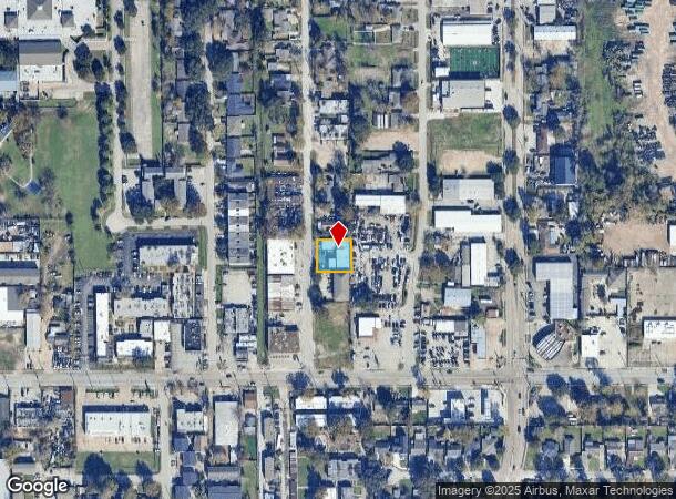
1824 Thonig Rd, Houston, TX 77055
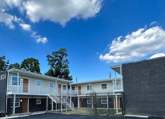
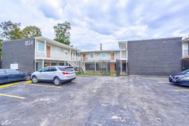
This Property Is For Sale
NEARBY LISTINGS FOR SALE OR LEASE
Property Detail
1824 Thonig Rd
0421300010216
Abst 269 J Flowers
Apartment
TR 52 THONIG TRACT ABST 269 J FLOWERS
X
Harris
48201C0665M
Texas
2024
0.25 AC
2025
Spring Branch East
520400
Houston
8,700 SF
Houston-Pasadena-The Woodlands, TX
DEMOGRAPHICS near 1824 Thonig Rd
1 Mile
3 Mile
5 Mile
2024 Total Population
18,619
134,285
411,023
2029 Population
19,317
138,883
425,750
Pop Growth 2024-2029
+ 3.75%
+ 3.42%
+ 3.58%
Average Age
37
37
38
2024 Total Households
6,937
52,793
176,682
HH Growth 2024-2029
+ 3.86%
+ 3.51%
+ 3.74%
Median Household Inc
$54,368
$65,429
$77,778
Avg Household Size
2.60
2.50
2.30
2024 Avg HH Vehicles
2.00
2.00
2.00
Median Home Value
$471,089
$414,497
$434,700
Median Year Built
1982
1977
1984
Nearby Places
Map Layers
Map Styles
 Street
 Aerial
- Restaurants
- Banks
- Shops
- Fitness
- Groceries
PUBLIC TRANSPORTATION
COMMUTER RAIL
Houston (Sunset Limited - Amtrak)
DRIVE
WALK
Distance
Houston (Sunset Limited - Amtrak)
15 min
8.9 mi
AIRPORT
William P Hobby
DRIVE
WALK
Distance
William P Hobby
36 min
21.2 mi
George Bush Intcntl/Houston
DRIVE
WALK
Distance
George Bush Intcntl/Houston
31 min
23.3 mi
Freight Ports
Port of Houston
DRIVE
WALK
Distance
Port of Houston
29 min
18.5 mi
Nearby Properties
Address
Land Use
TOTAL SIZE
Lot Size
Zoning
Address
Land Use
TOTAL SIZE
Lot Size
Zoning
402,886 SF
17.95 AC
Address
Land Use
TOTAL SIZE
Lot Size
Zoning
224,114 SF
4.24 AC
Address
Land Use
TOTAL SIZE
Lot Size
Zoning
714,049 SF
25.73 AC
Address
Land Use
TOTAL SIZE
Lot Size
Zoning
504,256 SF
6.09 AC
Address
Land Use
TOTAL SIZE
Lot Size
Zoning
366,386 SF
10.85 AC
Address
Land Use
TOTAL SIZE
Lot Size
Zoning
375,693 SF
9.16 AC
Address
Land Use
TOTAL SIZE
Lot Size
Zoning
605,420 SF
7.51 AC
Address
Land Use
TOTAL SIZE
Lot Size
Zoning
350,655 SF
16.76 AC
Address
Land Use
TOTAL SIZE
Lot Size
Zoning
279,934 SF
8 AC
Address
Land Use
TOTAL SIZE
Lot Size
Zoning
721,788 SF
10.14 AC
Address
Land Use
TOTAL SIZE
Lot Size
Zoning
211,190 SF
2.53 AC
Address
Land Use
TOTAL SIZE
Lot Size
Zoning
251,980 SF
2.55 AC
Address
Land Use
TOTAL SIZE
Lot Size
Zoning
292,292 SF
10.36 AC
Address
Land Use
TOTAL SIZE
Lot Size
Zoning
443,228 SF
3.15 AC
Address
Land Use
TOTAL SIZE
Lot Size
Zoning
478,524 SF
5.68 AC
Address
Land Use
TOTAL SIZE
Lot Size
Zoning
750,156 SF
22.95 AC
Address
Land Use
TOTAL SIZE
Lot Size
Zoning
363,503 SF
12.81 AC
Address
Land Use
TOTAL SIZE
Lot Size
Zoning
293,407 SF
9.19 AC
Address
Land Use
TOTAL SIZE
Lot Size
Zoning
378,225 SF
11.51 AC
Address
Land Use
TOTAL SIZE
Lot Size
Zoning
774,668 SF
7.12 AC
Address
Land Use
TOTAL SIZE
Lot Size
Zoning
377,639 SF
7.88 AC
Address
Land Use
TOTAL SIZE
Lot Size
Zoning
418,456 SF
5.72 AC
Address
Land Use
TOTAL SIZE
Lot Size
Zoning
247,490 SF
2 AC
Address
Land Use
TOTAL SIZE
Lot Size
Zoning
394,910 SF
15.04 AC
Address
Land Use
TOTAL SIZE
Lot Size
Zoning
185,068 SF
21.92 AC
Address
Land Use
TOTAL SIZE
Lot Size
Zoning
387,788 SF
17.95 AC
Address
Land Use
TOTAL SIZE
Lot Size
Zoning
229,369 SF
4 AC
Address
Land Use
TOTAL SIZE
Lot Size
Zoning
718,518 SF
2.04 AC
Address
Land Use
TOTAL SIZE
Lot Size
Zoning
304,557 SF
4.90 AC
Address
Land Use
TOTAL SIZE
Lot Size
Zoning
198,259 SF
19.57 AC
The World's #1 Commercial Real Estate Marketplace
Connect with us
© 2026 CoStar Group
The information above has been obtained from sources believed reliable. While we do not doubt its accuracy we have not verified it and make no guarantee, warranty or representation about it. It is your responsibility to independently confirm its accuracy and completeness. Any projections, opinions, assumptions, or estimates used are for example only and do not represent the current or future performance of the property. The value of this transaction to you depends on tax and other factors which should be evaluated by your tax, financial, and legal advisors. You and your advisors should conduct a careful, independent investigation of the property to determine to your satisfaction the suitability of the property for your needs.