Property Record
1825 E Warner Rd, Tempe, AZ 85284
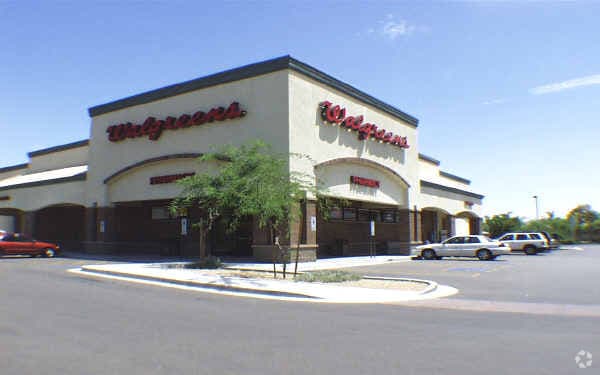


Property Detail
1825 E Warner Rd
301-63-793
ALTA MIRA PLAZA MCR 442-47
Storebuilding
Maricopa
C-C
Arizona
C and X Area of minimal flood hazard, usually depicted on FIRMs as above the 500-year flood level.
2
2025
1.87 AC
2025
Chandler
810100
Phoenix
13,949 SF
Phoenix-Mesa-Chandler, AZ
NEARBY LISTINGS FOR SALE OR LEASE
DEMOGRAPHICS near 1825 E Warner Rd
1 mile
3 mile
5 mile
2024 Total Population
9,937
113,811
324,569
2029 Population
10,139
116,740
334,084
Pop Growth 2024-2029
+ 2.03%
+ 2.57%
+ 2.93%
Average Age
43
40
39
2024 Total Households
3,798
45,291
131,271
HH Growth 2024-2029
+ 2.03%
+ 2.61%
+ 2.99%
Median Household Inc
$152,256
$111,671
$92,505
Avg Household Size
2.60
2.50
2.40
2024 Avg HH Vehicles
2.00
2.00
2.00
Median Home Value
$721,961
$494,029
$466,488
Median Year Built
1986
1986
1986
Nearby Places
Map Layers
Map Styles
 Street
 Aerial
Transit
 Traffic
 Biking
Places
Listings with unknown addresses are not visible on the map
- Restaurants
- Banks
- Shops
- Fitness
- Groceries
PUBLIC TRANSPORTATION
AIRPORT
Phoenix Sky Harbor International
Drive
Walk
Distance
Phoenix Sky Harbor International
22 min
14.8 mi
Phoenix-Mesa Gateway
Drive
Walk
Distance
Phoenix-Mesa Gateway
26 min
18.3 mi
Freight Ports
Port of San Diego
Drive
Walk
Distance
Port of San Diego
399 min
364.1 mi
SALE & LEASE HISTORY
LISTING DATE
SALE/LEASE

Jun 08, 2020
For Sale
Nearby Properties
Address
Land Use
TOTAL SIZE
Lot Size
Zoning
Address
Land Use
TOTAL SIZE
Lot Size
Zoning
136,458 SF
7.85 AC
PAD
Address
Land Use
TOTAL SIZE
Lot Size
Zoning
128,194 SF
8.58 AC
PAD
Address
Land Use
TOTAL SIZE
Lot Size
Zoning
1,149,733 SF
70.56 AC
PAD
Address
Land Use
TOTAL SIZE
Lot Size
Zoning
724,125 SF
39.23 AC
Address
Land Use
TOTAL SIZE
Lot Size
Zoning
14.98 AC
I-1
Address
Land Use
TOTAL SIZE
Lot Size
Zoning
774,482 SF
25.50 AC
PAD
Address
Land Use
TOTAL SIZE
Lot Size
Zoning
1,085,359 SF
74.95 AC
PAD
Address
Land Use
TOTAL SIZE
Lot Size
Zoning
860,343 SF
56.83 AC
I-1
Address
Land Use
TOTAL SIZE
Lot Size
Zoning
2.57 AC
Address
Land Use
TOTAL SIZE
Lot Size
Zoning
984,487 SF
37.54 AC
I-1
Address
Land Use
TOTAL SIZE
Lot Size
Zoning
15,066 SF
2.54 AC
PAD
Address
Land Use
TOTAL SIZE
Lot Size
Zoning
607,734 SF
17.89 AC
AG
Address
Land Use
TOTAL SIZE
Lot Size
Zoning
395,055 SF
8.33 AC
PAD
Address
Land Use
TOTAL SIZE
Lot Size
Zoning
269,504 SF
8.87 AC
I-1
Address
Land Use
TOTAL SIZE
Lot Size
Zoning
442,642 SF
35.15 AC
GID
Address
Land Use
TOTAL SIZE
Lot Size
Zoning
393,258 SF
49.79 AC
AG
Address
Land Use
TOTAL SIZE
Lot Size
Zoning
415,228 SF
19.48 AC
I-1
Address
Land Use
TOTAL SIZE
Lot Size
Zoning
177,897 SF
17.81 AC
AG
Address
Land Use
TOTAL SIZE
Lot Size
Zoning
403,326 SF
8.71 AC
PAD
Address
Land Use
TOTAL SIZE
Lot Size
Zoning
249,019 SF
23.96 AC
AG
Address
Land Use
TOTAL SIZE
Lot Size
Zoning
444,802 SF
4.17 AC
I-1
Address
Land Use
TOTAL SIZE
Lot Size
Zoning
175,866 SF
12.46 AC
AG
Address
Land Use
TOTAL SIZE
Lot Size
Zoning
22,149 SF
6.33 AC
PAD
Address
Land Use
TOTAL SIZE
Lot Size
Zoning
301,597 SF
10.79 AC
PAD
Address
Land Use
TOTAL SIZE
Lot Size
Zoning
244,900 SF
38.47 AC
PF
Address
Land Use
TOTAL SIZE
Lot Size
Zoning
379,460 SF
11.40 AC
PAD
Address
Land Use
TOTAL SIZE
Lot Size
Zoning
317,115 SF
36.47 AC
R-6
Address
Land Use
TOTAL SIZE
Lot Size
Zoning
313,144 SF
8.62 AC
PAD
Address
Land Use
TOTAL SIZE
Lot Size
Zoning
214,126 SF
11.42 AC
Address
Land Use
TOTAL SIZE
Lot Size
Zoning
453,582 SF
21.58 AC
PAD
The World's #1 Commercial Real Estate Marketplace
Connect with us
© 2026 CoStar Group
The information above has been obtained from sources believed reliable. While we do not doubt its accuracy we have not verified it and make no guarantee, warranty or representation about it. It is your responsibility to independently confirm its accuracy and completeness. Any projections, opinions, assumptions, or estimates used are for example only and do not represent the current or future performance of the property. The value of this transaction to you depends on tax and other factors which should be evaluated by your tax, financial, and legal advisors. You and your advisors should conduct a careful, independent investigation of the property to determine to your satisfaction the suitability of the property for your needs.