Property Record
1825 Horton Rd, Jackson, MI 49203
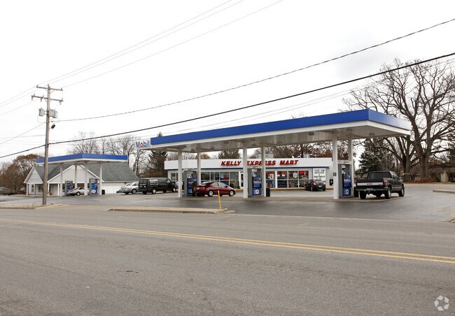

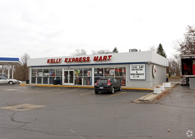
Property Detail
1825 Horton Rd
000-13-21-128-022-01
BEG AT N 1/4 POST OF SEC 21 TH S 01 DEG 26'00" W 783 FT TO CEN LN OF BADGLEY RD TH N 87 DEG 22'00" W 716.28 FT ALG SD CEN LN
Supermarket
Jackson
C-2
Michigan
B and X Area of moderate flood hazard, usually the area between the limits of the 100-year and 500-year floods.
0.99 AC
2024
Jackson County
2025
West Michigan
005202
Jackson, MI
2,502 SF
NEARBY LISTINGS FOR SALE OR LEASE
DEMOGRAPHICS near 1825 Horton Rd
1 mile
3 mile
5 mile
2025 Total Population
2,683
28,520
62,839
2030 Population
2,651
28,314
62,633
Pop Growth 2025-2030
(1.19%)
(0.72%)
(0.33%)
Average Age
44
42
40
2025 Total Households
1,071
11,566
25,773
HH Growth 2025-2030
(1.31%)
(0.82%)
(0.36%)
Median Household Inc
$80,229
$63,694
$52,598
Avg Household Size
2.40
2.30
2.30
2025 Avg HH Vehicles
2.00
2.00
2.00
Median Home Value
$243,275
$183,914
$158,365
Median Year Built
1962
1956
1954
Nearby Places
Map Layers
Map Styles
 Street
 Aerial
Layers
 Traffic
 Biking
Places
Listings with unknown addresses are not visible on the map
- Restaurants
- Banks
- Shops
- Fitness
- Groceries
PUBLIC TRANSPORTATION
COMMUTER RAIL
Drive
Walk
Distance
10 min
5.1 mi
Freight Ports
Drive
Walk
Distance
116 min
76.6 mi
Nearby Properties
Address
Land Use
TOTAL SIZE
Lot Size
Zoning
Address
Land Use
TOTAL SIZE
Lot Size
Zoning
110,011 SF
12.50 AC
Address
Land Use
TOTAL SIZE
Lot Size
Zoning
136,221 SF
8.04 AC
R-3
Address
Land Use
TOTAL SIZE
Lot Size
Zoning
136,221 SF
6.78 AC
R-3
Address
Land Use
TOTAL SIZE
Lot Size
Zoning
54,672 SF
5.93 AC
C-2
Address
Land Use
TOTAL SIZE
Lot Size
Zoning
23 AC
O-1
Address
Land Use
TOTAL SIZE
Lot Size
Zoning
45,510 SF
4.68 AC
PR1
Address
Land Use
TOTAL SIZE
Lot Size
Zoning
39,379 SF
7.34 AC
PR1
Address
Land Use
TOTAL SIZE
Lot Size
Zoning
6.60 AC
Address
Land Use
TOTAL SIZE
Lot Size
Zoning
25,852 SF
289 AC
AG1
Address
Land Use
TOTAL SIZE
Lot Size
Zoning
52,264 SF
3.53 AC
R-3
Address
Land Use
TOTAL SIZE
Lot Size
Zoning
122,698 SF
4.63 AC
I-2
Address
Land Use
TOTAL SIZE
Lot Size
Zoning
9.17 AC
RS2
Address
Land Use
TOTAL SIZE
Lot Size
Zoning
29,137 SF
1.87 AC
C-2
Address
Land Use
TOTAL SIZE
Lot Size
Zoning
34,968 SF
3.85 AC
C-1
Address
Land Use
TOTAL SIZE
Lot Size
Zoning
56,982 SF
4.55 AC
RM1
Address
Land Use
TOTAL SIZE
Lot Size
Zoning
40,170 SF
4.76 AC
C-2
Address
Land Use
TOTAL SIZE
Lot Size
Zoning
62,500 SF
10.85 AC
C-1
Address
Land Use
TOTAL SIZE
Lot Size
Zoning
24,754 SF
2.23 AC
O-1
Address
Land Use
TOTAL SIZE
Lot Size
Zoning
22,169 SF
4.97 AC
C-1
Address
Land Use
TOTAL SIZE
Lot Size
Zoning
22,135 SF
5.40 AC
PR1
Address
Land Use
TOTAL SIZE
Lot Size
Zoning
48,011 SF
5.37 AC
I-1
Address
Land Use
TOTAL SIZE
Lot Size
Zoning
3,426 SF
4.38 AC
C-2
Address
Land Use
TOTAL SIZE
Lot Size
Zoning
12,208 SF
2.75 AC
O-1
Address
Land Use
TOTAL SIZE
Lot Size
Zoning
60,188 SF
10 AC
I-1
Address
Land Use
TOTAL SIZE
Lot Size
Zoning
54,850 SF
9.10 AC
C-2
Address
Land Use
TOTAL SIZE
Lot Size
Zoning
18,890 SF
2.12 AC
O-1
Address
Land Use
TOTAL SIZE
Lot Size
Zoning
30,832 SF
3.48 AC
I-1
Address
Land Use
TOTAL SIZE
Lot Size
Zoning
6,164 SF
2.50 AC
O-1
Address
Land Use
TOTAL SIZE
Lot Size
Zoning
10,489 SF
1.69 AC
Address
Land Use
TOTAL SIZE
Lot Size
Zoning
47,500 SF
2.29 AC
I-2
The World's #1 Commercial Real Estate Marketplace
Connect with us
© 2026 CoStar Group
The information above has been obtained from sources believed reliable. While we do not doubt its accuracy we have not verified it and make no guarantee, warranty or representation about it. It is your responsibility to independently confirm its accuracy and completeness. Any projections, opinions, assumptions, or estimates used are for example only and do not represent the current or future performance of the property. The value of this transaction to you depends on tax and other factors which should be evaluated by your tax, financial, and legal advisors. You and your advisors should conduct a careful, independent investigation of the property to determine to your satisfaction the suitability of the property for your needs.