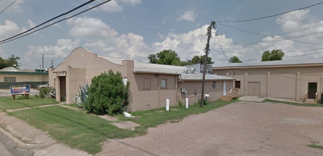
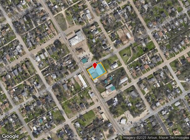
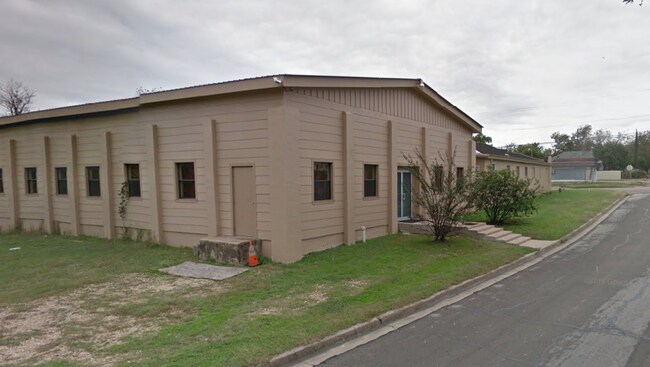
Property Record
1825 N 18Th St, Waco, TX 76707
NEARBY LISTINGS FOR SALE OR LEASE
-
-
View all Waco listings for sale on LoopNet.com
Property Detail
1825 N 18Th St
Waco, TX
University Hts
48-042400-069701-3
UNIVERSITY HTS LOT 8B BLOCK 60 ACRES .48
Commercialnec
Mclennan
X
Texas
48309C0366D
8b
2024
0.48 AC
2025
Downtown Waco
001100
Other Market Areas
9,742 SF
DEMOGRAPHICS near 1825 N 18Th St
1 mile
3 mile
5 mile
2024 Total Population
16,063
86,627
135,876
2029 Population
17,118
92,298
144,781
Pop Growth 2024-2029
+ 6.57%
+ 6.55%
+ 6.55%
Average Age
34
34
35
2024 Total Households
5,333
32,199
51,276
HH Growth 2024-2029
+ 6.71%
+ 7.02%
+ 6.90%
Median Household Inc
$37,287
$38,250
$42,374
Avg Household Size
2.90
2.40
2.40
2024 Avg HH Vehicles
2.00
2.00
2.00
Median Home Value
$82,874
$133,648
$143,328
Median Year Built
1956
1969
1972
Nearby Places
Map Layers
Map Styles
 Street
 Aerial
Transit
 Traffic
 Biking
Places
Listings with unknown addresses are not visible on the map
- Restaurants
- Banks
- Shops
- Fitness
- Groceries
PUBLIC TRANSPORTATION
AIRPORT
Waco Regional
Drive
Walk
Distance
Waco Regional
15 min
6.7 mi
SALE & LEASE HISTORY
LISTING DATE
SALE/LEASE

Jul 18, 2017
For Sale
Jan 17, 2018
For Sale
Nearby Properties
Address
Land Use
TOTAL SIZE
Lot Size
Zoning
Address
Land Use
TOTAL SIZE
Lot Size
Zoning
93.17 AC
2007 TIF
Address
Land Use
TOTAL SIZE
Lot Size
Zoning
549,274 SF
34.05 AC
O2
Address
Land Use
TOTAL SIZE
Lot Size
Zoning
120,623 SF
55.15 AC
2007 TIF
Address
Land Use
TOTAL SIZE
Lot Size
Zoning
560,620 SF
3.70 AC
O2
Address
Land Use
TOTAL SIZE
Lot Size
Zoning
576,501 SF
4.21 AC
Address
Land Use
TOTAL SIZE
Lot Size
Zoning
452,498 SF
39.43 AC
C-2
Address
Land Use
TOTAL SIZE
Lot Size
Zoning
394,674 SF
21.31 AC
O2
Address
Land Use
TOTAL SIZE
Lot Size
Zoning
27.28 AC
C
Address
Land Use
TOTAL SIZE
Lot Size
Zoning
399,747 SF
2.86 AC
C-3,C
Address
Land Use
TOTAL SIZE
Lot Size
Zoning
24.75 AC
O2
Address
Land Use
TOTAL SIZE
Lot Size
Zoning
213,814 SF
7.05 AC
2007 TIF
Address
Land Use
TOTAL SIZE
Lot Size
Zoning
69,809 SF
8.12 AC
2007 TIF
Address
Land Use
TOTAL SIZE
Lot Size
Zoning
126,592 SF
5.05 AC
2007 TIF
Address
Land Use
TOTAL SIZE
Lot Size
Zoning
188,746 SF
1.14 AC
O2
Address
Land Use
TOTAL SIZE
Lot Size
Zoning
188,465 SF
5.85 AC
2007 TIF
Address
Land Use
TOTAL SIZE
Lot Size
Zoning
Address
Land Use
TOTAL SIZE
Lot Size
Zoning
193,780 SF
14.12 AC
C
Address
Land Use
TOTAL SIZE
Lot Size
Zoning
214,351 SF
19.37 AC
R3B
Address
Land Use
TOTAL SIZE
Lot Size
Zoning
107,925 SF
2.20 AC
2007TIF
Address
Land Use
TOTAL SIZE
Lot Size
Zoning
16.78 AC
2007 TIF
Address
Land Use
TOTAL SIZE
Lot Size
Zoning
77,089 SF
5.09 AC
O2
Address
Land Use
TOTAL SIZE
Lot Size
Zoning
155,900 SF
2.85 AC
O2
Address
Land Use
TOTAL SIZE
Lot Size
Zoning
186,924 SF
9.14 AC
O-2
Address
Land Use
TOTAL SIZE
Lot Size
Zoning
19,209 SF
149.75 AC
O2
Address
Land Use
TOTAL SIZE
Lot Size
Zoning
142,734 SF
18.95 AC
R1B
Address
Land Use
TOTAL SIZE
Lot Size
Zoning
206,113 SF
7.33 AC
2007TIF
Address
Land Use
TOTAL SIZE
Lot Size
Zoning
189,996 SF
13.98 AC
O2
Address
Land Use
TOTAL SIZE
Lot Size
Zoning
225,762 SF
29.30 AC
C3
Address
Land Use
TOTAL SIZE
Lot Size
Zoning
167,206 SF
11.22 AC
R-3C
Address
Land Use
TOTAL SIZE
Lot Size
Zoning
238,580 SF
12.25 AC
R-3E
The World's #1 Commercial Real Estate Marketplace
Connect with us
© 2026 CoStar Group
The information above has been obtained from sources believed reliable. While we do not doubt its accuracy we have not verified it and make no guarantee, warranty or representation about it. It is your responsibility to independently confirm its accuracy and completeness. Any projections, opinions, assumptions, or estimates used are for example only and do not represent the current or future performance of the property. The value of this transaction to you depends on tax and other factors which should be evaluated by your tax, financial, and legal advisors. You and your advisors should conduct a careful, independent investigation of the property to determine to your satisfaction the suitability of the property for your needs.