Property Record
18255 N 83Rd Ave, Glendale, AZ 85308
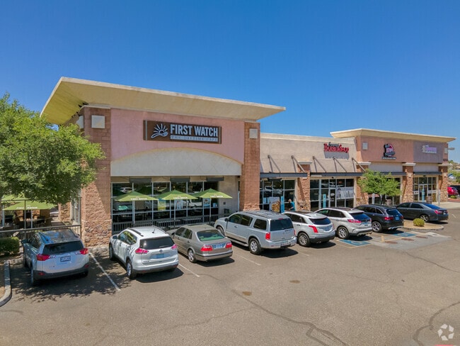

Property Detail
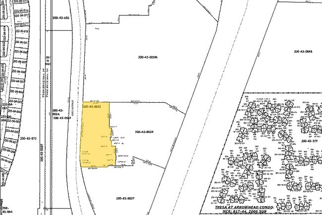
18255 N 83Rd Ave
200-43-003Z
TH PT NW4 SEC 35 DAF COM NW COR PROP DESC P/F 04-307440 TH E 197.19F TH S 192.53F TH E 17F TH S 68.11F TH W 10F TH S 24.39F TH E 10F TH S 43F TH E 30F TH S 63.30F TH E 3F TH S 39.70F TH W 3F TH S 43F TH W 57.89F TH S 9.51F TH W 200.90F TO ELY R/W LN
Storebuilding
Maricopa
PAD
Arizona
C and X Area of minimal flood hazard, usually depicted on FIRMs as above the 500-year flood level.
2.54 AC
2025
Ctrl Peoria/Arrowhead
2025
Phoenix
617700
Phoenix-Mesa-Chandler, AZ
17,160 SF
NEARBY LISTINGS FOR SALE OR LEASE
DEMOGRAPHICS near 18255 N 83Rd Ave
1 mile
3 mile
5 mile
2025 Total Population
11,983
113,500
273,524
2030 Population
12,429
117,587
283,310
Pop Growth 2025-2030
+ 3.72%
+ 3.60%
+ 3.58%
Average Age
41
47
45
2025 Total Households
5,124
47,691
110,989
HH Growth 2025-2030
+ 3.79%
+ 3.78%
+ 3.73%
Median Household Inc
$74,467
$87,416
$83,272
Avg Household Size
2.20
2.30
2.40
2025 Avg HH Vehicles
2.00
2.00
2.00
Median Home Value
$444,219
$443,346
$420,748
Median Year Built
1994
1992
1990
Nearby Places
Map Layers
Map Styles
 Street
 Aerial
Layers
 Traffic
 Biking
Places
Listings with unknown addresses are not visible on the map
- Restaurants
- Banks
- Shops
- Fitness
- Groceries
PUBLIC TRANSPORTATION
AIRPORT
Phoenix Sky Harbor International
Drive
Walk
Distance
Phoenix Sky Harbor International
41 min
31.4 mi
Freight Ports
Port of San Diego
Drive
Walk
Distance
Port of San Diego
398 min
357.3 mi
SALE & LEASE HISTORY
LISTING DATE
SALE/LEASE

Sep 25, 2016
For Lease
May 01, 2017
For Lease
Jan 19, 2022
For Lease
Apr 11, 2025
For Lease
Nearby Properties
Address
Land Use
TOTAL SIZE
Lot Size
Zoning
Address
Land Use
TOTAL SIZE
Lot Size
Zoning
81,100 SF
9.48 AC
PAD
Address
Land Use
TOTAL SIZE
Lot Size
Zoning
45,900 SF
11.09 AC
PAD
Address
Land Use
TOTAL SIZE
Lot Size
Zoning
7,916 SF
5.26 AC
C-C
Address
Land Use
TOTAL SIZE
Lot Size
Zoning
4,500 SF
13.50 AC
PAD
Address
Land Use
TOTAL SIZE
Lot Size
Zoning
284,223 SF
10.02 AC
C-C
Address
Land Use
TOTAL SIZE
Lot Size
Zoning
708,928 SF
44.86 AC
Address
Land Use
TOTAL SIZE
Lot Size
Zoning
238,942 SF
36.87 AC
R1-8
Address
Land Use
TOTAL SIZE
Lot Size
Zoning
19.95 AC
AG
Address
Land Use
TOTAL SIZE
Lot Size
Zoning
235,399 SF
41.79 AC
M-M
Address
Land Use
TOTAL SIZE
Lot Size
Zoning
399,561 SF
16.30 AC
Address
Land Use
TOTAL SIZE
Lot Size
Zoning
226,169 SF
20.48 AC
Address
Land Use
TOTAL SIZE
Lot Size
Zoning
348,803 SF
15.91 AC
PAD
Address
Land Use
TOTAL SIZE
Lot Size
Zoning
353,859 SF
11.71 AC
PAD
Address
Land Use
TOTAL SIZE
Lot Size
Zoning
133,377 SF
17.52 AC
PAD
Address
Land Use
TOTAL SIZE
Lot Size
Zoning
280,356 SF
12.73 AC
PAD
Address
Land Use
TOTAL SIZE
Lot Size
Zoning
219,122 SF
33 AC
R-6
Address
Land Use
TOTAL SIZE
Lot Size
Zoning
440,494 SF
26.25 AC
PAD
Address
Land Use
TOTAL SIZE
Lot Size
Zoning
392,885 SF
17.67 AC
M-H
Address
Land Use
TOTAL SIZE
Lot Size
Zoning
126,781 SF
10.06 AC
C-C
Address
Land Use
TOTAL SIZE
Lot Size
Zoning
344,908 SF
20.69 AC
C-C
Address
Land Use
TOTAL SIZE
Lot Size
Zoning
375,604 SF
6.31 AC
M-M
Address
Land Use
TOTAL SIZE
Lot Size
Zoning
126,814 SF
31.56 AC
R17
Address
Land Use
TOTAL SIZE
Lot Size
Zoning
284,715 SF
7.15 AC
M-M
Address
Land Use
TOTAL SIZE
Lot Size
Zoning
245,400 SF
22.90 AC
PAD
Address
Land Use
TOTAL SIZE
Lot Size
Zoning
150,002 SF
10.91 AC
C-C
Address
Land Use
TOTAL SIZE
Lot Size
Zoning
112,300 SF
13.72 AC
PAD
Address
Land Use
TOTAL SIZE
Lot Size
Zoning
283,107 SF
14.60 AC
M-M
Address
Land Use
TOTAL SIZE
Lot Size
Zoning
96,045 SF
13.69 AC
PAD
Address
Land Use
TOTAL SIZE
Lot Size
Zoning
319,723 SF
10.79 AC
PAD
Address
Land Use
TOTAL SIZE
Lot Size
Zoning
311,614 SF
19.03 AC
PAD
The World's #1 Commercial Real Estate Marketplace
Connect with us
© 2026 CoStar Group
The information above has been obtained from sources believed reliable. While we do not doubt its accuracy we have not verified it and make no guarantee, warranty or representation about it. It is your responsibility to independently confirm its accuracy and completeness. Any projections, opinions, assumptions, or estimates used are for example only and do not represent the current or future performance of the property. The value of this transaction to you depends on tax and other factors which should be evaluated by your tax, financial, and legal advisors. You and your advisors should conduct a careful, independent investigation of the property to determine to your satisfaction the suitability of the property for your needs.