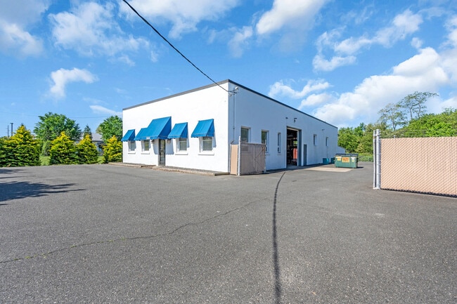
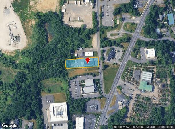
Property Record
1829 Old Mill Rd, Belmar, NJ 07719
NEARBY LISTINGS FOR SALE OR LEASE
Property Detail
1829 Old Mill Rd
52-00270-0000-00072
Monmouth
Commercialnec
New Jersey
X
72
34025C0341G
0.79 AC
2024
Southern Monmouth
2025
Northern New Jersey
808501
New York-Jersey City-White Plains, NY-NJ
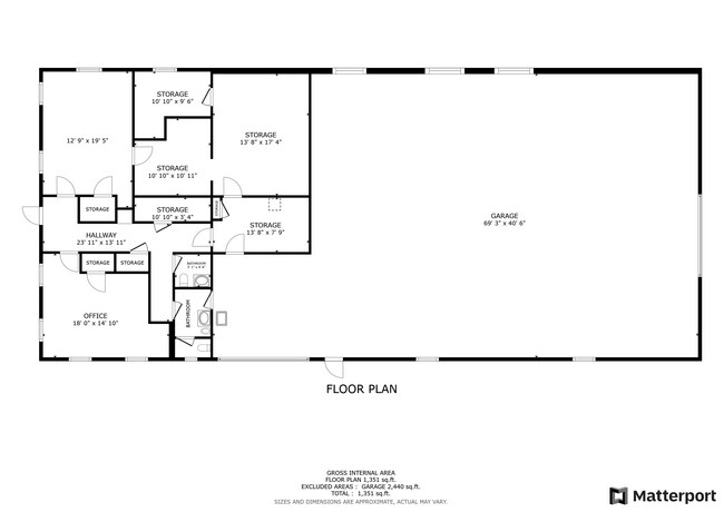
4,085 SF
DEMOGRAPHICS near 1829 Old Mill Rd
1 Mile
3 Mile
5 Mile
2024 Total Population
9,457
57,259
128,399
2029 Population
9,643
58,921
132,262
Pop Growth 2024-2029
+ 1.97%
+ 2.90%
+ 3.01%
Average Age
46
46
44
2024 Total Households
4,170
24,384
54,234
HH Growth 2024-2029
+ 1.80%
+ 2.91%
+ 3.15%
Median Household Inc
$105,197
$112,225
$102,178
Avg Household Size
2.20
2.30
2.30
2024 Avg HH Vehicles
2.00
2.00
2.00
Median Home Value
$601,868
$672,690
$597,345
Median Year Built
1972
1966
1966
Nearby Places
- Restaurants
- Banks
- Shops
- Fitness
- Groceries
PUBLIC TRANSPORTATION
COMMUTER RAIL
Spring Lake (North Jersey Coast Line - NJ Transit Commuter Rail (NJ Transit))
DRIVE
WALK
Distance
Spring Lake (North Jersey Coast Line - NJ Transit Commuter Rail (NJ Transit))
4 min
1.9 mi
Belmar (North Jersey Coast Line - NJ Transit Commuter Rail (NJ Transit))
DRIVE
WALK
Distance
Belmar (North Jersey Coast Line - NJ Transit Commuter Rail (NJ Transit))
3 min
2.3 mi
Freight Ports
New York Container Terminal
DRIVE
WALK
Distance
New York Container Terminal
61 min
46.3 mi
SALE & LEASE HISTORY
LISTING DATE
SALE/LEASE

May 22, 2025
For Sale
Nearby Properties
Address
Land Use
TOTAL SIZE
Lot Size
Zoning
Address
Land Use
TOTAL SIZE
Lot Size
Zoning
22,660 SF
164.35 AC
4
Address
Land Use
TOTAL SIZE
Lot Size
Zoning
2,596 SF
54.13 AC
SF10
Address
Land Use
TOTAL SIZE
Lot Size
Zoning
5,776 SF
25.50 AC
PB
Address
Land Use
TOTAL SIZE
Lot Size
Zoning
1,846 SF
23.23 AC
R-2
Address
Land Use
TOTAL SIZE
Lot Size
Zoning
23,868 SF
137.35 AC
R-1
Address
Land Use
TOTAL SIZE
Lot Size
Zoning
4,078 SF
0.01 AC
3
Address
Land Use
TOTAL SIZE
Lot Size
Zoning
3.46 AC
3
Address
Land Use
TOTAL SIZE
Lot Size
Zoning
190,893 SF
36.69 AC
POS
Address
Land Use
TOTAL SIZE
Lot Size
Zoning
17.66 AC
1E
Address
Land Use
TOTAL SIZE
Lot Size
Zoning
49,657 SF
11.22 AC
HB80
Address
Land Use
TOTAL SIZE
Lot Size
Zoning
20,959 SF
3.10 AC
R-1
Address
Land Use
TOTAL SIZE
Lot Size
Zoning
3.44 AC
R-2
Address
Land Use
TOTAL SIZE
Lot Size
Zoning
3,094 SF
277.60 AC
C
Address
Land Use
TOTAL SIZE
Lot Size
Zoning
7.79 AC
MLCC
Address
Land Use
TOTAL SIZE
Lot Size
Zoning
254,714 SF
3.40 AC
WPRA
Address
Land Use
TOTAL SIZE
Lot Size
Zoning
9.30 AC
SF05
Address
Land Use
TOTAL SIZE
Lot Size
Zoning
3.44 AC
SF05
Address
Land Use
TOTAL SIZE
Lot Size
Zoning
84,297 SF
42.37 AC
CR40
Address
Land Use
TOTAL SIZE
Lot Size
Zoning
145,918 SF
20.31 AC
OR-5
Address
Land Use
TOTAL SIZE
Lot Size
Zoning
8.82 AC
R2
Address
Land Use
TOTAL SIZE
Lot Size
Zoning
49,170 SF
8.38 AC
HB80
Address
Land Use
TOTAL SIZE
Lot Size
Zoning
45,236 SF
48.30 AC
POS
Address
Land Use
TOTAL SIZE
Lot Size
Zoning
27,328 SF
6.79 AC
HB12
Address
Land Use
TOTAL SIZE
Lot Size
Zoning
26.05 AC
SF10
Address
Land Use
TOTAL SIZE
Lot Size
Zoning
0.86 AC
R-1
Address
Land Use
TOTAL SIZE
Lot Size
Zoning
7.39 AC
R2
Address
Land Use
TOTAL SIZE
Lot Size
Zoning
8.76 AC
R1
Address
Land Use
TOTAL SIZE
Lot Size
Zoning
86,051 SF
9.41 AC
HB12
Address
Land Use
TOTAL SIZE
Lot Size
Zoning
6.43 AC
SF05
Address
Land Use
TOTAL SIZE
Lot Size
Zoning
115,960 SF
17.93 AC
OR-5
The World's #1 Commercial Real Estate Marketplace
Connect with us
© 2025 CoStar Group
The information above has been obtained from sources believed reliable. While we do not doubt its accuracy we have not verified it and make no guarantee, warranty or representation about it. It is your responsibility to independently confirm its accuracy and completeness. Any projections, opinions, assumptions, or estimates used are for example only and do not represent the current or future performance of the property. The value of this transaction to you depends on tax and other factors which should be evaluated by your tax, financial, and legal advisors. You and your advisors should conduct a careful, independent investigation of the property to determine to your satisfaction the suitability of the property for your needs.