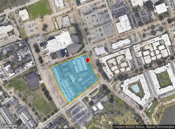
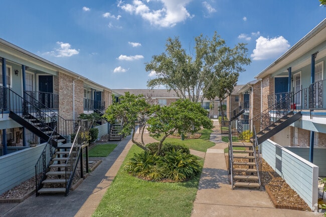
Property Record
18290 Upper Bay Rd, Houston, TX 77058

NEARBY LISTINGS FOR SALE OR LEASE
Property Detail
18290 Upper Bay Rd
0402110010048
Abst 13 S Deel
Apartment
TRS 1D & 1L ABST 13 S DEEL
AE
Harris
48167C0037G
Texas
2024
4.51 AC
2025
Nassau Bay
341204
Houston
116,098 SF
Houston-Pasadena-The Woodlands, TX
DEMOGRAPHICS near 18290 Upper Bay Rd
1 mile
3 mile
5 mile
2024 Total Population
8,883
69,839
184,998
2029 Population
9,117
71,959
189,920
Pop Growth 2024-2029
+ 2.63%
+ 3.04%
+ 2.66%
Average Age
39
39
39
2024 Total Households
4,226
30,142
74,549
HH Growth 2024-2029
+ 2.60%
+ 3.03%
+ 2.72%
Median Household Inc
$54,525
$72,188
$88,913
Avg Household Size
2.10
2.30
2.40
2024 Avg HH Vehicles
1.00
2.00
2.00
Median Home Value
$341,435
$276,339
$281,472
Median Year Built
1976
1985
1988
Nearby Places
Map Layers
Map Styles
 Street
 Aerial
Transit
 Traffic
 Biking
Places
Listings with unknown addresses are not visible on the map
- Restaurants
- Banks
- Shops
- Fitness
- Groceries
PUBLIC TRANSPORTATION
AIRPORT
William P Hobby
Drive
Walk
Distance
William P Hobby
30 min
16.3 mi
Freight Ports
Port of Houston
Drive
Walk
Distance
Port of Houston
34 min
22.8 mi
Nearby Properties
Address
Land Use
TOTAL SIZE
Lot Size
Zoning
Address
Land Use
TOTAL SIZE
Lot Size
Zoning
544,605 SF
27.49 AC
Address
Land Use
TOTAL SIZE
Lot Size
Zoning
538,570 SF
16.15 AC
Address
Land Use
TOTAL SIZE
Lot Size
Zoning
645,535 SF
4.40 AC
Address
Land Use
TOTAL SIZE
Lot Size
Zoning
780,870 SF
22.72 AC
Address
Land Use
TOTAL SIZE
Lot Size
Zoning
335,717 SF
21.15 AC
Address
Land Use
TOTAL SIZE
Lot Size
Zoning
502,791 SF
123.05 AC
Address
Land Use
TOTAL SIZE
Lot Size
Zoning
218,198 SF
7.27 AC
Address
Land Use
TOTAL SIZE
Lot Size
Zoning
452,269 SF
29.63 AC
Address
Land Use
TOTAL SIZE
Lot Size
Zoning
530,696 SF
8.57 AC
Address
Land Use
TOTAL SIZE
Lot Size
Zoning
366,202 SF
32.55 AC
Address
Land Use
TOTAL SIZE
Lot Size
Zoning
485,863 SF
4.81 AC
Address
Land Use
TOTAL SIZE
Lot Size
Zoning
372,183 SF
11.16 AC
Address
Land Use
TOTAL SIZE
Lot Size
Zoning
437,909 SF
27.06 AC
Address
Land Use
TOTAL SIZE
Lot Size
Zoning
166,816 SF
18.55 AC
Address
Land Use
TOTAL SIZE
Lot Size
Zoning
372,831 SF
20 AC
Address
Land Use
TOTAL SIZE
Lot Size
Zoning
441,889 SF
17.88 AC
Address
Land Use
TOTAL SIZE
Lot Size
Zoning
282,246 SF
19.56 AC
Address
Land Use
TOTAL SIZE
Lot Size
Zoning
335,315 SF
20 AC
Address
Land Use
TOTAL SIZE
Lot Size
Zoning
334,876 SF
0.86 AC
Address
Land Use
TOTAL SIZE
Lot Size
Zoning
879,410 SF
93.36 AC
Address
Land Use
TOTAL SIZE
Lot Size
Zoning
364,008 SF
21.78 AC
Address
Land Use
TOTAL SIZE
Lot Size
Zoning
126,874 SF
3.92 AC
Address
Land Use
TOTAL SIZE
Lot Size
Zoning
470,930 SF
16.55 AC
Address
Land Use
TOTAL SIZE
Lot Size
Zoning
273,648 SF
11.48 AC
Address
Land Use
TOTAL SIZE
Lot Size
Zoning
349,698 SF
20.46 AC
Address
Land Use
TOTAL SIZE
Lot Size
Zoning
376,153 SF
40.01 AC
Address
Land Use
TOTAL SIZE
Lot Size
Zoning
114,538 SF
4.65 AC
Address
Land Use
TOTAL SIZE
Lot Size
Zoning
5 SF
12.63 AC
Address
Land Use
TOTAL SIZE
Lot Size
Zoning
104,720 SF
4.57 AC
Address
Land Use
TOTAL SIZE
Lot Size
Zoning
325,084 SF
23.74 AC
The World's #1 Commercial Real Estate Marketplace
Connect with us
© 2026 CoStar Group
The information above has been obtained from sources believed reliable. While we do not doubt its accuracy we have not verified it and make no guarantee, warranty or representation about it. It is your responsibility to independently confirm its accuracy and completeness. Any projections, opinions, assumptions, or estimates used are for example only and do not represent the current or future performance of the property. The value of this transaction to you depends on tax and other factors which should be evaluated by your tax, financial, and legal advisors. You and your advisors should conduct a careful, independent investigation of the property to determine to your satisfaction the suitability of the property for your needs.