Property Record
183 Atlantic St, Twin Falls, ID 83301
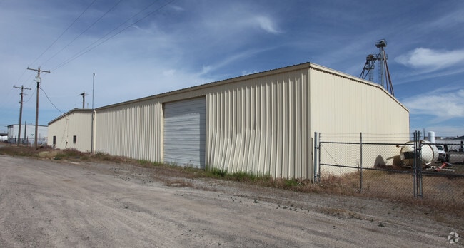

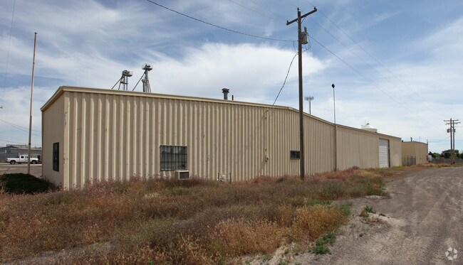
Property Detail
183 Atlantic St
RPT2781007001BA
TWIN FALLS INDUSTRIAL DEV SUBD LOT 1, EXC N 75; LOTS 2 THRU 6 & N ADJ 24.5 VACATED RR SPUR BLOCK 7 (20-10-17 NE)
Warehouse
TWIN FALLS
M-2
Idaho
B and X Area of moderate flood hazard, usually the area between the limits of the 100-year and 500-year floods.
1-6
2025
3.43 AC
2025
Idaho South Area
001202
Other Market Areas
8,376 SF
Twin Falls, ID
NEARBY LISTINGS FOR SALE OR LEASE
DEMOGRAPHICS near 183 Atlantic St
1 mile
3 mile
5 mile
2024 Total Population
5,668
50,194
65,967
2029 Population
5,985
52,888
69,635
Pop Growth 2024-2029
+ 5.59%
+ 5.37%
+ 5.56%
Average Age
36
37
38
2024 Total Households
2,093
18,822
24,388
HH Growth 2024-2029
+ 5.73%
+ 5.45%
+ 5.65%
Median Household Inc
$57,027
$62,155
$65,958
Avg Household Size
2.60
2.60
2.60
2024 Avg HH Vehicles
2.00
2.00
2.00
Median Home Value
$308,445
$307,954
$329,557
Median Year Built
1977
1978
1987
Nearby Places
Map Layers
Map Styles
 Street
 Aerial
Transit
 Traffic
 Biking
Places
Listings with unknown addresses are not visible on the map
- Restaurants
- Banks
- Shops
- Fitness
- Groceries
Nearby Properties
Address
Land Use
TOTAL SIZE
Lot Size
Zoning
Address
Land Use
TOTAL SIZE
Lot Size
Zoning
6,384 SF
5.89 AC
M-2
Address
Land Use
TOTAL SIZE
Lot Size
Zoning
225,980 SF
24.47 AC
C-1
Address
Land Use
TOTAL SIZE
Lot Size
Zoning
382,261 SF
11.44 AC
M-2
Address
Land Use
TOTAL SIZE
Lot Size
Zoning
167,708 SF
14.90 AC
C-1
Address
Land Use
TOTAL SIZE
Lot Size
Zoning
137,048 SF
12.66 AC
C-1
Address
Land Use
TOTAL SIZE
Lot Size
Zoning
240,740 SF
6.74 AC
M-2
Address
Land Use
TOTAL SIZE
Lot Size
Zoning
9,440 SF
7.05 AC
R-6
Address
Land Use
TOTAL SIZE
Lot Size
Zoning
127,520 SF
16.82 AC
M-2
Address
Land Use
TOTAL SIZE
Lot Size
Zoning
20,016 SF
4.40 AC
R-6
Address
Land Use
TOTAL SIZE
Lot Size
Zoning
40,730 SF
0.36 AC
O-T
Address
Land Use
TOTAL SIZE
Lot Size
Zoning
78,849 SF
18.66 AC
M-2
Address
Land Use
TOTAL SIZE
Lot Size
Zoning
5,234 SF
5 AC
R-6
Address
Land Use
TOTAL SIZE
Lot Size
Zoning
233,304 SF
6.01 AC
M-2
Address
Land Use
TOTAL SIZE
Lot Size
Zoning
54,380 SF
2.23 AC
C-1
Address
Land Use
TOTAL SIZE
Lot Size
Zoning
94,366 SF
9.85 AC
M-2
Address
Land Use
TOTAL SIZE
Lot Size
Zoning
52,095 SF
0.22 AC
C-B
Address
Land Use
TOTAL SIZE
Lot Size
Zoning
88,314 SF
8.15 AC
C-1
Address
Land Use
TOTAL SIZE
Lot Size
Zoning
53,953 SF
3.98 AC
R-6
Address
Land Use
TOTAL SIZE
Lot Size
Zoning
46,122 SF
6.37 AC
R-6
Address
Land Use
TOTAL SIZE
Lot Size
Zoning
9,120 SF
4.07 AC
C-1
Address
Land Use
TOTAL SIZE
Lot Size
Zoning
10,536 SF
3.07 AC
C-1
Address
Land Use
TOTAL SIZE
Lot Size
Zoning
74,375 SF
3.02 AC
M-2
Address
Land Use
TOTAL SIZE
Lot Size
Zoning
36,192 SF
0.34 AC
C-B
Address
Land Use
TOTAL SIZE
Lot Size
Zoning
157,403 SF
14.69 AC
M-1
Address
Land Use
TOTAL SIZE
Lot Size
Zoning
29,937 SF
1.25 AC
C-1
Address
Land Use
TOTAL SIZE
Lot Size
Zoning
67,441 SF
4.73 AC
C-1
Address
Land Use
TOTAL SIZE
Lot Size
Zoning
9,088 SF
4.22 AC
R-4
Address
Land Use
TOTAL SIZE
Lot Size
Zoning
24,612 SF
4.70 AC
C-1
The World's #1 Commercial Real Estate Marketplace
Connect with us
© 2026 CoStar Group
The information above has been obtained from sources believed reliable. While we do not doubt its accuracy we have not verified it and make no guarantee, warranty or representation about it. It is your responsibility to independently confirm its accuracy and completeness. Any projections, opinions, assumptions, or estimates used are for example only and do not represent the current or future performance of the property. The value of this transaction to you depends on tax and other factors which should be evaluated by your tax, financial, and legal advisors. You and your advisors should conduct a careful, independent investigation of the property to determine to your satisfaction the suitability of the property for your needs.