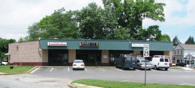
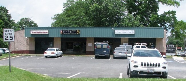
Property Record
183 Mayo Rd, Edgewater, MD 21037

Property Detail
183 Mayo Rd
01-904-05413000
LTS202TO208 219TO222 MAYO RD WOODLAND BEACH
Storebuilding
Anne Arundel
C3
Maryland
B and X Area of moderate flood hazard, usually the area between the limits of the 100-year and 500-year floods.
202
2024
0.39 AC
2025
Southern Anne Arundel
701103
Baltimore
5,482 SF
Baltimore-Columbia-Towson, MD
NEARBY LISTINGS FOR SALE OR LEASE
DEMOGRAPHICS near 183 Mayo Rd
1 mile
3 mile
5 mile
2025 Total Population
8,831
30,154
100,050
2030 Population
8,895
30,606
101,811
Pop Growth 2025-2030
+ 0.72%
+ 1.50%
+ 1.76%
Average Age
41
43
43
2025 Total Households
3,407
11,585
41,088
HH Growth 2025-2030
+ 0.70%
+ 1.59%
+ 1.80%
Median Household Inc
$107,339
$138,130
$118,138
Avg Household Size
2.50
2.50
2.30
2025 Avg HH Vehicles
2.00
2.00
2.00
Median Home Value
$437,243
$592,105
$600,762
Median Year Built
1978
1984
1982
Nearby Places
Map Layers
Map Styles
 Street
 Aerial
Layers
 Traffic
 Biking
Places
Listings with unknown addresses are not visible on the map
- Restaurants
- Banks
- Shops
- Fitness
- Groceries
PUBLIC TRANSPORTATION
AIRPORT
Baltimore/Washington International Thurgood Marshall
Drive
Walk
Distance
Baltimore/Washington International Thurgood Marshall
37 min
25.2 mi
Ronald Reagan Washington Ntl
Drive
Walk
Distance
Ronald Reagan Washington Ntl
51 min
31.7 mi
Freight Ports
Port of Baltimore
Drive
Walk
Distance
Port of Baltimore
43 min
30.5 mi
Nearby Properties
Address
Land Use
TOTAL SIZE
Lot Size
Zoning
Address
Land Use
TOTAL SIZE
Lot Size
Zoning
365,268 SF
4.85 AC
W1
Address
Land Use
TOTAL SIZE
Lot Size
Zoning
589,210 SF
111.38 AC
RA
Address
Land Use
TOTAL SIZE
Lot Size
Zoning
285,174 SF
24 AC
R2
Address
Land Use
TOTAL SIZE
Lot Size
Zoning
138,592 SF
8.47 AC
W1
Address
Land Use
TOTAL SIZE
Lot Size
Zoning
134,693 SF
6 AC
R2
Address
Land Use
TOTAL SIZE
Lot Size
Zoning
117,008 SF
1.40 AC
C4
Address
Land Use
TOTAL SIZE
Lot Size
Zoning
194,350 SF
8.29 AC
R-22
Address
Land Use
TOTAL SIZE
Lot Size
Zoning
132,000 SF
5.55 AC
W1B
Address
Land Use
TOTAL SIZE
Lot Size
Zoning
82,022 SF
50.50 AC
RA
Address
Land Use
TOTAL SIZE
Lot Size
Zoning
112,662 SF
14.44 AC
C3
Address
Land Use
TOTAL SIZE
Lot Size
Zoning
77,261 SF
3.56 AC
C3
Address
Land Use
TOTAL SIZE
Lot Size
Zoning
94,932 SF
9.52 AC
C4
Address
Land Use
TOTAL SIZE
Lot Size
Zoning
77,280 SF
7.52 AC
C2
Address
Land Use
TOTAL SIZE
Lot Size
Zoning
15,093 SF
336.13 AC
R2
Address
Land Use
TOTAL SIZE
Lot Size
Zoning
71,934 SF
8.34 AC
W1
Address
Land Use
TOTAL SIZE
Lot Size
Zoning
63,558 SF
0.43 AC
C2
Address
Land Use
TOTAL SIZE
Lot Size
Zoning
61,141 SF
5.05 AC
C3
Address
Land Use
TOTAL SIZE
Lot Size
Zoning
66,108 SF
3.78 AC
W1
Address
Land Use
TOTAL SIZE
Lot Size
Zoning
54,600 SF
8.18 AC
W1A
Address
Land Use
TOTAL SIZE
Lot Size
Zoning
4.23 AC
R3
Address
Land Use
TOTAL SIZE
Lot Size
Zoning
41,817 SF
15.53 AC
R1
Address
Land Use
TOTAL SIZE
Lot Size
Zoning
41,038 SF
3.84 AC
C2
Address
Land Use
TOTAL SIZE
Lot Size
Zoning
24,283 SF
7 AC
R2
Address
Land Use
TOTAL SIZE
Lot Size
Zoning
73,950 SF
3.46 AC
W1A
Address
Land Use
TOTAL SIZE
Lot Size
Zoning
62,532 SF
10.07 AC
C3
Address
Land Use
TOTAL SIZE
Lot Size
Zoning
29,736 SF
5.14 AC
R5
Address
Land Use
TOTAL SIZE
Lot Size
Zoning
34,136 SF
4.41 AC
R2
Address
Land Use
TOTAL SIZE
Lot Size
Zoning
15,000 SF
7.35 AC
C3
Address
Land Use
TOTAL SIZE
Lot Size
Zoning
55,348 SF
14.98 AC
R5
Address
Land Use
TOTAL SIZE
Lot Size
Zoning
39,568 SF
4.82 AC
C3
The World's #1 Commercial Real Estate Marketplace
Connect with us
© 2026 CoStar Group
The information above has been obtained from sources believed reliable. While we do not doubt its accuracy we have not verified it and make no guarantee, warranty or representation about it. It is your responsibility to independently confirm its accuracy and completeness. Any projections, opinions, assumptions, or estimates used are for example only and do not represent the current or future performance of the property. The value of this transaction to you depends on tax and other factors which should be evaluated by your tax, financial, and legal advisors. You and your advisors should conduct a careful, independent investigation of the property to determine to your satisfaction the suitability of the property for your needs.