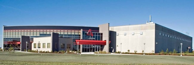
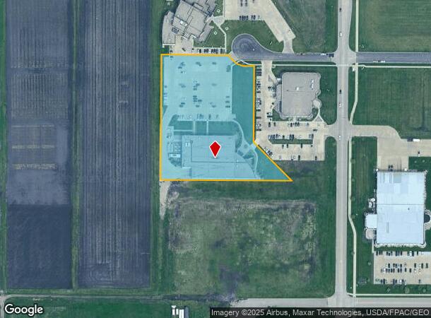
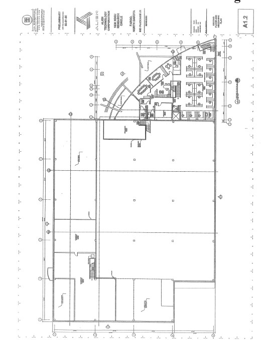
Property Record
1830 Ndsu Research Cir N, Fargo, ND 58102
NEARBY LISTINGS FOR SALE OR LEASE
Property Detail
1830 Ndsu Research Cir N
Fargo, ND-MN
Ndsu Research & Technology Park 2Nd
01-7630-00080-000
LOT: 8 BLOCK: 1 ADDITION: NDSU RESEARCH & TECHNOLOGY PARK 2ND ADDITIONAL: NDSU RESEARCH & TECHNOLOGY PARK 2ND ADDN LT 8 BLK 1
Manufacturinglight
Cass
X
North Dakota
38017C0593G
8
2024
3.98 AC
2024
Fargo
000300
Other Market Areas
36,238 SF
DEMOGRAPHICS near 1830 Ndsu Research Cir N
1 Mile
3 Mile
5 Mile
2024 Total Population
6,154
54,208
132,055
2029 Population
6,408
57,543
139,411
Pop Growth 2024-2029
+ 4.13%
+ 6.15%
+ 5.57%
Average Age
28
37
37
2024 Total Households
1,750
23,457
57,322
HH Growth 2024-2029
+ 7.77%
+ 7.34%
+ 6.37%
Median Household Inc
$39,254
$49,194
$54,732
Avg Household Size
2.00
2.00
2.10
2024 Avg HH Vehicles
2.00
2.00
2.00
Median Home Value
$175,253
$203,971
$221,018
Median Year Built
1973
1969
1977
Nearby Places
Map Layers
Map Styles
 Street
 Aerial
- Restaurants
- Banks
- Shops
- Fitness
- Groceries
PUBLIC TRANSPORTATION
COMMUTER RAIL
Fargo Amtrak Station (Empire Builder - Amtrak)
DRIVE
WALK
Distance
Fargo Amtrak Station (Empire Builder - Amtrak)
7 min
3.1 mi
AIRPORT
Hector International
DRIVE
WALK
Distance
Hector International
7 min
2.5 mi
Freight Ports
Port Milwaukee
DRIVE
WALK
Distance
Port Milwaukee
635 min
575.2 mi
SALE & LEASE HISTORY
LISTING DATE
SALE/LEASE

Oct 11, 2016
For Lease
Nearby Properties
Address
Land Use
TOTAL SIZE
Lot Size
Zoning
Address
Land Use
TOTAL SIZE
Lot Size
Zoning
17.38 AC
Address
Land Use
TOTAL SIZE
Lot Size
Zoning
122,006 SF
24.45 AC
GI
Address
Land Use
TOTAL SIZE
Lot Size
Zoning
121,584 SF
5.64 AC
MR3
Address
Land Use
TOTAL SIZE
Lot Size
Zoning
175,969 SF
35.10 AC
GI
Address
Land Use
TOTAL SIZE
Lot Size
Zoning
621,097 SF
49.49 AC
LI
Address
Land Use
TOTAL SIZE
Lot Size
Zoning
12.07 AC
Address
Land Use
TOTAL SIZE
Lot Size
Zoning
107,995 SF
1 AC
DMU
Address
Land Use
TOTAL SIZE
Lot Size
Zoning
5.23 AC
Address
Land Use
TOTAL SIZE
Lot Size
Zoning
3.31 AC
Address
Land Use
TOTAL SIZE
Lot Size
Zoning
0.17 AC
Address
Land Use
TOTAL SIZE
Lot Size
Zoning
73.98 AC
Address
Land Use
TOTAL SIZE
Lot Size
Zoning
109,174 SF
1.25 AC
UMU
Address
Land Use
TOTAL SIZE
Lot Size
Zoning
2.07 AC
Address
Land Use
TOTAL SIZE
Lot Size
Zoning
12.33 AC
PAC
Address
Land Use
TOTAL SIZE
Lot Size
Zoning
303,970 SF
49.72 AC
GI
Address
Land Use
TOTAL SIZE
Lot Size
Zoning
Address
Land Use
TOTAL SIZE
Lot Size
Zoning
206,540 SF
16.68 AC
GI
Address
Land Use
TOTAL SIZE
Lot Size
Zoning
10.87 AC
Address
Land Use
TOTAL SIZE
Lot Size
Zoning
Address
Land Use
TOTAL SIZE
Lot Size
Zoning
75 AC
MHP
Address
Land Use
TOTAL SIZE
Lot Size
Zoning
6.84 AC
Address
Land Use
TOTAL SIZE
Lot Size
Zoning
Address
Land Use
TOTAL SIZE
Lot Size
Zoning
152,508 SF
13.85 AC
GI
Address
Land Use
TOTAL SIZE
Lot Size
Zoning
106,250 SF
1.25 AC
DMU
Address
Land Use
TOTAL SIZE
Lot Size
Zoning
242,032 SF
14.23 AC
GI
Address
Land Use
TOTAL SIZE
Lot Size
Zoning
Address
Land Use
TOTAL SIZE
Lot Size
Zoning
20,136 SF
0.89 AC
MR3
Address
Land Use
TOTAL SIZE
Lot Size
Zoning
12.97 AC
GI
Address
Land Use
TOTAL SIZE
Lot Size
Zoning
Address
Land Use
TOTAL SIZE
Lot Size
Zoning
17,309 SF
0.23 AC
DMU
The World's #1 Commercial Real Estate Marketplace
Connect with us
© 2025 CoStar Group
The information above has been obtained from sources believed reliable. While we do not doubt its accuracy we have not verified it and make no guarantee, warranty or representation about it. It is your responsibility to independently confirm its accuracy and completeness. Any projections, opinions, assumptions, or estimates used are for example only and do not represent the current or future performance of the property. The value of this transaction to you depends on tax and other factors which should be evaluated by your tax, financial, and legal advisors. You and your advisors should conduct a careful, independent investigation of the property to determine to your satisfaction the suitability of the property for your needs.