Property Record
18303 Perkins Rd E, Baton Rouge, LA 70810


Save to a Folder
{{folder.Name}}
{{folder.ListingIds.length}} Properties
{{folder.ListingIds.length}} Property
Create a New Folder
Property Detail
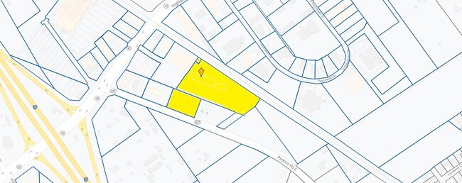
18303 Perkins Rd E
Baton Rouge
WARD: 3-3, SUBDIVISION: OLD HOME PLACE TRACTS, LOT: Y-1-C-2-A. TRACT Y-1-C-2-A, CONT. 7.268 ACRES RESUB. OF TRACT Y-1-C-2, LE
Baton Rouge, LA
E BATON ROUGE
02886391
Louisiana
Storesoffices
y-1-
2025
7.27 AC
2025
Essen/Bluebonnet
004022
NEARBY LISTINGS FOR SALE OR LEASE
DEMOGRAPHICS near 18303 Perkins Rd E
1 mile
3 mile
5 mile
2025 Total Population
2,037
32,000
92,689
2030 Population
2,000
31,939
92,527
Pop Growth 2025-2030
(1.82%)
(0.19%)
(0.17%)
Average Age
46
40
40
2025 Total Households
781
12,453
37,350
HH Growth 2025-2030
(1.79%)
(0.35%)
(0.39%)
Median Household Inc
$148,426
$108,121
$100,235
Avg Household Size
2.60
2.50
2.40
2025 Avg HH Vehicles
2.00
2.00
2.00
Median Home Value
$703,084
$362,072
$338,021
Median Year Built
2001
1996
1994
Nearby Places
Map Layers
Map Styles
 Street
 Aerial
Layers
 Traffic
 Biking
Places
Listings with unknown addresses are not visible on the map
- Restaurants
- Banks
- Shops
- Fitness
- Groceries
PUBLIC TRANSPORTATION
AIRPORT
Baton Rouge Metro Ryan Field
Drive
Walk
Distance
Baton Rouge Metro Ryan Field
26 min
20.2 mi
Freight Ports
Port of Greater Baton Rouge
Drive
Walk
Distance
Port of Greater Baton Rouge
22 min
15.4 mi
SALE & LEASE HISTORY
LISTING DATE
SALE/LEASE

Jan 15, 2020
For Lease
Nearby Properties
Address
Land Use
TOTAL SIZE
Lot Size
Zoning
Address
Land Use
TOTAL SIZE
Lot Size
Zoning
502,888 SF
28.87 AC
Address
Land Use
TOTAL SIZE
Lot Size
Zoning
12.21 AC
Address
Land Use
TOTAL SIZE
Lot Size
Zoning
490,875 SF
12 AC
Address
Land Use
TOTAL SIZE
Lot Size
Zoning
126,124 SF
19.66 AC
Address
Land Use
TOTAL SIZE
Lot Size
Zoning
23.33 AC
MU
Address
Land Use
TOTAL SIZE
Lot Size
Zoning
12.15 AC
Address
Land Use
TOTAL SIZE
Lot Size
Zoning
18.98 AC
RM
Address
Land Use
TOTAL SIZE
Lot Size
Zoning
134,175 SF
23.88 AC
Address
Land Use
TOTAL SIZE
Lot Size
Zoning
23.68 AC
Address
Land Use
TOTAL SIZE
Lot Size
Zoning
12.24 AC
Address
Land Use
TOTAL SIZE
Lot Size
Zoning
83,950 SF
11.45 AC
Address
Land Use
TOTAL SIZE
Lot Size
Zoning
Address
Land Use
TOTAL SIZE
Lot Size
Zoning
113,271 SF
13.59 AC
Address
Land Use
TOTAL SIZE
Lot Size
Zoning
13.13 AC
Address
Land Use
TOTAL SIZE
Lot Size
Zoning
188,617 SF
10.36 AC
Address
Land Use
TOTAL SIZE
Lot Size
Zoning
125,942 SF
15.89 AC
Address
Land Use
TOTAL SIZE
Lot Size
Zoning
87,592 SF
3.95 AC
Address
Land Use
TOTAL SIZE
Lot Size
Zoning
144,000 SF
7.26 AC
Address
Land Use
TOTAL SIZE
Lot Size
Zoning
65,916 SF
9.38 AC
Address
Land Use
TOTAL SIZE
Lot Size
Zoning
Address
Land Use
TOTAL SIZE
Lot Size
Zoning
10.88 AC
Address
Land Use
TOTAL SIZE
Lot Size
Zoning
273,658 SF
20 AC
Address
Land Use
TOTAL SIZE
Lot Size
Zoning
73,319 SF
18.05 AC
Address
Land Use
TOTAL SIZE
Lot Size
Zoning
Address
Land Use
TOTAL SIZE
Lot Size
Zoning
92,209 SF
7.08 AC
Address
Land Use
TOTAL SIZE
Lot Size
Zoning
107,805 SF
11.38 AC
Address
Land Use
TOTAL SIZE
Lot Size
Zoning
22,600 SF
2.70 AC
Address
Land Use
TOTAL SIZE
Lot Size
Zoning
Address
Land Use
TOTAL SIZE
Lot Size
Zoning
31,080 SF
6 AC
Address
Land Use
TOTAL SIZE
Lot Size
Zoning
8,560 SF
31.06 AC
The World's #1 Commercial Real Estate Marketplace
Connect with us
© 2026 CoStar Group
The information above has been obtained from sources believed reliable. While we do not doubt its accuracy we have not verified it and make no guarantee, warranty or representation about it. It is your responsibility to independently confirm its accuracy and completeness. Any projections, opinions, assumptions, or estimates used are for example only and do not represent the current or future performance of the property. The value of this transaction to you depends on tax and other factors which should be evaluated by your tax, financial, and legal advisors. You and your advisors should conduct a careful, independent investigation of the property to determine to your satisfaction the suitability of the property for your needs.