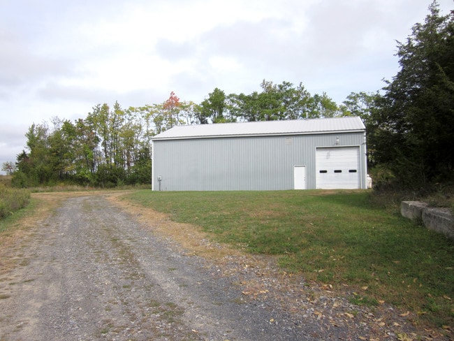
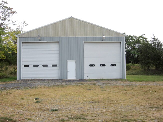
Property Record
1831 Kings Hwy, Chester, NY 10918
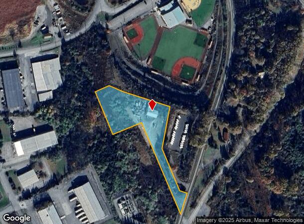
NEARBY LISTINGS FOR SALE OR LEASE
Property Detail
1831 Kings Hwy
New York-Jersey City-White Plains, NY-NJ
Kakargo
332289-006-000-0001-067.100-0000
LT 4 KAKARGO SUB MAP 7734
Warehouse
Orange
X
New York
36071C0459E
67.10
2024
2.40 AC
2024
Orange County
014302
Northern New Jersey
2,400 SF
DEMOGRAPHICS near 1831 Kings Hwy
1 Mile
3 Mile
5 Mile
2024 Total Population
1,315
10,869
42,521
2029 Population
1,330
11,010
43,352
Pop Growth 2024-2029
+ 1.14%
+ 1.30%
+ 1.95%
Average Age
40
41
40
2024 Total Households
442
3,808
14,387
HH Growth 2024-2029
+ 1.13%
+ 1.34%
+ 2.06%
Median Household Inc
$124,839
$122,156
$119,985
Avg Household Size
2.90
2.80
2.80
2024 Avg HH Vehicles
2.00
2.00
2.00
Median Home Value
$357,079
$367,499
$365,064
Median Year Built
1956
1979
1976
Nearby Places
- Restaurants
- Banks
- Shops
- Fitness
- Groceries
PUBLIC TRANSPORTATION
AIRPORT
New York Stewart International
DRIVE
WALK
Distance
New York Stewart International
31 min
16.7 mi
Freight Ports
Port Newark Container Terminal
DRIVE
WALK
Distance
Port Newark Container Terminal
81 min
60.6 mi
Nearby Properties
Address
Land Use
TOTAL SIZE
Lot Size
Zoning
Address
Land Use
TOTAL SIZE
Lot Size
Zoning
389 AC
02092
Address
Land Use
TOTAL SIZE
Lot Size
Zoning
878,010 SF
50.40 AC
Address
Land Use
TOTAL SIZE
Lot Size
Zoning
1,313,710 SF
34 AC
SR2*
Address
Land Use
TOTAL SIZE
Lot Size
Zoning
198,260 SF
27.60 AC
B2
Address
Land Use
TOTAL SIZE
Lot Size
Zoning
50.30 AC
I
Address
Land Use
TOTAL SIZE
Lot Size
Zoning
404,550 SF
35.90 AC
M1
Address
Land Use
TOTAL SIZE
Lot Size
Zoning
319,144 SF
47.80 AC
IP
Address
Land Use
TOTAL SIZE
Lot Size
Zoning
100,324 SF
0.66 AC
RS
Address
Land Use
TOTAL SIZE
Lot Size
Zoning
116,426 SF
9.10 AC
M1
Address
Land Use
TOTAL SIZE
Lot Size
Zoning
211,990 SF
13.10 AC
M1
Address
Land Use
TOTAL SIZE
Lot Size
Zoning
12.80 AC
AR3
Address
Land Use
TOTAL SIZE
Lot Size
Zoning
194,400 SF
28.10 AC
I
Address
Land Use
TOTAL SIZE
Lot Size
Zoning
92,969 SF
4.98 AC
M1
Address
Land Use
TOTAL SIZE
Lot Size
Zoning
282,147 SF
7.50 AC
M2
Address
Land Use
TOTAL SIZE
Lot Size
Zoning
5 AC
IP
Address
Land Use
TOTAL SIZE
Lot Size
Zoning
52,575 SF
64.60 AC
AR3*
Address
Land Use
TOTAL SIZE
Lot Size
Zoning
71,910 SF
10.80 AC
Address
Land Use
TOTAL SIZE
Lot Size
Zoning
61,975 SF
10.80 AC
M1
Address
Land Use
TOTAL SIZE
Lot Size
Zoning
159,063 SF
18.80 AC
M1
Address
Land Use
TOTAL SIZE
Lot Size
Zoning
86,696 SF
153.50 AC
A1OP
Address
Land Use
TOTAL SIZE
Lot Size
Zoning
19,440 SF
6.80 AC
RM
Address
Land Use
TOTAL SIZE
Lot Size
Zoning
101,476 SF
6.30 AC
M1
Address
Land Use
TOTAL SIZE
Lot Size
Zoning
82,927 SF
10.10 AC
4500
Address
Land Use
TOTAL SIZE
Lot Size
Zoning
43,664 SF
3.10 AC
B2
Address
Land Use
TOTAL SIZE
Lot Size
Zoning
43,738 SF
16.90 AC
GC
Address
Land Use
TOTAL SIZE
Lot Size
Zoning
88,440 SF
4.50 AC
M1
Address
Land Use
TOTAL SIZE
Lot Size
Zoning
63,068 SF
10.80 AC
M1
Address
Land Use
TOTAL SIZE
Lot Size
Zoning
43,952 SF
14.10 AC
B2
Address
Land Use
TOTAL SIZE
Lot Size
Zoning
18.30 AC
AR3*
Address
Land Use
TOTAL SIZE
Lot Size
Zoning
72,430 SF
5.60 AC
M2
The World's #1 Commercial Real Estate Marketplace
Connect with us
© 2025 CoStar Group
The information above has been obtained from sources believed reliable. While we do not doubt its accuracy we have not verified it and make no guarantee, warranty or representation about it. It is your responsibility to independently confirm its accuracy and completeness. Any projections, opinions, assumptions, or estimates used are for example only and do not represent the current or future performance of the property. The value of this transaction to you depends on tax and other factors which should be evaluated by your tax, financial, and legal advisors. You and your advisors should conduct a careful, independent investigation of the property to determine to your satisfaction the suitability of the property for your needs.